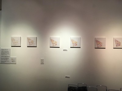
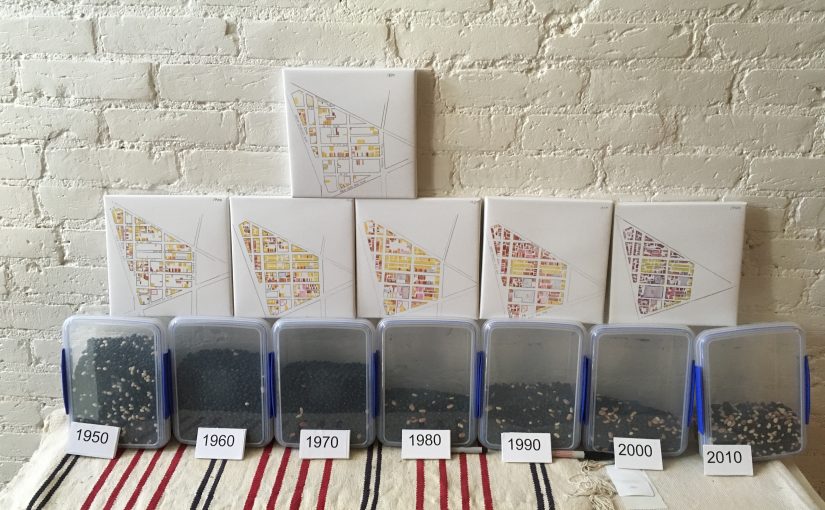
This is not really from the exhibit, but part of the art piece I created called Frankenmap. This looks like the Son of Frankenmap, where it is just the parts of Truxton Circle along New Jersey Avenue. It looks like I’ve posted all the material fit to post and now I’m digging into the bottom of the barrel.
Tag: Truxton Circle
The Triangle Known As Truxton Circle: Change 1880-1940
Back in 2017, I and two artist neighbors set up an exhibit at 410 GoodBuddy called The Triangle Known as Truxton Circle. I have a few things sitting on my computer from the exhibit that I’d like to share. Between no childcare and attempting to telework in less than ideal conditions, yes, I’m not posting much. But I can post this from the exhibit.
I believe this was part of Beans!, which I will get to later. I really love Beans! But you can’t appreciate Beans! until you’ve seen the maps.
Change 1880-1940
Digital print on canvas
I used US Census and city directory information to show changes in the neighborhood from 1880 (the first census with street addresses) to 1940 (the latest open census). The census is taken every 10 years.
Compare the different years, and see how the neighborhood fills in.When does the neighborhood transform into a majority African American neighborhood?
Please go to BEANS! to see the continuation of the transformation.
Unlike my other Triangle posts I’m going to go a bit more into the images.
Okay the key for all these maps is:
Yellow- Whites
Brown- African Americans
Green- Asians- usually Chinese
Blue- Government facilities, if filled with brown- Black school
Purple- Commercial property

This is where black and white residents lived in the northwest part of what is now known as Truxton Circle in 1880. It is a mostly white and lightly populated neighborhood.
 So these maps are based on the US Census and the 1890 census got burned so, there is no 1890 map. So by the time 1900 rolls around as seen above there have been some big changes. There has been more development, more housing and businesses, and there is a hospital between N St and New York Avenue. Langston and Slater appear over on the unit block of P Street. So students who were not served by the white school on 3rd St, have options. The Black/White population looks kinda even, but it isn’t. The TC is still a majority white neighborhood.
 In 1910 the neighborhood has filled many of it’s empty spaces with white households, which is still the majority.
 You can’t see it from the map but the African American population is growing. A bit crowded in the units they occupy, but growing. 1920 is the last year the non-Black population is the majority. By 1920 three more schools for African Americans appear. And then Boom.
1930!
This is where the neighborhood finally becomes the historically Black neighborhood we all know and love.
 Yes, 1940 looks different. What is brown looks purple. As you can tell this map was made at a different time. It was made quickly and specifically for the exhibit, and thus, not as good as the others. As 1940 was the last open Census available where I could say what racial group lived at what particular address, this is the last map.
The Triangle Known As Truxton Circle- Frankenmaps
Back in 2017, I and two artist neighbors set up an exhibit at 410 GoodBuddy called The Triangle Known as Truxton Circle. I have a few things sitting on my computer from the exhibit that I’d like to share. Between no childcare and attempting to telework in less than ideal conditions, yes, I’m not posting much. But I can post this from the exhibit.
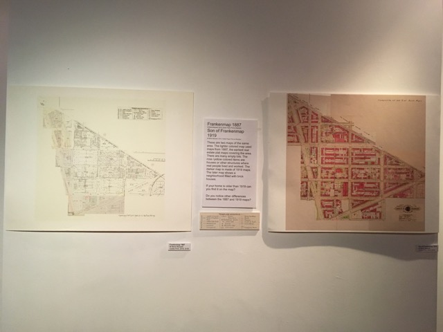
Below are two maps I created from older maps. The thing was none of the old fire maps had Truxton Circle on one map. I had to piece the maps together from several maps, just as Dr. Frankenstein pieced together his creature. I sold the older view of the TC and have kept the 1919 map for myself.
Frankenmap 1887
2016, Giclée Paper Print on Bamboo
Son of Frankenmap 1919
2016, Giclée Paper Print on Bamboo
These are two maps of the same area. The lighter colored map used maps from 1887, the earliest real estate plat maps covering the area. There are many empty lots. The rose /yellow colored items are houses or other structures where real people lived and worked. The darker map is made of 1919 maps. The later map shows a neighborhood filled with brick houses.
If your home is older than 1919 can you find it on the map?
Do you notice other differences between the 1887 and 1919 maps?
Triangle Known As Truxton Circle: Bulldoze a road through it
Back in 2017, I and two artist neighbors set up an exhibit at 410 GoodBuddy called The Triangle Known as Truxton Circle. I have a few things sitting on my computer from the exhibit that I’d like to share. Between no childcare and attempting to telework in less than ideal conditions, yes, I’m not posting much. But I can post this from the exhibit. First is the image then the exhibit text. Enjoy.
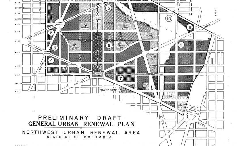
Freeway Plan circa 1957-1960
2016, Digital Print on Foamboard
This is a map of what could have been. It is an undated planning map from the National Capital Planning Commission. Truxton Circle is the upper green area of the map. In this version I-395 does not stop at New York Avenue but continues north to meet with a planned east-west freeway between P and U Streets.
Do you know why I-395 ends where it does?
Who would these freeways serve?
If the freeway didn’t stop at New York Avenue, would your house still exist?
Black Home Owners of 1940: Let’s clean up some data
Disclaimer: This has been sitting in drafts for a year. I forgot what was wrong with it. I’m gonna roll the dice and publish it.
So I have a goal to create a big ole spreadsheet of all the residents for all the censuses. Buuuuuut I need to clean up the data. The problem with the Census is sometimes I swear some of the enumerators were raging alcoholics who couldn’t find a job doing anything else. The census data is not pure, nor perfect. Sometimes a person’s only appearance is in the census, but sometimes they’ll appear elsewhere. They’ll be men who had to sign up for the draft, or business people or others who appear in city directories, and for owners after 1921 they’ll be in the Recorder of Deeds website.
So I’m going to look at homeowners who’s square or address has a question mark. These people are Clarence Washington of 126 FL Ave NW, Raymond Montgomery of 121 , Rudolph Blake of 137, Joseph Gibson of 136 Bates St NW, Florence Glover of 109 Q St NW, Jerome S. Jenkyns of 1641, John Lattimer of 1464, Roscoe Patrick, and Laura Ford of 1684 3rd St NW.
I located Clarence Washington on Square 551 lot 172. Now the problem is, that lot no longer exists. The Florida Avenue park sits there. It looks like he’s at 126 FL Ave NW, where previously he might have been at 124. It was unclear. Looking at the records, he obtained his property on September 14, 1935 with a 6% loan from National Savings and Trust Company. He appears to have been single at the time of purchase. He and his wife Clara (listed in the 1940 census) sold the house in April 1948.
Raymond Montgomery had purchased a fair amount of property, well at least someone with that name did so. Just looking at square 552 he owned lot 152, and in the current year that lot’s address is 123 P St NW. So not 121 Bates St NW as I had him in my data. Then a widower in February 1938 he bought the property. According to a October 1965 deed selling the house to a Lucille Baskin, Raymond died February 4, 1959 leaving his wife Estella a widow.
Rudolph S. Blake is another popular name for a property holder. Once again just focusing on Truxton Circle I can pin him down to Sq. 552 lot 159 (137 P St NW) starting in 1925 with his wife Ida B. She sells the property in 1948 after Rudolph as died.
Joseph and wife Novella Gibson are a problem. They are associated with property on squares 551 and 552. The documents for 551 appear to be an outlier as it is concerning a party wall between 213 and 215 Q St NW (Sq 551 lots 7 & 8). I believe they probably lived on square 552 on lot 206, currently 136 Bates St NW. February 1926 Joseph and wife “Navalla” obtain 136 Bates with a $2,250 loan at 6% APR with monthly payments of $30. The Gibsons sell in 1965 to Barney and Henrietta Weitz.
It appears widow Florence O. Glover buys 109 Q St NW, which no longer exists, in 1925. By the sale of the property to the DL & W company in 1957, it seems she is dead. A Florence Glover is deceased as mentioned in the deed, but her daughter was also named Florence Glover, so there is confusion there. And there are more than half a dozen Glovers mentioned on the document. Please don’t leave property to more than 2 unmarried (sans spouses) relatives, it’s really confusing.
Jerome and Ellena Jenkyns bought their home 1629 3rd St NW in 1922, if the records are correct. Once again this is another property that no longer exists. The property was sold in 1972 to the Redevelopment Land Agency (RLA) by the heirs. The document listed Jerome dying around about May 24, 1965 and Ellena dying around May 8, 1948.
Truxton Circle Property Owners, 1933
Okay the pages for Squares 507 to 510 East are crap. But the pages for Squares 519-521, 550-555, 614-618 and 668-670 (the NE Truxton) are readable.
What is it?
The National Archives has images of some of their stuff in their catalog. So I pulled out parts that pertained to Truxton Circle, here (for a better image of sq. 507-510E), and here. This is just more evidence for the history of Truxton Circle. If I (or someone else, hint, hint) decide to cross reference this list of property owners with a city directory or the 1930 Census, we could see who were landlords and who were homeowners. All sorts of questions could crop up from the data.
Anyway, here’s the pdf.
Truxton Circle 1933 Property Owners by Mm Inshaw on Scribd
Same old house, new and improved and expensive
A minor irritation I have with some essays on gentrification and housing is a complete failure to acknowledge investment and disinvestment in physical structures.
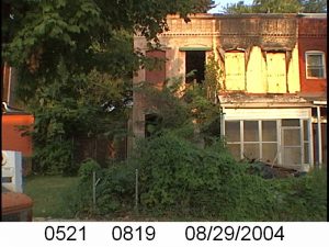 This is an August 2004 PropertyQuest picture of 1504 3rd Street NW. I have an earlier one from 2003.
Anyway, it sold in August for $765,000. According to the data on Redfin, it sold in 1991 for $76,750. Between 2001-2006 this shell of a house kept getting listed and delisted. I’m not going to do any in-depth research to determine if it changed hands in that period, but in December 2006 it sold for $250,000. Then in 2007 it sold for about $450K, by this time it had definitely been renovated. This year it came back on the market and sold in the mid $700K range.
When someone takes this house and other houses in the neighborhood and just sees prices, what are they thinking? Do they think the rise in price is just arbitrary and an effort to keep lower-income households priced out?
What I witnessed was investment coming into the neighborhood. That house in 2003-2004 was a shell, unfit for human habitation. That was a result of disinvestment when it wasn’t worth it for the owner to maintain the structure. Shaw had experienced a lot of disinvestment. After the riots in 1968, many businesses didn’t return. Some residents and landlords just abandoned the neighborhood because it wasn’t worth the money to them to fix the damage.
To take a shell from being unfit to being desirable takes capital, investment. Someone paid to buy cabinetry, flooring, windows, paint, drywall, electrical wires, PVC pipes, HVAC system, framing, appliances, and a roof. Plus the labor to install these things. Having renovated my house and another property, I can say this is not cheap. At the very least $100K went into making the house livable.
Well the house was already renovated by 2007, can I justify the $300K-$400K price hike between 2007 and 2019? I can’t tell if the rear deck was already there, but it was the neighborhood that changed in the period that made it more valuable. What happened between 2007 and now? Big Bear, a few blocks away opened up. Then the Bloomingdale Farmers Market about a year later. Nightly gunshots became less of a thing. There are a handful of sit down restaurants within walking distance, 3 that have had or have Michelin mentions. Two with 1 Michelin star within, biking…longer walking distance. Also, other houses in the neighborhood have been renovated and owners have a financial incentive to maintain their properties. But does that justify the price increase? How much is a safer (2019 TC is way safer than 2004 TC) neighborhood worth? How much is it worth to have places to take friends/dates that are a nice stroll back to your place? Schools have improved, and as a parent, it is worth a few thousand to have a plethora of Pre-K choices in walking distance. As a homeowner, there is a disappointing difference between what you can refinance and what is a possible sales price. The improvements in the neighborhood have allowed us to refinance the house to fix it up, but the value to bank says the house is worth was much, much lower than what was selling around us. But all that is meaningless if all you care about is keeping the price of housing down.
1949 Incomes for the TC
I’m going to try something here and see if it fits.
It is from https://catalog.archives.gov/id/140129446 and Truxton Circle, the NW section of it (not that tip on the other side of North Cap), is Census Tract 46. Also “Non-Wh.” is just Black people…. and maybe that one Asian that always shows up in the census.
I Still Don’t Know Why A DOEE Clean Up Is Needed for Q St NW
So Bloomingdame asked me via a tweet why a clean up would be needed for the area of Florida and Q St NW. Then that Sunday Scott Roberts asked me about this. So during my lunch I looked for an answer in the 1970-1969 City Directory, because someone else asked a similar question for another part of Truxton Circle.
I’m guessing the laundries, the car lot and the dry cleaners might have a little something to do with it. Looking at the 1952 aerial photo, there were structures on that section of the street, so maybe someone is being super duper careful or adding a hurdle to development.
What are the neighborhoods of Shaw?
Okay, I need to regularly post this topic. Because DC is a city that attracts people from elsewhere, the nuances of the city’s history get lost over time with each new fresh face.
There is a piece in the Washington Post, a “Where we live” real estate article about Truxton Circle. There is a line that refers to other neighborhoods, Bloomingdale and Shaw. I’m only going to nit pix here and state, once again, Truxton Circle is in Shaw. I thought I mentioned it to the writer to reached out to me for contacts, when I warned her about the group of residents who hate the name ‘Truxton Circle’.

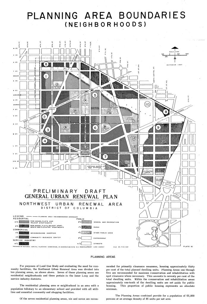
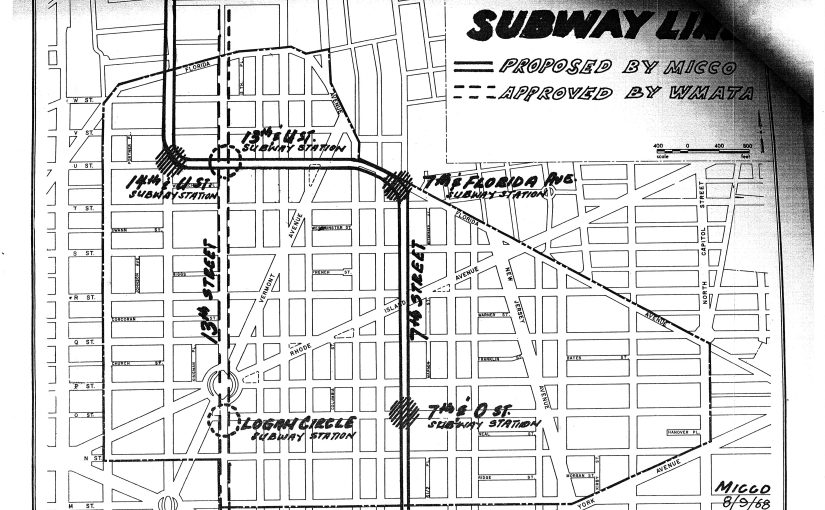
Look at this map above. Let’s point out a few of the neighbhorhoods covered by this circa 1968 map of the Shaw School Urban Renewal Area.
U Street
Let’s start in the north with the top of the map where we have the area currently known as U Street. Formally this was the city’s Black Broadway. What are the boundaries? Beats me. Let’s say U St and Florida Ave NW.
Truxton Circle (most)
Coming over the east in a clockwise direction, we have the NW section of Truxton Circle. There is a NE section that I ignore most of the time. That north east section is not part of the original Shaw neighborhood.
Mt. Vernon Square (part)
Funny thing, there are parts of Mt. Vernon Square, or at least the Mt. Vernon Square Historic District (map, PDF) in Truxton Circle. And there are parts of Mt. Vernon Sq. outside of Shaw. This is in the southeastern part of Shaw and bordering Shaw. There is an overlapping. Don’t freak out, it’s okay.
Mid-City
Now this is the section that these days gets touted as the current boundaries of Shaw, although I don’t know who redrew them. Mid-city contains within it, the small historic districts of Blagden Alley and Naylor Court. It also has the most awesome restaurants.
Logan Circle
Finishing our loop around Shaw is Logan Circle to the west. According to the Logan Circle Community Association the boundaries are: “S Street to the north, K Street to the south, 9th Street to the east, and 16th Street to the west.”


