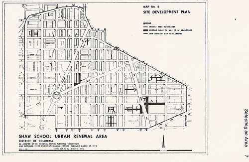
Everyso often people argue about the boundaries of the Shaw neighborhood. Here’s a map from 1971 from the National Capital Planning Commission. It also shows the 14th St Urban Renewal Area, but little matter.
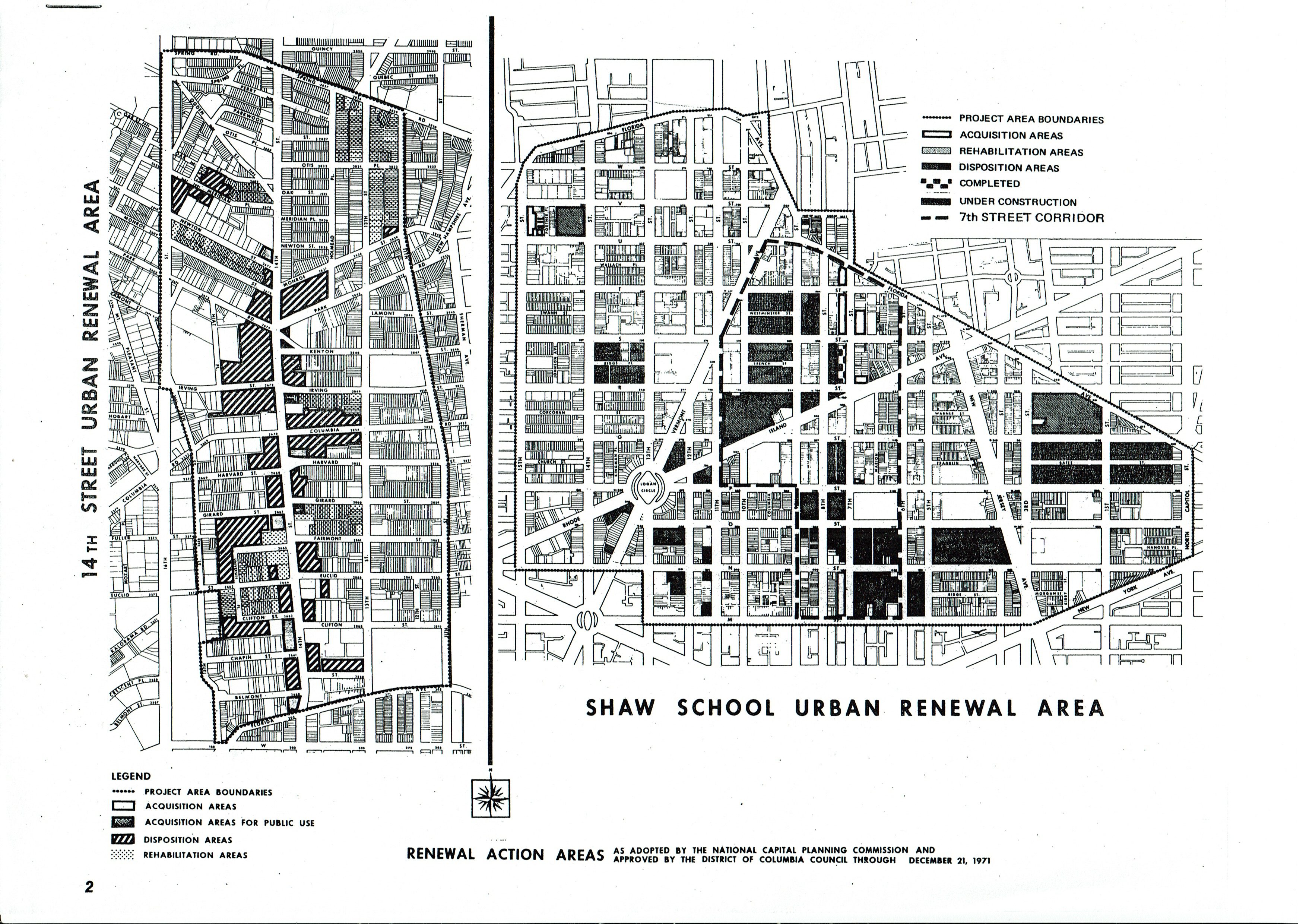
Everyso often people argue about the boundaries of the Shaw neighborhood. Here’s a map from 1971 from the National Capital Planning Commission. It also shows the 14th St Urban Renewal Area, but little matter.

I am not sure but I believe the billboards that were on the corner were down.
So I decided to fool around with AI before it takes my job and brings those Boston Dynamic killer dog robots to kill me.
I was playing with NotebookLM and decided to throw some Eloyce Gist stuff at it. The fake podcast it produced…. is interesting.
After asking several Eloyce Gist questions, I asked it about Truxton Circle. This is what I got:
While the sources provide information about a filmmaker who lived and worked in Truxton Circle, they do not offer a clear definition of “Truxton Circle.” The sources do include some clues about the nature of Truxton Circle, which may help to clarify:● A historically Black neighborhood in Washington, D.C.: Several sources refer to Truxton Circle as a neighborhood in Washington, D.C. that was historically Black. For example, one source describes Truxton Circle as a “historically Black Truxton Circle neighborhood in Washington, DC.”Another mentions a series on “Black home owners of Truxton Circle.”
● Home to a beauty school in the 1920s: The sources provide details about the life and work of Eloyce Gist, a Black filmmaker who owned and operated a beauty school in Truxton Circle in the 1920s. Gist purchased the property for her business, the Patrick School of Beauty Culture and Personal Improvements, in 1922.The sources note that, at the time, Truxton Circle was “just becoming a majority Black neighborhood.”
● Located within the pre-Home Rule boundaries of Shaw: Several sources provide a map of the “Boundaries pre-Home Rule” for Shaw, a neighborhood in Washington, D.C..
This is a repost. But the topic is always something that applies.
Okay so there is a write up in the Washington Post about Shaw. I’m debating about giving Alex Padro a hard time about the east boundary being New Jersey Avenue. Their graphic has Shaw’s western boundary at 13th St NW and the southern part just eats up Mt. Vernon . The boundaries of Shaw keep changing with each article so, there is that. This is a Real Estate article, and they quote Padro and Ibrahim Mumin, so I’m not going to nit pick much, except for this point.
Anyway, here’s a map
and this gem
and this…
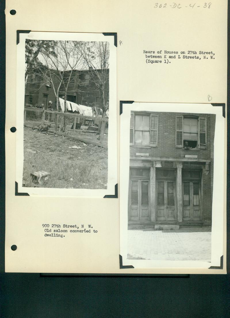
This is part of the Rando Alley Not in Shaw series. However, this is not even an alley. This is Square 1. Literally Square 1 in NW DC and 900 27th Ave NW, which no longer exist. What is there now is the off ramp to go from Whitehurst Freeway to I-66.
 Dates? Pffft…. Between 1916 and 1936-ish.
The Recorder of Deeds website was being unhelpful. So this is mostly from Ancestry and the Historic Washington Post. Genealogy is hard. I refuse to do my dad’s side of the family because most of it could be summed up in the phrase, “Grandpa James shoulda kept it in his pants.” There are two James, two Roberts and two Johns. Families seem to like to recycle names, which makes things confusing and I was, and probably still am, confused by the Kat Millers of Sq. 520.
I mentioned Kat Miller, as I will call them, in an earlier post, Rando thoughts ending in a music video. For 1905-1906, on Square 520, which is bounded by R St, 3rd and 4th Sts, and Q Street NW, I saw a lot of Kat Millers as the owner of many lots. Katharine Miller owned lots 57-59, 62, 76-78, 88-86, and 90-91. Katharina Miller owned lot 92. Catherine A. Miller owned lots 60, 93-94, and 102-106. There was another lady Miller, Agnes R. Miller who owned lots 61, 65 and 95.
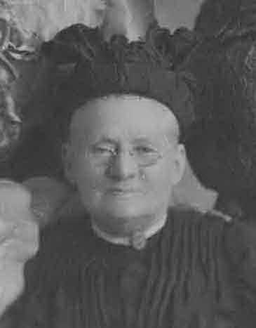
Like my family, they reused the names. Katharina/ Katrina Elizabeth Nau Miller (1839-1916) was the mother. She was married to a John Miller and they used to live at 452 H St NW. They were members of St. Mary’s Catholic Church. They had three daughters, Catherine Appollonia (1871-1944), Agnes Rose (1878-1930), and Anna Barbara (1876-1950).
The Recorder of Deeds site (when working) helped with something that is very hard when looking up women, married names. Apparently Katharina had a will. I haven’t seen it but I’ve seen evidence of it. But according to land records there was a will and Catherine Appollonia Miller became Catherine Ruppert. She and her husband John Anton Ruppert (1861-1939) were the executors of Katharina’s will. In her will she left property to the surviving children of Agnes Rose Sullivan (lots 57, 78, 88, and 90) along with lots on Sq. 509 (maybe 509E?). In the September 16, 1916 Washington Post (p. 3) she left property and money to Catherine Ruppert, Agnes’ kids, and Anna Barbara Gaegler. Mrs. Gaegler owned lots 68 and 74 in 1905.
I’m not sure who John F. Shea is, but he was the surviving trustee of Catherine Ruppert’s estate.

Okay. Let’s see who these ladies were landladies for. I’m ignoring all the lots owned by Sullivans, who could be relatives of Agnes Rose. So let’s look at lots 57-62, 65, 68, 74, 76-78, 86-88, 90-95, 102-106. Not all the old lot numbers line up with the current lot numbers, and the Baist addresses can be wrong, so bear with me. 1603-1611 and 1629 4th, 1635 4th, 1641 4th, 1646 3rd, 1638-1642 3rd (empty lots), 1618-1622 3rd, 1602/4?? 3rd (empty lot 95), 1604-1614 3rd, and 304-312 R St NW.
In 1900 the residents of 1603-1611 and 1629 4th St NW were all African American. Basically everyone on Square 520 in 1900 was Black and renting and on 4th St NW. Unless I have another hole in my data (and I probably do), these white ladies had black tenants in fairly, newish houses. I live on the even side of the 1600 block of 4th St NW and the houses on the odd side are way bigger than the even side. They have room for parking. We don’t, for most of us.
Moving to 1910, I see I probably have a hole in my 1900 data because, I see White people. In 1910 the Miller ladies rented to African American and White families. Fourth St remains African American, but the R Street and 3rd Street houses are rented to White families. I have one odd-ball I need to check. A White man named Anthony A. Ryles of 1646 3rd St NW claimed to own the property in the census. 1646 is currently Mt. Sinai’s education center and the original lot 74, Anna Barbara’s lot, no longer exists. People lie, he could have bought it, or there is another logical explanation.
Okay. That’s enough researching for now.
I’m seeing the term redlining popping up more and more. Some of my relatives mentioned it during our Christmas Zoom gathering. It seemed new to the Festivus-like list of grievances that get trotted out by particular relatives, and it seemed to be short-hand for something else. I’m going to go with the simple definition of redlining being the denial of government backed mortgages to non-whites based on geography. Yes, redlining was bad, but urban renewal was much worse.
I’m tacking this on the end of the Kat Miller post because, I see that the landladies were interested in green, as they rented to both Black and White. Poking around the property and census records I see loans get made and a lot of people rent. In cities, you’re more apt to rent than own.
Urban renewal impacts both homeowners and renters, more so renters. It it easier to level a quadrant like Southwest when the majority of landowners don’t live there. The Northwest and later the Shaw School Urban Renewal Area plans were to knock out whole blocks, which would have displaced thousands of residents. In the plan, I-395 was supposed to continue up and meet up with U St, destroying what was to become my house in the process. The homes destroyed to make the freeways, the public parks and the low-income housing aren’t coming back. The scars of urban renewal are forever on the landscape.
Sources: Must login to DC Library's various database accounts-
https://www.ancestrylibrary.com/family-tree/person/tree/150627590/person/180246330315/Gallery?_phtarg=Kyj110
https://www.ancestrylibrary.com/family-tree/person/tree/150627590/person/180246330336/facts
https://www.ancestrylibrary.com/family-tree/person/tree/150627590/person/180246330337/facts
https://www.ancestrylibrary.com/family-tree/person/tree/120179064/person/222225869459/facts
"Oa.. .- '. .-.-... o Oo.-o-. o Oo o o 'o .o ; .-o--. o./o.'r' i. :-o" '-'Oo' " ' !! *o-1/2oo"-.o VY-^uuuuu.,Uu.uuuu>Uuuuu.-.Xuuc-*uuuuuu"-^r^^.^^ T Z .-',-. > Ooo .o o o ooo*o-,o Oo"- ..-.Oo; o..-o'.o "; o! District Gowrt Mews , ;i L____^___:_____I.1.... j-...-^;....'.-.:____." The Washington Post (1877-1922), Sep 16, 1916. https://search-proquest-com.dclibrary.idm.oclc.org/historical-newspapers/oa-o-oo-r-i-1-2oo-vy-uuuuu-uu-uuuu-xuuc-uuuuuu-t/docview/145505131/se-2?accountid=46320.
This is not really from the exhibit, but part of the art piece I created called Frankenmap. This looks like the Son of Frankenmap, where it is just the parts of Truxton Circle along New Jersey Avenue. It looks like I’ve posted all the material fit to post and now I’m digging into the bottom of the barrel.

Okay so there is a write up in the Washington Post about Shaw. I’m debating about giving Alex Padro a hard time about the east boundary being New Jersey Avenue. Their graphic has Shaw’s western boundary at 13th St NW and the southern part just eats up Mt. Vernon . The boundaries of Shaw keep changing with each article so, there is that. This is a Real Estate article, and they quote Padro and Ibrahim Mumin, so I’m not going to nit pick much, except for this point.
Anyway, here’s a map
and this gem
and this…
For the past couple of weeks I’ve been fooling around with DC Public School (DCPS) and DC Charter School data. Now for my childless friends there are reasons to be nominally aware of what’s going on with DC schools. If you’re in a sought after boundary you could sell your house for more than a similar house just on the other side of the boundary (ex. Deal Middle School). If you have friends or neighbors you like (or don’t like) with kids, schools can mean they stay or go. Your neighborhood can get clogged with SUV driving parents dropping kids off or swarms of teens converging on your neighborhood metro station. For neighborhood policy wonks schools can mean keeping a middle-class tax base from automatically heading to the burbs.
So let me start with some definitions and categories. In-boundary– aka school catchment area, school attendance boundary or zone is a geographic area determining which school kids are assigned. What I’d call magnet schools, DCPS calls city-wide schools. Then there are the selective high schools like Duke Ellington and McKinley Tech. Outside DCPS there are charter schools, a bunch of independent schools, of varying quality, that are free for District of Columbia students.
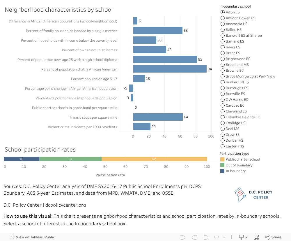
Anyway, the DC Policy Center has a really cool graphic regarding in-boundary schools on one of their blog posts about in-boundary and charter schools. I have strong negative feelings about their real estate related papers, but regardless, they have very nice graphics.
I was having fun but noticed the data was from 2016-2017, so I went hunting for newer data and found a bunch of ‘fun’ Excel files.
If you really want to know peoples’ values, look at what they do, and that’s been fascinating.
For school year 2017-2018 there were only 4 schools (all elementary) where over 90% of the students attended their in-boundary school. Deal Middle School, the school Mayor Bowser referred to when promising Deal for All, only had 78.9% of the students in the boundary. Deal is also the largest middle school in the city. It is more than three times as big as the next biggest middle school and twice as big as most education campuses, which mix middle and high schools. But abut 20% of students who could go to Deal, the best DCPS middle school, their parents decided, “nah, we’ll pass.”
What’s up with that?
I was having fun looking at the percentages of different schools from the DC Policy Center data and then looking at the 2017-18 Public School Enrollments per DCPS excel sheet. The weirdest thing, I thought, was with schools where a majority of the students came from the boundary but most of the kids in the boundary went to other schools. And those other schools weren’t necessarily charters. It’s like parents saying, “we believe in public schools, just not the one we’re assigned.” And when some lose the school lottery, they move.
The neighborhood school would be the in-boundary school, not necessarily the nearest school. Looking at the excel sheet I mentioned above, if 10 or more students attended a public (DCPS/charter) school other their in-boundary school it was listed. There are some kids in the Seaton boundary going to Cleveland and Garrison elementary. But those are only about a dozen or so kids per school. In the Dunbar boundary, a chunk (total Dunbar enrollment 617) of 128 attended McKinley Tech and 109 attend Wilson. McKinley isn’t that far (by bike) from Dunbar and from what I can tell a huge chunk of kids in the Dunbar boundary make up the student body (128 out of 620). Considering the huge portion of Ward 5 Dunbar’s boundary consists of, McKinley might be closer, since it is further east. Also considering Ward 5 is served more by the red line, you may as well stay on the train for a Wilson, in the middle of the Van Ness and Friendship Heights stations at Tenleytown.
I’ve mentioned that I’m agnostic when it comes to DCPS, but I get the idea of the neighborhood school. I get the idea of kids from the neighborhood going to school with other kids from the neighborhood. But only Mann, Janney, Key and Lafayette have a 90% plus neighborhood participation rate. When I look at where the kids in the Seaton boundary go, majority go to neighborhood charters or nearby DCPS schools. So they are sorta kinda still in the neighborhood.
Okay, I need to regularly post this topic. Because DC is a city that attracts people from elsewhere, the nuances of the city’s history get lost over time with each new fresh face.
There is a piece in the Washington Post, a “Where we live” real estate article about Truxton Circle. There is a line that refers to other neighborhoods, Bloomingdale and Shaw. I’m only going to nit pix here and state, once again, Truxton Circle is in Shaw. I thought I mentioned it to the writer to reached out to me for contacts, when I warned her about the group of residents who hate the name ‘Truxton Circle’.

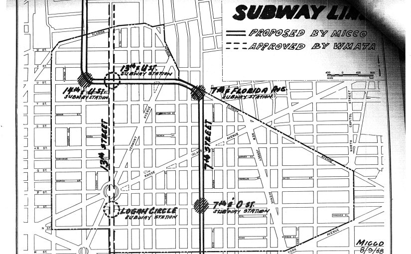
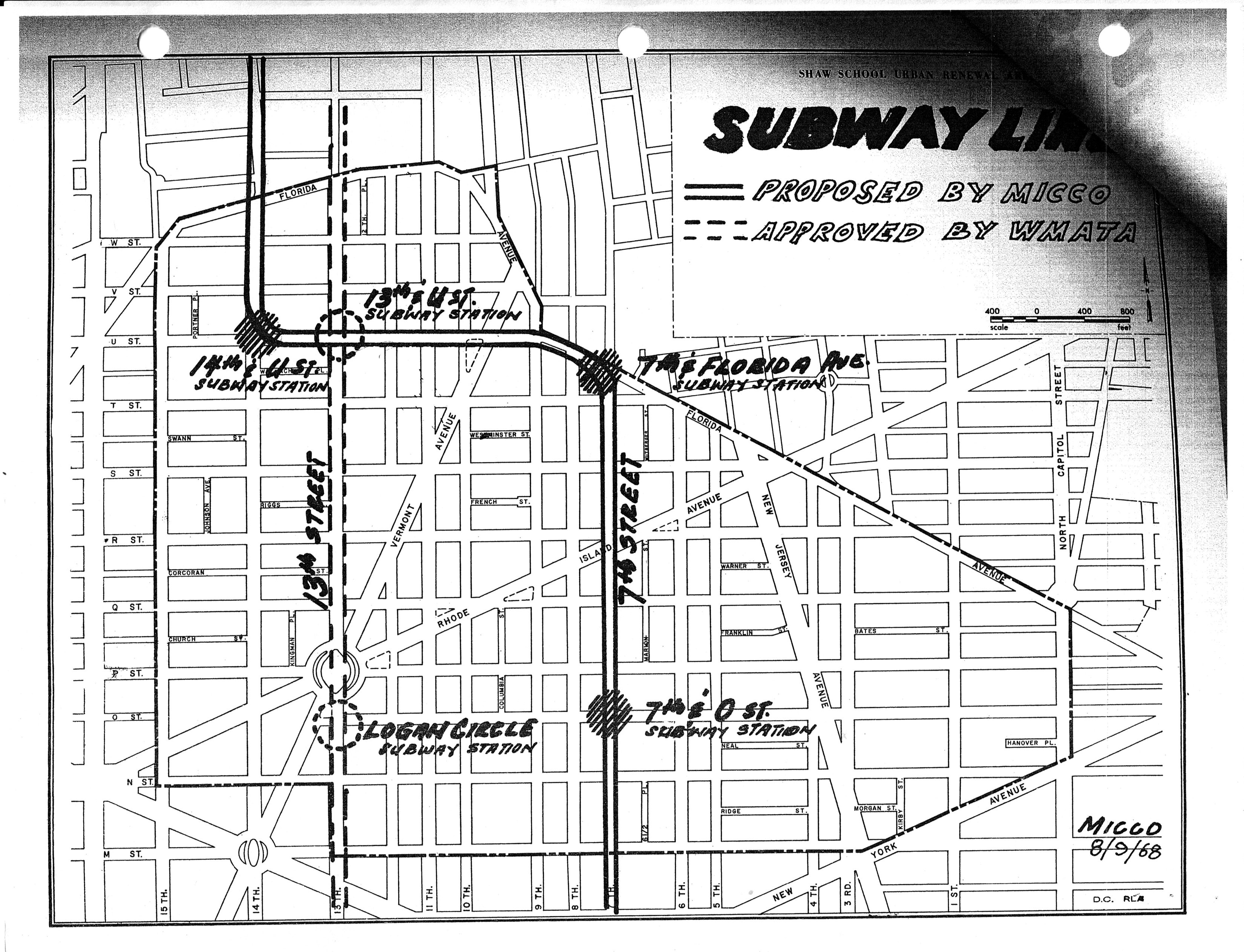
Look at this map above. Let’s point out a few of the neighbhorhoods covered by this circa 1968 map of the Shaw School Urban Renewal Area.
U Street
Let’s start in the north with the top of the map where we have the area currently known as U Street. Formally this was the city’s Black Broadway. What are the boundaries? Beats me. Let’s say U St and Florida Ave NW.
Truxton Circle (most)
Coming over the east in a clockwise direction, we have the NW section of Truxton Circle. There is a NE section that I ignore most of the time. That north east section is not part of the original Shaw neighborhood.
Mt. Vernon Square (part)
Funny thing, there are parts of Mt. Vernon Square, or at least the Mt. Vernon Square Historic District (map, PDF) in Truxton Circle. And there are parts of Mt. Vernon Sq. outside of Shaw. This is in the southeastern part of Shaw and bordering Shaw. There is an overlapping. Don’t freak out, it’s okay.
Mid-City
Now this is the section that these days gets touted as the current boundaries of Shaw, although I don’t know who redrew them. Mid-city contains within it, the small historic districts of Blagden Alley and Naylor Court. It also has the most awesome restaurants.
Logan Circle
Finishing our loop around Shaw is Logan Circle to the west. According to the Logan Circle Community Association the boundaries are: “S Street to the north, K Street to the south, 9th Street to the east, and 16th Street to the west.”