55 P St NW- bad rental in 1923

photo of property

I’ve been reaching into the pile and today I have a letter from 1923 regarding poor living conditions at 55 P St NW in the TC. The initial letter was from Walter W. Brown who wrote to the Rent Commission. The Rent Commission responded to him about paying rent but did not address the living conditions.

Feb 19 1923 Letter RE 55 P St NW by Mm Inshaw on Scribd

The Brown family appears in the 1920 census. We find Mr. Walter W. Brown, a 49 year old African American driver, living with his wife Lizzie, and their minor sons and daughter, adult daughters and one son-in-law. They are renters.

In the letter Brown writes that he lives a 55 Pea St NW. People did cute things like that, calling Q St, Que St, I St, Eye St, and the like. I hadn’t seen anyone call P St Pea St before. Anyway, at 55 P St, the plaster was falling down in various parts of the house, there was no septic and the stove was broken.

Mr. Brown mentions a Mr. Schwartz at 724 15th St NW. I checked the 1923 city directory and the inhabitants of that address was Schwartzell Rheem & Hensey Co. a real estate company. Were the realtors or property managers letting the house go to pot so they could get rid of the renters, rehab it and rent it at a higher price? I don’t know.

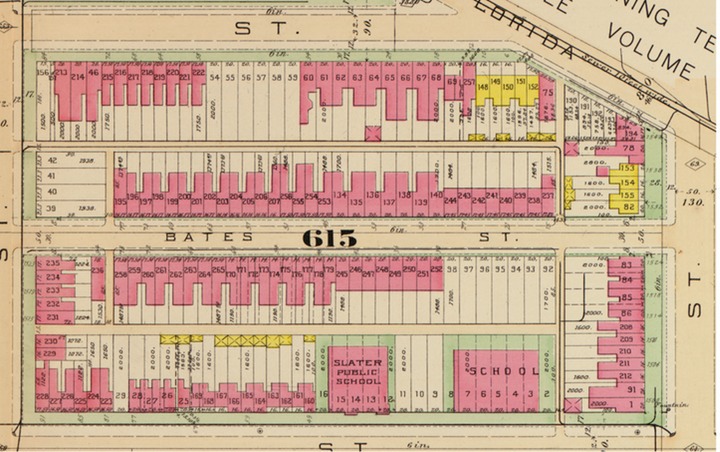
According to the Tax Assessment office, what is currently at 55 P St NW, was built in 1924. I could only find one permit for that lot pre- 1958. The earliest record I can find for Sq 615 lot 163 is from 1944. That was when Fred D. Geisler purchased the property. So it could be a completely different house.

I checked the Library of Congress to see if the lot number changed. The 1919 map shows lot 163. where lot 163 should be, with a brick house on it.

So that’s that.


Property Owners of TC- Harry L. Black

This was an earlier post, but I noticed it didn’t have an address.

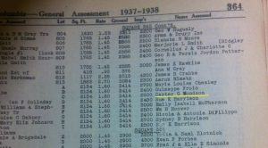
So today’s owner from the 1933-1934 General Assessment snippet for Sq. 551, the block the NW Co-op and Mt. Sinai sit, is Harry Black (1884-1945). According to the snippet he owned lot 859. But a search of the Recorder of Deed records show he owned lots, 144-148, 154 and 155, which he bought from Dennis Lawrence of NYC in 1931. He also bought lot 218 from Warren F. and Maud G. Brenizer in 1922. Then other lots, 156-157 from two separate people in 1926. Lot 182 from Allen C. Clark in 1927. Lots 149-153 from William and Adelaide E. Muehleisen.

Lots 144-157, 191, 218-219 were alley facing properties, so I have no street for it.

Image not found

Lots 182, 224, 226 and 227. I can’t find them on the 1919 Baist map.

Lot 221 was on 1st St NW, but the number was somewhere between 1618 and 1630 1st St NW.

So what do we know about this real estate mogul? Harry Leslie Black was born in MoCo, married to Nora Elliot (1881-1955), and as far as I can tell had no children. In the 1930 Census he’s a Dairyman, working for a dairy. So when he sells many parcels (more than listed above) of land to Fairfax Farms Dairy, Inc. it makes sense. He was listed as a proprietor in one census, so was he bought out? Was he planning on retiring from the dairy biz anyway? Was he an investor in Fairfax Farms Inc?

In an earlier version of this post I wrote that the Blacks lived near Truxton Circle, in Bloomingdale, at 52 Adams Street NW. On this go around I found him at 108 Florida Avenue NW when he was registered for the World War I draft. Sometime after Harry retired they were living way up near Friendship Heights at 3640 Fessenden St. NW, when he registered for the Second World War draft.

We’re getting close to the end of this series. Well maybe a season. I will get back to Black Homeowners of the TC and focus on 1930 and 1940 home owners.


Black Home Owners of TC- George W. Turner

In the 1920 census George W. Turner lived at and owned  218 P St NW (Sq. 553, lot 0089). He was (Culpeper) Virginia born carpenter who lived with his wife Lizzie B.(nee Wallace), his nephew William T. Turner and brother in law Moses J. Woods.
photo of property
The land records have him purchasing 218 P St NW in 1922 from the survivors of Herbert A. Gill. Then not a whole lot happens. It appears that Turner did not borrow against the house. There is a document in 1922, then the next record is from 1954, when he sells the house to pool hall owner Harvey Washington Banks and his wife Nettie Lee Jackson Banks.

Prior to 218 P St NW he lived at 1026 New Jersey Avenue NW with his wife and nephew William T. Turner in 1910. Before that, according to the 1900 census, he and Lizzie lived in Culpeper, VA with their 11 year old daughter Rosa and brother in laws Major J. and Russell Wood. In May 1898 he married Lizzie in Alexandria, VA.

He was living with his wife and other relatives in the 1920 census. In 1930 he was listed as a widower and was just him and his brother in law, Moses. In 1930 he was 60 years old and like Jesus went from carpentry into ministry. The next census, the 1940 census, he did not list any occupation. His brother in law was replaced by a family of lodgers, the Hensens of Pennsylvania, Virginia, and New York.


1957 Church Survey: Mt. Airy Baptist Church- Rando Church Not in Shaw

This is part of a series where I look at churches that were surveyed in the 1957 Northwest Urban Renewal Area Church Survey. No other survey has been done since.

Today’s entry is Mt. Airy Baptist Church currently at 1100 North Capitol Street NW, was in 1957 at 17 L St NW… which is kinda where the building sits. It’s not in Shaw, it’s over in the NoMa area.

It still is, and was then, an African American church. It was a large church with about 1,300 members. They had a large under 18 population and the majority of the members were white collar workers. About 40% of the members lived in the Northwest survey area, whereas the 60% majority lived in other parts of the District.

CS 5 Mt Airy Baptist by Mm Inshaw


Black Home Owners of Truxton Circle: James R. Clark

Hey, another waiter from 1920.

photo of propertyJames R. Clark was listed in the 1920 census as a widower waiter living at and owning 238 P St NW. But according to land records he didn’t get the property in his name until 1922. The land records are a little confusing.

There a deed from 1922 transferring Sq. 533 lot 0102 from other tenants at that address to Mr. Clark. Document #192206230090 dated June 23, 1922, transferred the property from Alberta Cunningham, Harry F, Dorothy, Marie and Robert C. Kendrick, Blanche and John J. Lynch to Clark. Alberta and her husband Warren Cunningham were also at 238 P St NW in the 1920 Census as renters. Mr. Clark’s roommate was Robert Kendrick.

The land records only go as far back as 1920-1921. There is proof that James Clark lived in the neighborhood before 1920. His 1917/1918 World War I draft registration had him living at 238 P St NW with his wife Mary M. Clark and working at the Harrington Hotel.  The 1914 and 1915 city directories have him at the same address, as a waiter. Prior to that in 1910, he was at 415 U St NW.

His ownership seemed short lived. Later that year in December of 1922, Clark sold the property to William T. Overhall. In the 1930 census, William T. Overhall is listed as the African American owner of 238 P St NW. And like James R. Clark, he too was a waiter.

That Martin Luther King speech I could never seem to locate

Around about the early part of the year I go pecking about looking for the speech Rev. Martin Luther King Jr gave in Shaw. And I can never find it when I look. Poster-For-MLK-Parade

Today I was looking for a 1957 Church survey for a church that was at 1520 3rd St NW. But I can’t find that, but when I was looking for it, guess what I found? Yes, the King speech.

It seems it was part of a newsletter published by MICCO (Model Inner City Community Organization) run by Rev. Walter E. Fauntroy from 812 S St NW, which is New Bethel Baptist Church. As you can see from the above flier, Dr. King had an event in Shaw on March 12, 1967 and the newsletter was published the next day.

DC History Shaw MiccoNews MLK by Mm Inshaw on Scribd

Sorry for the quality of the copy. On the second page the first couple of words in the last 4 lines of the last paragraph are:

city. The
problems of crime
the people there to
that businessmen must

I’ll still look for that church survey…..

Black Home Owners of Truxton Circle: Frederick B. Turner

Currently 244 P St NW is the Phanelson Memorial Apostolic Church. I took a quick look at the 1957 Church Survey and this structure was not a church then. But back in 1920 (or maybe before) it was the home of Frederick B. Turner, an African American waiter, and his family.Looking at Sq. 553, lot 99 records it looks like Frederick Booker Turner and his wife Irene Amelia (nee Malone) borrowed money in 1921, 1924, 1932, and 1947 using their home.

In 1920, Frederick Turner lived at 244 P St NW with his wife, lived with their daughter Geneva V., sons Leon Lovelace and Leonard Frederick, and his brother I Garland Turner. In 1930, the family household included Mr. Turner’s mother Annie Shade Turner, a new son Frederick (Jr?) and daughter Antionette Mae (side note- she wound up marrying 4 times by 1978). By 1930 it appears his brother moved on. Another, very slight change, Mr. Turner went from being a waiter at a hotel to being a waiter at a restaurant.

Mr. Turner died in December of 1966 according to the Social Security death index, somewhere in the 20010 zip code. Mrs. Turner died April 13, 1978. He seems to disappear after the 1930 census. He pops up in 1941, and is still a waiter, but we get the name of the restaurant where he worked.

In 1947, the Turners sold the property to Ernest Clinton Winfield, a Black native Washingtonian, after paying back their debt to the Washington Loan and Trust Company. Mr. Winfield borrowed $7,500.00 from the same institution when he purchased the property.

Black Home Owners of Truxton Circle: Emma Ashton

Note- This was sitting in my draft folder. I don’t know why. It’s probably lacking some information, but I don’t know what.

Mrs. Ashton lived at 1405 1st St NW in Truxton Circle. She was not the only person to live at that address in 1920. I count about 14 people living there. It’s a modest house, so I’m not sure how one could crowd 5 households of that many people in that house.

Mrs. Emma Ashton, an African American widow of Ludwell Ashton had lived at 1405 1st St NW since 1900. In the 1900 Census she’s at 1405, living with her 75 year old widowed mother Adeline Brooks, who was the owner, her husband and their sons, Kellogg B. and Leonard A. Ashton. In 1920 the roles had changed, Emma was the head and the owner and her then 93 year old mother wasn’t.

Emma Ashton does not appear long in the Recorder of Deed’s records. There are several financial records for 1922, which aren’t particularly clear to me. She could have extended some loans, but I’m not sure. This period lasted between 1922 and 1924. It appears that she lost lot 11 (on Square 616) in 1934 and lot 816 in 1929.

Looking for an Emma Ashton for all of DC uncovered other property she owned in Truxton Circle, 302 Florida Ave NW (0519-0072) and 14?? 1st St NW (0553-0122). It appears she sold the property on 1st St in 1922 to Gertrude E. Holmes.

1957 Church Survey: St. Paul the Apostle

Once again, this is a church that no longer exists, on lots that no longer exist. St. Paul the Apostle sat at 15th and V Streets NW. It’s campus was on Square 203, lots 800, 801, 802, 803, 806, 807, & 808. The only one of those lots that still exists is 806.photo of property
Maybe in the future I will look into when the diocese decided to close or rename it, as St. Augustine sits there now.

St. Augustine is a primarily African American Church. St. Paul was a majority White church, though there is mention that Blacks attended mass in the 1957 church survey.

St. Paul the Apostle’s 1957 demographic information leaves much to be desired. The membership was around 1200 but what were their occupations? Eh, mainly the government. What was the age range? Eh, middle aged? What the heck is 1957 middle aged? It changes depending on how long people live. The geographic info is based on parish boundaries, which most people these days ignore (myself included). The boundary for St. Paul the Apostle was 20th St NW (a bit of Dupont/ Adams Morgan), Girard St NW, 7th St NW, and Q St NW.

Anyway, here’s the 1957 survey page:

CS-56-St Paul the Apostile by Mm Inshaw


Police of Truxton Circle- Thomas Lawlor

Here’s a quick story of Thomas Lawlor. In November 1882 Ofc. Thomas Lawlor, an Irish immigrant, who lived on 4th St NW in Truxton Circle, was at work and fell ill. Then he went home, and died.
Thomas Lawlor lived at 1618 4th St NW with his wife Ellen, and their two children Daniel and Mary in 1880.

The 1880 census didn’t ask if people were owners or renters. I only discovered that Lawlor owned the property because I was searching for the newspaper announcement that he had died. In addition to finding his funeral arrangements, I found a mention of a real estate transfer.

Sept 9, 1878

For some reason Thomas Lawlor, the resident of 1618 4th St NW in 1880, sold/ transferred the property (0509E-0053) to James Lawlor in 1878. I don’t know if James is a relative.

Nov 15, 1882

It seems to be a very Irish thing, of that time, to have something at the home of the deceased. It appears they departed from 1618 and made their way to Immaculate Conception Catholic Church. I wonder if the German George Glorius and his family, one block over, joined the procession? The Glorius family also attended Immaculate, which from personal experience, is a 15 minute brisk walk away from 1618.

There is very little of interest in his personnel file (see https://catalog.archives.gov/id/145835884). He seemed to have wandered into a grocery on North Capitol, where he wasn’t supposed to be, and was written up for it.