Old Streetcar route: The Fourth Street Line

From Rider’s Washington, 1924.

Fourth Street Line: operates between Steamboat wharves (M and Water Sts., S.W.) and W St. and Georgia Ave., N.W. Route: northwest on Water St. to 11th St., north on 11th St. to Virginia Ave., northwest on Virginia Ave., to B St., west on B St. to 14th St., nort on 14th St. to G St. N.W., east on G St. to 5th St., north on 5th St. to New York Ave., northeast on New York Avenue to 4th St., north on 4th St. to Florida Ave., east on Florida Ave., to 3rd St., north on 3rd St. to Elm St., west on Elm St. to 4th St., north on 4th St. to W St. to Georgia Ave.
Car signs: northbound, “LEDRIOT PARK”; southbound, “WHARVES.”

Is it just me or does that sound like a screwy route?

Old Streetcar Routes

Well I’m back from the annual trek to Florida to see the family, and since I’m catching up on what’s been going on, here’s some history.

From Rider’s Washington, a tourist guidebook from the 1920s, there is a description of the different streetcar lines. I’ll mention a few here.

Florida Avenue Line: operates between Stephenson Monument (Pennsylvania Ave. and 7th St.) and Navy Yard Gate. Route: north on 7th St. to T St., east on T St. to Florida Ave., southeast on Florida Ave., to 8th St. N.E., south on 8th St., to Navy Yard Gate (M St. S.E.). Car signs: north and eastbound, “NAVY YARD”; west and southbound, “7TH AND PA, AVE. N.W.”

New Jersey Avenue Line: operates between Rock creek Bridge (20th and Calvert Sts. N.W.) and Navy Yard Gate (8th and M Sts. S.E.). Route: east on Calvert St. to 18th St., south on 18th St. to U St., east on U St. to Florida Ave. to New Jersey Ave., southeast on New Jersey Ave. to Massachusetts Ave. to Union Station, thence southwest on Delaware Ave to B St. N.E., east on B St. to Pennsylvania Ave., southeast Pennsylvania Ave. to 8th St., south on 8th St. to Navy Yard.

The Washington Railway and Electric Company was another (I don’t have it in my notes who operated the above lines) streetcar company in DC. Their Georgia Avenue-Ninth Street Line had four lines. Line A went from Forest Glen to Water St. going down Georgia then down 9th. Line B went from between the Wharves to Ga Ave and Eastern Ave. Line C went between Water St to the Soldiers Home. Line D went between Takoma, Anacostia and Congress Heights. It started at Butternut St in Takoma to GA Ave and went along the same southern route as Line A to 4 1/2 St to Maryland Ave to B St and Canal Sts. then east on E, south on 4th, then east on G, then south on 11th to Anacostia Bridge, then south on Nichols Ave to a terminal at Talbert St. From Talbert on Nichols Ave to Congress Heights and west on Portland St to Steel Plant, The names of the streets may have changed because the directions seems odd once you get past the Anacostia Bridge, which could be (I dunno) the Fredrick Douglass Memorial Bridge.

Later the Fourth Street Line.

Armstrong, New York Ave, and neighborhood charity

Those two have nothing to do with each other except they are the emails I have flagged in my inbox.
First Armstrong. I guess I’m on the mailing list for this subject because I attended the BACA meeting that covered it and I guess this is the ‘getting back with the community’ part of that discussion. Anyway here was the notice that was sent out:

Dear Community,
On Thursday, February 19, 2009 at 7:00 pm at Armstrong School, Kent Amos, founder of the CAPCS education campus, will met with community for follow up discussion on his recent decision permitting Metropolitan Baptist Church use of the school for Sunday services. Senior Pastor Beecher Hicks also plans to attend. Please make every effort to come out and bring your questions and alternative ideas for addressing this community dilemma.
Light refreshments will be available. For further information, please contact me at 55O-O619* or by e-mail at adbonds g mail com*.
I’m looking forward to seeing you,
Anita Bonds

There have been a couple of ‘reply all’ emails concerning the upcoming meeting. One, going on the separation of church and state thread is a fruitless one. The relationship between the charter school and the church is that of landlord and tenant and not unusual. My best friend’s church rents out a PG County high school gym while they wait for their building to be done. Difference? High schools have way more parking than middle and elementary schools. And it is the parking that has raised the immediate resident’s ire. Second, sticking to the point of the matter, parking, and using the threat of strong parking enforcement may prove fruitful.
This weekend being so nice I rode my bike to church, taking my old route by the old location of Metropolitan Baptist. I could see the difference. When Metropolitan was on R Street, the streets were congested and there was almost ALWAYS someone blocking the bike lane. And the Washington Post newspaper vendor dude used to be on the corner. But no more. The streets around 13th and R were ‘normal’, no more crowded than 9th and R.
New York Avenue. It is websites like Stimulus Watch that make me think that the net was made for democracy. Apparently, the intersection at Florida and New York Avenue is to take up 8 millllllllyon dallahs. There is another New York Ave project also included but no detail of what NY Ave bridge. Anyway, I need someone to define ‘shovel ready.’ Seriously there must be a treeful of paper of studies on New York Avenue NE and NW and it’s various intersections that have never gotten past ‘oh look we have a study.’ After looking at the guts of some road studies (not New York Ave but other DC roads), the info in them goes bad quicker than a gallon of milk, which means after a few years…… you do another study (and the contractors who do studies say yay!). Seriously define ‘shovel ready’ because if it involves a study and community buy in and the other things that take up time and effort, it’s only shovelin’ manure.
Lastly, something good from the Eckington listserv:

Hi Neighbors,

Thank You!!! When members of our community were in need of support their neighbors stepped up to help out. The Stancil family has found an apartment to live in until repairs to their home are completed. Our efforts to raise funds and provide clothing was a great success. The community members, area churches and strangers that happened to read about the Stancil family at the Big Bear Cafe contributed $2,000 in cash, checks and gift cards. I had to make daily trips from the Big Bear to Emery with my Outback stuffed full of clothing donations. The Stancils were overwhelmed by the out pouring of support when they needed it the most. Any clothing the family can’t use will go to area clothing banks. We all face uncertainties with the economic crisis yet this community opened their hearts to help. Thank You!

we all work together, ted

*I made changes here.

More than just transportation

Yesterday I got an email about something I heard about on the radio this morning. The Terwilliger Cost Calculator is part of the Urban Land Institute’s Terwilliger Center for Workforce Housing with the Center for Housing Policy and the Center for Neighborhood Technology report “Beltway Burden: The Combined Cost of Housing and Transportation in the Greater Washington, DC, Metropolitan Area.”(PDF)
I played with the calculator. I had to use the Internet Explorer version despite being in Firefox. I plugged in different areas, Shaw, Riverdale, Arlington, and the far reaches of Alexandria. Except for Arlington where the income was higher, most other places had the transportation/housing costs to income around 50% or higher.
Yet in past conservations with co-workers, though housing costs are cited as one reason for moving far out, there are other factors at play.
These factors include spouses/partners who don’t work in the metro center, but out in far reaches of Fairfax, Bowie, and Baltimore. They include large dogs, whom the owners believe need a large yard. A desire for a school system you don’t have to think about. And a desire to live in a setting like the one they left back home. Problem is with this area, the house with lot that is average in St. Pete, FL is expensive in Rockville. The other problem is a lot of us aren’t from here and trying to re-create the familiar here is pricey.

Inaugural WTF?-Truxton Circle Lockdown


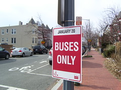
Buses Only Jan 20
Originally uploaded by In Shaw

Please, someone say this sign was erroneously placed. This sign is at 3rd and R Streets NW.
I did find a new map (PDF) at the DC government’s inaugural site that gives the impression that there is charter bus parking up here, which may or may not explain the sign. But if it were for charter bus parking then there aren’t any no parking signs, which makes me think this may restricted to buses (ie excluding cars).

Inauguration Musings- Intra/Inter-city mobility

I was chatting with an older woman who lives in SW and she was planning on visiting an elderly bedridden friend in upper NW to watch the inauguration on TV. Question is, how easy, or hard will it be to get there?

Spoke with the Aunt. She will be having guests over for the inaugural weekend and Shiloh Baptist is having a slew of activities, some of which they’ll be attending. I asked how was she going to get there. Drive. Well it will be the weekend, and not the day of, so maybe that will work. Asking about the actual day, she’d rather be home, but, she’s got guests. I suggested dropping them off at the PG Plaza station, handing them a map and wishing them the best. No, not an option. She plans to drive in on New York Avenue, and either travel along P or Rhode Island to get to the parking garage at her work not far from Dupont. Yeah, I don’t know how that’s going to work out. I did tell her that the City and everyone else is discouraging car travel and suggesting the metro. Nope, not an option. Argh!

Inauguration Musings- Blocked Streets in Shaw?

I’m looking at the press release put out by the inaugural people (PDF) and on page 8 it says that 13th St NW from K to Logan Circle and 6th Street from K to P Streets NW will be pedestrian-only for the parade. But I don’t see any time stamp for parade only stuff. So…. how long will cross streets, and I’m going to guess that the 600 to 1200 blocks of O, N, M and L Streets are going to be blocked? Because if those North-South routes are going to be pedestrian only per the press release, what of the East-West Streets that intersect them? Also those pedestrian only routes don’t show up on any of the maps I’ve been looking at.
-UPDATE-
From the DC.GOV inauguaration site I noticed:

The following roadways will be closed to traffic from Tuesday, January 20th, 12:01am through Wednesday, January 21st, 12:01am, to implement and remove the Charter Bus Parking zones. The Road Closure areas will be limited to charter buses, metro buses, taxis, postal vehicles, law enforcement vehicles, emergency vehicles and residents with government issued identification or vehicle registration showing residency inside the restricted area.

I’ve picked out the ones of interest to Shaw residents:
I-395/3rd Street Tunnel from SE/SW Freeway to New York Avenue
13th Street, NW from K Street, NW to Logan Circle, NW
6th Street, NW from K Street, NW to P Street, NW
13th Street, NW from Logan Circle to K Street, NW
14th Street, NW from R Street to K Street, NW
15th Street, NW from K Street, NW to Rhode Island Avenue, NW
New Jersey Avenue, NW from K Street, NW to Florida Avenue, NW

I’ve bolded the streets of great interest to me. It looks like a bit of the Logan Circle area is going to get caught up in this. Why aren’t these northern parts being shown on maps?

A few useful things

MPD has a crime mapping thing, that as of this morning the map feature does not like Firefox or Macs. You too can get the same thrill the police get when looking at statistics that say that crime is down. However, you are tempered by the fact that the latest victim of the theft from auto was your neighbor and the fact that there are fewer thefts from autos is of little comfort. I went down to the level of my block and discovered crime is down in almost everything, except one thing where it is up by several hundred percent.

If you didn’t notice it on the right hand side of the blog I have links to find when the next 96, or G2 is coming, which sometimes is operational. There is a NextBus for the 96, the 90, the G8, the G2, the P2, and others. Poking around I found Nextbus for PG Co.

Inauguration Musings- No bikes on Metro

I couldn’t believe my eyes when I read in the Post that bikes won’t be allowed on metro trains during the inaugural weekend. I totally understand no bikes on the 20th, but for four whole days? So I went to WMATA’s website and there it was “Bicycles also will be prohibited on the rail system from Saturday, Jan. 17 through Tuesday, Jan. 20.”
At least there is still the bus to put your bike on.

Inauguration Musings- Neighborhoods get f’d

I’m reading the Post article about transportation and the inauguration, and it looks like some close in neighborhoods are going to get screwed for three days. When I read “Neighborhood parking rules and meter enforcement in the District will be suspended Saturday through Inauguration Day,” I see a nightmare for everyone who parks on the street living within 1-2 miles of the Capitol. Tell your friends who will be crashing at your place, to carpool.
So far no one knows what streets will be closed off, and when, and how much driver chaos will seep onto neighborhood streets. Hopefully, the closures will be short lived, for a few hours. Who am I kidding? Several hours. Stock up on stuff before the crowds arrive because it will be like a marathon, Sunday church parking, and rush hour rolled into one.