Memory Lane: Billboards on New Jersey Ave


Billboards
Taken 11/15/2008. Looking north on the 1400 Block of New Jersey Ave NW

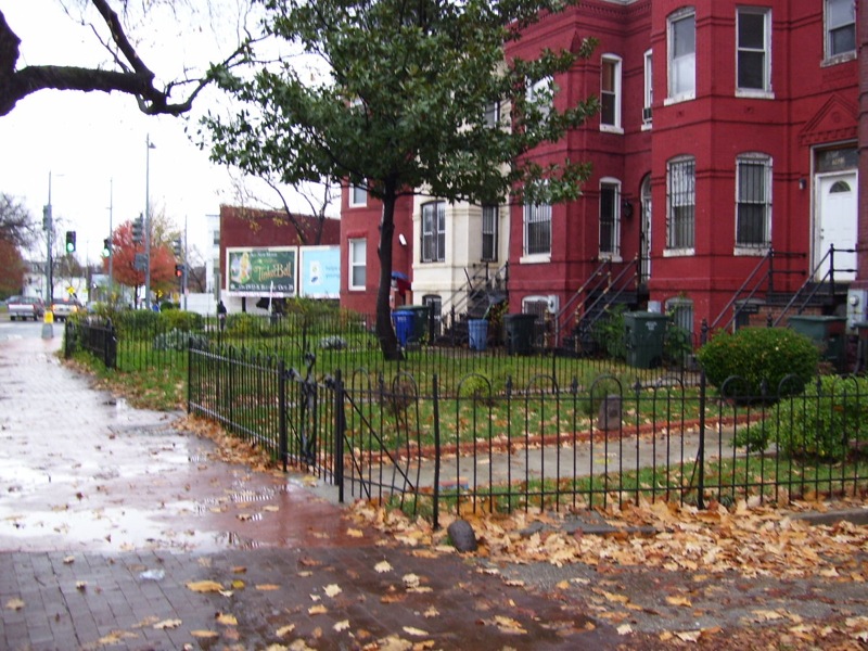
If you look where the condos at P and 4th/New Jersey NW are, there are two highway billboards. I believe one is advertising the movie Tinker Bell.

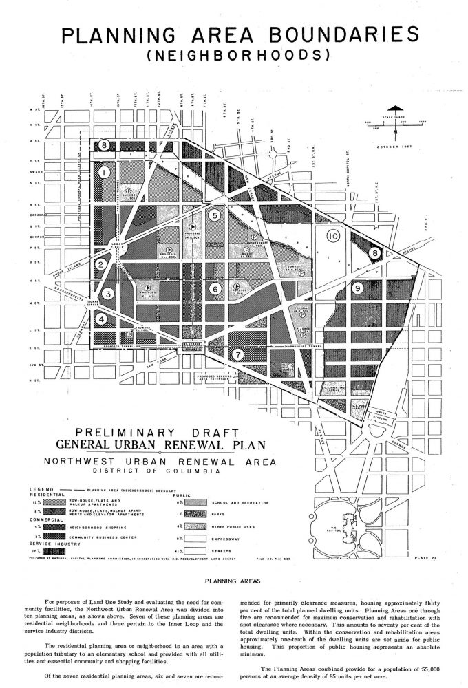
When I look back at the post Oh what could have been- a plan to destroy the TC and the map of the plan to have a multilane highway through Truxton Circle. I wonder if the billboards were placed there to take advantage of commuter traffic?

Metro: I guess I could vote with my feet, or a bike or an Uber

MetroI wonder if a third day will be the charm?

Yesterday during my commute home an old guy was panhandling on the train. He asked for change, I said I didn’t have any. I had my headphones in and was listening to a podcast, so I didn’t clearly hear whatever it was he first mumbled. But as people began filing out he said quite clearly, “I’m gonna spit in your face.” Thankfully, he didn’t and he got off the train at Gallery Place. Today it was a gang of teenagers on a crowded train during rush hour. I’ll say about 10 or so African American teens got on at Gallery Place loudly packing into one end of the train. One of them decided to throw ice, someone complained, and then they decided to push through to the other end of the train. They insulted an African American senior citizen as they pushed through. Once on the other end, they caused some commotion that at few in their party decided to film. The commotion was enough to get a few commuters, including myself, to flee the train when it pulled into Mt. Vernon Square. I reported the incident to @WMATA and MyMTPD and got back the same sort of answer I normally get when I report things.

Well, maybe I should walk or get back to biking to work instead? But the problem hasn’t been my commute in. My commute in is more positive/neutral than negative. My commute back is mostly okay but then I have 15 minutes of unpleasantness that pops up from time to time. In the afternoon I’m more likely to encounter rowdy school-kids, drunks, panhandlers, crazy people, trash, and bad smells. My work pays for my commute but sometimes free doesn’t seem worth it.

Afternoons like this make me reconsider getting a bike and cutting back on metro. I know ridership is down for various reasons, reasons being people have other options to using public transit. There are days when I could telework, but I’m not as productive at home. I could also try doing 10 hour flex-time days to limit how many times I have to come in. I’m too cheap to use Uber-pool on a regular basis. I’m still a fair weather biker, and becoming more hard-core would help me lose weight.

Anyway, there are people who are undermining public transit by adding misery to it. If the people who add to WMATA’s bottom line stop using the system, and decide to stay home, carpool, Uber, bike, walk, or drive their own personal vehicle, it’s going to take longer to get back to good.

DCist Pending comment about CaBi usage

I’m only posting this because I see a comment I made on DCist about CaBi usage is pending, and I’m not 100% sure what I wrote that would warrant a flag. Maybe saying race and income doesn’t explain everything but around here (DC) it is used to explain everything. In the case of the Capital Bikeshare race and income aren’t the major reasons in light of other information.

Looking at this image

CaBi bikeshare usage map
Image of CaBi usage and income. Note whiter areas with little to no bike share usage

So there are rich white areas of DC way west of the park where there are 0 ride per hour yellow dots. The DCist story interprets this as Capital Bikeshare failed to be available to all users because there are so few rides in Wards 7 & 8.

There are more stations in “areas with higher shares of white residents, lower poverty rates, higher income, and higher college attainment,” according to the report. CaBi’s user survey, which it undertakes every two years, bears this out. The 2016 survey found that 80 percent of Capital Bikeshare users were white, with Asian and Hispanic/Latino riders both at 7 percent, and African-American riders at 4 percent.

Yes.

As one of the 4% African American CaBi users, I’ll say there are more stations because there is more demand in my now predominately white, formerly predominately black neighborhood. I know there is lots of demand because if the morning weather is nice I need to get my butt out of the house before 7:30 or else all the working bikes nearest me are gone.  And there is lots of demand for slots near where I work, because I will encounter a full dock and try to figure out where is the closest empty dock may be.

Also if you look back at the map, the cluster of yellow is in a highly dense area with lots of retail/ jobs. The yellow along Massachusetts and Wisconsin Avenues NW into the areas of Upper Caucasia also are in dense-ish areas with retail.  What do we know about Wards 7 & 8? Not enough retail. Not enough grocery stores. Also it lacks density of say Ward 1.

If memory serves me I think I wrote that I would prefer to see an overlay looking at age and retail rather than race.

Off Label Use of Scooters

This is just an observation.
Dad and kid on electric scooter.
People are using those electric scooter things to do things probably not intended by the scooter rental companies.

Transporting your kids– As you might be able to make out from the image above is a father and son about to cross 7th Street NW in Shaw via one of those Lime scooters. This is not the first person I’ve seen transporting another person on these scooters. I see people doubling up on these often. He’s not the only father I’ve seen transporting his kids. I saw, coming at me down the sidewalk, a father with a elementary aged son in the front. Then after they passed me, I noticed another kid holding on behind the father. So, three people.
Food Delivery via Scooter
Making food deliveries– So one day on my way to satisfy my poke/poki addiction. I noticed this guy, and you can’t really see it all that well but he’s got one of those food delivery box/bag backpack things I see bike delivery people use, but instead of a bike, he’s using a Lime scooter. I don’t know what’s the story with that, or if it makes any financial sense. Did I satisfy that poki desire? Sorta, I should have ordered on-line for pick up because when it’s crazy crowded and busy, you are bound to forget one thing in the bowl you meant to get.

Well I’m glad the Shaw-Howard Station is where it is

Proposed subway line through 1968 Shaw

Sorry this is not a prettier map.

The Model Inner City Community Organization (MICCO) it appears suggested the path through Shaw the WMATA subway sorta- kinda takes. As we know the Shaw metro station isn’t at 7th and Florida, but rather a block down at 7th and S and 7th and R. The Mt. Vernon Square station, isn’t at 7th and O, but also a couple of blocks off at 7th and M. WMATA at that time, proposed the line (did it even have a color in 1968?) going up 13th Street, with a station just off Logan Circle, and the U St station sort of where the U Street station is now.

Anyway. I tried posting some Shaw history about building and growth in the post-riot, pre-non-stop gentrification period. This was based on countering a poor gentrification think piece that claimed that you could count the building projects in DC between 1968-1998 on one hand. Actually, you can count at least a dozen building projects in Shaw during that period, the Green/Yellow line, just one of many projects in Shaw. According to the wikis U Street, Shaw, and Mount Vernon Square all opened up in 1991, twenty three years after the riots. However, it wasn’t all that great in the 1990s because the Green line stopped at U Street. It would be almost 10 years before the line was as lovely and functional as it is today. I will spare you the stories of having to switch at Gallery Place & Ft. Totten to get to Greenbelt.

I’m sure the 14th Street crowd would have wished for the WMATA plan. However I’m very glad the decision to place the stations a little bit more to the east was chosen. Considering there was a significant amount of damage along 7th Street, I do wonder if the riots helped make 7th Street more attractive (cheaper land, fewer historical buildings to damage) to WMATA?

A bit of DC 60s anti-Freeway expression

The thing I like about primary sources in history is that it occasionally reminds us of the things forgotten. We know of Emmet Till, the Birmingham Sunday school children, Medgar Evers, and Malcolm X, however those other people require Googling. Yet, the people who this flyer/poster was aimed at knew who was Col. Lemuel Penn.

I don’t want to add too much to this, except to say that neighborhoods like Shaw were in real danger of being destroyed by freeways/ highways. Read the poster and tell me what you think in the comments.

Oh what could have been- a plan to destroy the TC

I watched the most recent Jane Jacobs documentary ‘Citizen Jane’, which then led to listening to podcasts about Jane Jacobs and Robert Moses. If you are not familiar with the story, Robert Moses was a very powerful man in the early 20th century who was very good at tearing down structures (slum clearance it was called) to build parks and parkways. However, another word for parkway could be highway. Jane Jacobs was the journalist/ author/ activist who stopped him from building a road or highway through her Greenwich Village neighborhood in the 1960s.

Highways, were the big thing after World War II. Prior to the war cities were big on slum clearance. Slums, according to one definition, were places where there wasn’t a lot of indoor plumbing. But most seem to define it as where poor people live in poor conditions. You mix the slum clearance with the highway funds and you have lots of plans to destroy neighborhoods.

Proposed Highway Plan

There was a plan to extend I-395 past New York Avenue NW, where it currently terminates. The above map from 1957 shows this. There are a few landmarks to help you figure out where Truxton Circle is in all this, such as the Capitol, Union Station, Logan Circle and Mt. Vernon Square. Where you see the #10 is a white mass of something, that is a proposed expressway that was to connect I-395 to an inner loop. To create this roadway tons of housing in what is now Truxton Circle would have to be destroyed. Actually, if this were to have gone through there would not have been a Truxton Circle neighborhood.

So what happened to keep this from happening? The sixties. There was a change in the 1960s where people pushed back against the government, and this was a government plan. The culture of the Civil Rights movement played a major part in this, and that is another post for another time.

Random History- Accident at New Jersey and R St NW 1980

So this is random.

First page of Lawsuit
Civil Action No80-2789

So I was going through some court cases, don’t ask why and happened to have noticed this thing. It is a lawsuit for a traffic accident that occurred at New Jersey Ave and R St NW on the border of Truxton Circle.

According to the first page at around noon on October 14, 1980 A Ms. Hodges was trying to turn onto R Street from New Jersey Avenue NW when she claims that a van for Budget Lock and Key hit her and sent her into the northbound lane of traffic.

This is not news, and it is questionable if it is history. But if there is a friggin plaque on the 1500 block of 4th Street documenting a one time rec center, heck I can write about a traffic accident.

The notable thing about this case is that there are depositions, oral histories of sorts,  and one is from someone from the mosque on 4th Street. I glanced over that deposition and I’m not sure what he had to add to the case. The problem with some voices from the past is that they don’t always have anything all that interesting to say.

Light Rail- I want to pay, but can’t – In Shaw – Mari in the Citi

Dear Baltimore,
I would like to pay for my rides on your light rail. I’ve noticed your signs saying I should pay and how much the rides cost.
However, there is no place for me to slap my CharmCard or even my SmartCard (’cause in DC we’re a bunch of brainy know-it-alls) on the rail.
BmoreLight RailOne can enter through front, rear and middle doors, and I’ve not seen a card reader at any of these doors.
I’ve even looked for card readers at the station stops, and I haven’t seen nary a one. But I have seen the signs and the ticket dispensers, which is the same machine I can add funds to my CharmCard.
I have asked the few people who I know who live in your lovely city about paying for rides on the Yellow Line, and they don’t know either.
I’m sorry you did not get funds for your Red Line, possibly at the cost of the DC Maryland suburbs getting the Purple Line. If I know one thing, when the Purple Line gets working, it will get some busy lines connected. Now if Virginia would only create a crescent to connect their silver, orange, blue, yellow lines and in my fantasy world, Maryland’s red or green lines, that would be wonderful. But enough about DC.
Your yellow line is great. It connects Penn Station (I tend to walk to another station that’s about 3-4 blocks away) to Camden Yards to BWI (or WMATA’s B30 bus as far as I care). It connects several of your assets, it has value. Is it worth it for you to put in a card reader?
Thanks,
Mari