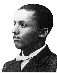
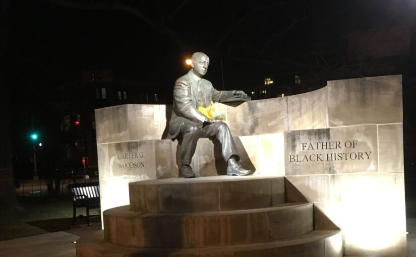
Black Home Owners of Truxton Circle- Ernest H. Saulter

Image not found
1919 Baist Map

Today’s African American Truxton Circle resident from the 1920 Census who owned their home is a thirty-three year old express man named Ernest H. Saulter. He lived at 30 P St NW with his wife Ethel Willie. No children. No boarders. Just those two. The property no longer exists, and the Mundo Verde Public Charter School sits there. When it did exist, it sat across from the space between Langston and Slater schools. Prior to 30 P St NW, Ernest Howard Saulter lived at 433 Rhode Island Ave NW, and 309 I St NW, which also does not exist anymore.

A 1922 city directory shows Mr. Saulter’s business address as 30-32 P St NW. On his 1917 draft card, when he was on Rhode Island, he listed himself as being self-employed.  When looking at the Recorder of Deed records the Saulters owned lots 21, 90, and 832. On the 1919 Baist map above, lot 21 and 832 are pretty much the same lot. In 1921 Clarence M. DeVeile (not Cruella DeVille) sold the property on lot 90 to the Saulters.  DeVeile had bought the property a month earlier from Henrietta Finnegan. In order to purchase it, DeVeile borrowed $1250.00 from what looked to be the Washington Six Percent Permanent Building Association. In November of 1923, the Saulters sold lot 90 to the District of Columbia government.

Lot 21 is confusing. In the old map, it is the old number, it’s part of lot 832 and there is another lot 21 facing North Capitol Street. It’s very hard to tell what’s going on with that, so I will just look at the transactions involving the Saulters. It appears they bought the P St facing lot in 1923 from the estate of Jane Steward formerly Jane Scott. But then it appears that a month or so later they sell it to the DC government.

Looking at other Recorder of Deeds documents, Ernest owned property elsewhere too. In 1924 Ernest and Ethel purchased what could have been 609 Rhode Island Ave NW. There is a vacant lot in that space which is Sq. 442 lot 3. That same year they brought 147 Rhode Island Avenue NW (sq. 3108, lot 0003) which does still exist. The Saulters stop showing up in the Recorder of Deeds records after 1937 with a trustees deed between the Saulters and the Homeowner’s Loan Corporation. That same year the Homeowner’s Loan Corporation sell the 147 Rhode Island Ave NW to Marie H. Malvan and Mildred R. Schey for $4,750.

The last record of Ernest Saulter is in a World War II draft card. The card dates from around 1942. At that time Mr. Saulter is 56 years old. He is living at 805 O St NW, about where the Giant parking garage sits. The contact he has listed is a woman named Estelle Johnson, at the same address. This brings to question, where is Ethel? Mr. Saulter is listed as self-employed but having “defective eyes”.

1957 Church Survey- Third Church of Christ Scientist- Random Churches not in Shaw

This church used to be know for it’s fugly building.

Third Church of Christ, Scientist - Washington, D.C..JPG
By AgnosticPreachersKid CC BY-SA 3.0, Link

But this is not about the fug, this is about history. [Yes, yes, we could go on about the history of the Brutalist building that only an architectural historian could love, but I’m here for the people]. Besides, in 1957 they weren’t even at 16th and I NW where the ugly building was. No, they were at 1220 L St NW, which is currently occupied by a nondescript 1980s looking Downtown office building.

The interesting thing about this survey submission is that they say that due to their own church rules they could not provide numbers.  But they did go on to say that most of their members did not live in the Northwest Urban Renewal Area. They don’t give a racial make up of their congregation, nor an idea if they members are white collar or blue. Continue reading 1957 Church Survey- Third Church of Christ Scientist- Random Churches not in Shaw

Black Home Owners of Truxton Circle- Walter W. Dick

So here is another chapter in the series of African American home owners in the DC neighborhood of Truxton Circle from the 1920 Census. I will try to avoid making dick jokes.

In the 1920 Census Walter W. Dick lived at 70 P St NW (Sq. 616, lot 830) with his wife Eva Dick, daughters Jessie Mae and Estelle S. Dick, and a roomer T Emmett Saunders of Texas. There was another Dick at 70 P St NW, Arthur Dick who lived with his step-son Louyico Holmes. The house still exists and is currently 1380 square feet. Okay, I’m done.

William Walter Dick was born June 22nd in 1877 in North Carolina, one of four children of William R. Dick and Antoinette Pharr Dick. January 1906, in Mecklenburg, NC married Eva Irenee Caldwell. Sometime that year their first daughter Jessie was born. Two years later, Estelle was born. Then two years after the birth of Estelle, Walter was a railway porter for the family was living in DC, at 1312 G St NE.

Another view of the Dick family at 70 P St NW was with a World War I draft card. He was working for Southern Rail as a brakeman in 1917 or 1918. He last appears in the 1930 Census. Estelle is gone but they have a 4 year old daughter, along with the 23 year old Jessie, named Edna Elaine. In 1932, they borrowed $150 from an individual investor, using lots 830 and 831 as collateral. They paid it back the following year. I assumed when I checked the land records, when the property was sold in 1957 to …. Robert Weiner. Okay, the universe just want to tell dick jokes, you let the universe tell dick jokes. Anyway, as I was saying when I saw that the property was sold in 1957, I assumed Walter Dick had died. According to the deed, he was the surviving joint tenant to Eva.

Black Home Owners of Truxton Circle: Louis Bruce/Bruer

Some pages of the 1920 Census are too pale to read. There was a man we have in the TruxtonCircle.org spreadsheet listed as Louis Bauer. Since the Ancestry page for this man are too pale, I will assume, we pulled the data from a photocopy fro, the microfilm.

Image not foundSo who we believe to be Louis Bauer lived at 1405 3rd St NW (Sq. 553, lot 834) , another address that no longer exists, with his wife “TP” and their granddaughter. I have to guess it was a two flat property as there was another household at the address, but the state of the Census doesn’t provide any surname for them.

Looking at the Recorder of Deeds records, the earliest owner attached to that property was Mary F.P. Bruce, not Bauer. The initials FP are close enough to TP, as a F could look like a T, that I think the family name was Bruce and not Bauer.

There were some agreements between Mary F.P. Bruce (1854-1943), the mother, Mattie F. Tignor and a woman named Phoebe E. Tyrrell, with 3 different deeds between 1940 and 1950. There are a few more deeds and Mattie F. Tignor’s name remained on the property with another widow, Gladys F. Morse until 1961 when they sold it to Jackson Avirom, who the same day transferred it to Esther Band and her husband Robert Band. In 1963 the Bands sold the property to the DC government.

Because of the confusion with the names it is a bit hard to find information about the Bruces. In the 1920 census Louis Bruce is 72, his wife, 66 and both without occupations. However, we can find Mary FP Bruce in the 1910 city directory as a hairdresser, living at 1405 3rd St NW. A Mattie Bruce, that same year is living in NE DC as a domestic. Just looking at the other Bruces in that city directory, there is an Alex Bruce at 1405, who is a janitor. In the 1915 city director, Mary FP is still at 1405, but none of the Alexes for that year are, but Sandy the janitor is.

There are too many inconsistent items for a good search.

Church Survey 1957: Chinese Community Church

Taking another couple of pages from the church survey done back in 1957 of churches in the Northwest Urban Renewal Area, which got changed into the Shaw Urban Renewal and Downtown Urban Renewal Areas. From the book we have the Chinese Community Church at 1011 L St N.W (Sq. 341, lots 63, 64 & D). I thought this church was outside of the Shaw boundaries but it seems to be within the Shaw Historic District.

This one was unusual. This 150 member church claimed to be the only Chinese protestant church in the District of Columbia. It also appears that at the time they were in the process of building their own church building. I will guess it was their current building at 500 I Street NW. But in 1957, Continue reading Church Survey 1957: Chinese Community Church

Black Home Owners of Truxton Circle: Allen Colbert

No comment about my last post? Nada? Okay, let’s get back to boring old Black Home Owners or Mari searches Ancestry and the Recorder of Deeds and maybe some old Washington Post/Washington Star articles.

Today’s subject is Allen Colbert the contractor, not to be confused with his son, Allen A. Colbert, the driver. In 1920 he lived at 78 P St NW (Sq. 616 lot 51). The current house on that was built in 1929, according to its real estate listing, and this Colbert family does not appear in the 1930 Census for the area. Besides, the senior Allen Colbert was 60 years old in 1920, so for this time period it is too much to expect him to survive to 70. Looking at the land records, it appears that Allen and his wife Mary or Marrietta were both dead by 1924.

In a loan document from 1924, the Colbert children, Allen A., James E. Colbert and Mary Colbert Brown paid off the debt on the property to the Northern Liberty Building Association. The Colbert’s had another daughter, Julia, but she does not appear in this transaction. I’m not sure what happened in 1925, but Orwin E. Howe was tasked with auctioning off the property for no less than $2,300. I’m not sure if this was to pay off more debts or if the property was just being liquidated. Then there is nothing until 1956 after Orwin E. Howe dies (1854-1935) and according to his will the property is transferred the property to the Dr. O E Howe Home for Unfortunate Girls. *start humming Poor Unfortunate Souls from the Little Mermaid.

Prior to 1920, Allen and Mary Colbert may have lived over on Cook’s Court between 3rd, 1st, R/FL and Q Streets, NW. In that 1900 Census, their surname was transcribed as Calvert and they had two minor daughters living with them.  All the children in the 1920 Census hadn’t been born yet. In the 1909, under the name Colbert, Allen and Mary are at 1626 Cooksey Place NW. The similarities hint that this is the same family. In 1907, an Allen was at 118 Q St NW. Part of me is thinking the addresses probably moved around as much as he did.

Source: “Doctor’s Kin Gets $267,000 Estate: Provision made to Start Home for Girls.” 1935.The Washington Post (1923-1954), Dec 04, 15. https://search-proquest-com.dclibrary.idm.oclc.org/historical-newspapers/doctors-kin-gets-267-000-estate/docview/150595557/se-2?accountid=46320.

Beware of Ginger Man: A Story of Death and Sex

I was flipping through my computer files looking for something and came across a Washington Star clipping from 1878. It seems I was looking for articles mentioning George Glorius, Glorious George, of Sq. 519 in Truxton Circle. George plays a bit part in the article.

The article is about a case involving the death of a young woman who lived at 229 Q St. NW (another TC address that no longer exists) who died after getting an abortion. The article, titled “Poor Sophie Major. The mournful story of her seduction and death.” is just as click baity as mine. This was 1878, and the term yellow journalism had yet to be coined.

The red head, or ginger, in this story is John W. Hurley, a gas fitter and plumber who worked at 925 Massachusetts Ave NW….. another address that no longer exists. In the article he’s described as “tall, slender, red-haired young man, said to be somewhat “wild” in his habits….” He’s the guy who got Ms. Olivia Sophie Major pregnant. The unnamed newspaper author wrote, “Such as termination of the life of one fitted to adorn life and to be a useful member of society, seems very hard, especially when it is known that her seducer walked the streets of Washington last night unharmed by the avenging hand of retributive justice, unimpeded by the process of the law. There are crimes quite as foul as that murder, and in the eye of Heaven John W. Hurley’s soul is not free from a stain as deep of a hue of crimson.”  They published his name, where he worked, his red hair, do you think the paper was trying to rile up a mob against him? He walked the street unharmed by retributive justice, as if calling to the reader to go out and harm Mr. Hurley in the name of justice. His crime? Knocking up Olivia Sophie Major (1859-1878) and not marrying her. There was another mention in the article hinting at a desire for violence against him.

It seems Ms. Major was seen by several doctors. Continue reading Beware of Ginger Man: A Story of Death and Sex

Black Home Owners of Truxton Circle: Susan E. Brown/Berry

Today’s African American Truxton Circle resident from the 1920 Census who owned their home is the widowed Susan E. Brown of 237 O St NW (Sq. 553, lot 58). This address no longer exists, and is currently an empty lot behind the Friendship-Armstrong Charter School. In 1920 she lived there with her son William J. Brown and her daughter Alethya’s family, the Williams.

In the Recorder of Deeds’ records Mrs. Brown was also Susan E. Berry (b. 1865). She died in 1927 and according to her will, left 237 and 239 O St NW to her married daughter Alethya H. Williams, who used the property to borrow money from the American Security and Trust Company in 1934 and 1949. In 1966, Alethya sold the property to the District of Columbia.

A little thing about the will. One of the witnesses was named Ethel Witkowska, a very Polish sounding name. She lived at 21 Tea (T) St NE. She appears in the 1930 census as a 24 year old bookkeeper. According to the Social Security Death Index Ethel Witkowska was born March 1905 and died in 1974, so she was just 20 when she witnessed the will in 1925. Her name just stood out.

Another little thing about her will, is that she may have owned property in her native South Carolina. The property was in Sumter county. Since no town was mentioned, I’ll assume it was rural land.

Anywho, Susan Brown only appears in the 1920 census at that address. Susan E. Berry appears at 237 O St NW in the 1900 Census, living with her husband Hilyard/ Hilliard, a hotel porter, their sons Hilyard Jr (aka James Hilliard) and William and daughter Althea. A faulty family tree (there are a few errors) claims her maiden name was Ruffin.

Since I’m looking at the census for 1920 and her family owned the neighboring lot, let’s look at 239 O St NW. It was lot 819 or old lot 11 on Sq. 553. Susan Berry’s will had named both Alethya and Hilliard Jr. as beneficiaries for 239 O St. NW. And it is Hilliard Berry and his wife Jessie Gordon Berry mentioned in the land records, not Alethya. They borrowed several times from the Washington Loan and Trust Company and individually named lenders, in 1929, 1930, 1934, 1935, 1937, 1939, 1942, 1943, 1945, 1947, 1950 and 1953. The widow Jessie Berry sold the property in 1965 to Sylvia H. Miller, who then turned around and sold the property in 1966 to the DC government.

The Clarkes and the Stewarts lived at 239 O Street as renters. In total there were 11 people living at 239. Like their landlords, they too were African-American. The head of the Clarke family was Henry who was listed as being an Assistant Engineer. I should note that William Berry or Brown’s occupation in 1920 was that of an Engineer. William’s brother, Hilliard, in the city directory is some sort of Engineer in the DC Public Schools. According to a WWII draft card, Hilliard worked at Dunbar High School. I wonder if Henry Clarke and the Berry/Brown brothers worked together?

Black Home Owners of Truxton Circle: Harry Brown

Gee, his name may as well be John Smith. Last post was Fannie Moore and I discovered there were a bunch of ladies with that name. I suspect I’ll have to weed through several Harry Browns.

In the 1920 Census then renter Harry Brown lived at 240 R St NW with his wife Rosetta and their 5 year old, Madaline. By the 1930 Census they are owners. There was a Harry Franklin Brown at 224 R St NW who filled out the draft card for World War I in 1917/1918. Since they were both barbers, I will assume they are the same person. I did not find Harry Brown in the Recorder of Deed records, but I did find Rosa E. Brown.

The address is on Sq. 551, which has been completely redone, so none of the houses on that block remain. The Library of Congress Baist map is of little help since it does not show 240 as a house number. But I can guess that it was lot L or 837 as it was the last house facing R St after 222 R St NW. This means it could have just as well been 224 R St NW. The owner for that lot was solely Rosa E. Brown. Harry, her husband appears nowhere on the paperwork. When she sells the property in 1959 to George Basiliko and his wife, she is listed as an unmarried widow. Rosa and Rosetta are the same person. Rosa Brown appears in city directories as the wife of Harry F. Brown at 240 R St NW.

From a family tree on Ancestry we find a fuller picture of Mr. Brown. He was born on July 19, 1889 in Baltimore, MD. His father was Maltimore Brown (1856-1924) and Helen (nee Cooper) Brown (1858-??) and he had a dozen brothers and sisters. Not in the family tree is the marriage in DC to Rossetta Blackwell in 1911. But an interesting thing in the family tree which creates a mystery. One of his many siblings is his sister Mary A. (1879-1970), who around 1902 married James Boardley. In 1910 the couple lived with a then single Harry, their parents and several other siblings at 1417 3rd St NW. In the 1940 Census, Harry is living with the Boardleys. No Rosa in sight. But according to the family tree, Harry died in 1937, which makes it hard to be in the 1940 Census. Rosa Brown was living back at 240 R St NW with daughter Madeline S. Brown, widowed and working as a maid. Why were Mr. & Mrs. living several blocks apart, if he was alive at all?

Black Home Owners of Truxton Circle: Fannie E. L. Moore

I decided to make my life a little easier and just look at the 1920 census for African American home owners. That’s because the Recorder of Deeds starts around 1920/1921 and looking at 1900-1910 property and landowners is harder.

Image not foundFannie Moore is listed as living at 53 O St NW in the 1920 census. Sadly, for me, 53 O St NW does not exist anymore. Google map puts it at an alley. Looking at a Library of Congress Baist map from 1919, 53 O St NW is on Sq. 616 lot 58. However, I have to take that with a grain of salt, because sometimes these address matches are a little off. The Recorder of Deeds record #1938036439, the only record for lot 58, confirms Fannie L. Moore as the owner. In 1938, it appears she sold the land to the DC government for $3,750.

It may seem odd, but Fannie or Fanny Moore was a common enough name that several show up, living in Washington DC in the early 20th century. And it didn’t help that her birth year was inconsistent. In the 1920 and 1930 census her birth year is estimated to be 1882. But in the 1900 census, when she was a 23 year old laundress, living with her mother and siblings at 51 O St NW, her birth year was 1877. With the city directory her address jumps around. In 1928 she is at 54 O St NW and in 1906 at 51 O St NW. So I do believe I have the same woman. But around the same time period is a Mrs. Fannie L. Moore married to a Thomas A. Moore and another one married to a C.E. Moore. Our Fannie Moore was a single lady.

The O St Fannie Moore may have started her career as a laundress, a common occupation for Black women at the time, but later found work with the US government. In city directories, at least by 1906, she had found a job with the Bureau of Engraving and Printing. At one point she was a shaker then moved up to become an operator, whatever those positions are.

Once she sells her property in 1938, she all but disappears. If I wanted to spend the money, as a federal employee I could research her personnel file. That would probably tell me when she departed this earth and if she ever retired or married (thus making it harder to find her). When she sold the property, she would have been around 61 years old.