Change from 1920 to 1930, White to Black, Flynn to Keasley- 1735 NJ Av NW

I’ve been updating the blog and uploading posts from 2010. It’s slow work because I can’t figure out how to turn old Movable Type html files into a file the importer can read. Luckily I found what I was looking for in another spot.

Rosa Lee Fynn (1858-1929)

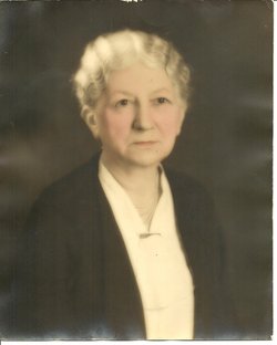
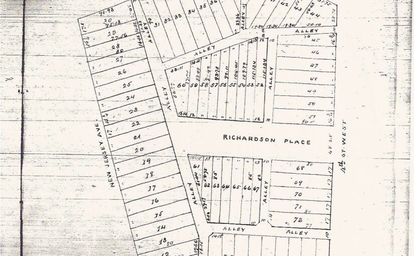
I was looking for Mrs. Flynn. In 1920, Mrs. Rosa Lee Smith Flynn rented 1735 New Jersey Avenue NW, living there with her three adult daughters, Ethel, Edna (Florence?) and Frances and two sons, George and Charles.

She was a widow at the time (1920), as her husband Zachariah Taylor Flynn  died in 1907. They had twelve children. Roley (1879-1905); George (1880-1929); Jane; Henry (1883-1969); Zachariah (1885-1961); Daisy (1887-1951); Benjamin (1888-1953/1962?); Ethel (1890-1924); Florence Edna (1892-1922); Frances (1890-1961); William (1898-??); and Charles (1899-1984).

Prior to living in the District of Columbia and Zack’s death, they were on a farm in the town of Scott in Fauquier County, VA. In 1910, she lived at 112 P St NW, in Truxton Circle. Son George, aged 29 worked as a bookkeeper for a dairy. Maybe the dairy on the 1600 block of 1st St NW? George (bookkeeper), Daisy (a dressmaker), and Edna (clerk in dry goods shop) appear to have supported their mother and younger siblings, Frances and Charles.

When we arrive at 1920, with the exception of Francis, her adult children are all working and supporting her.

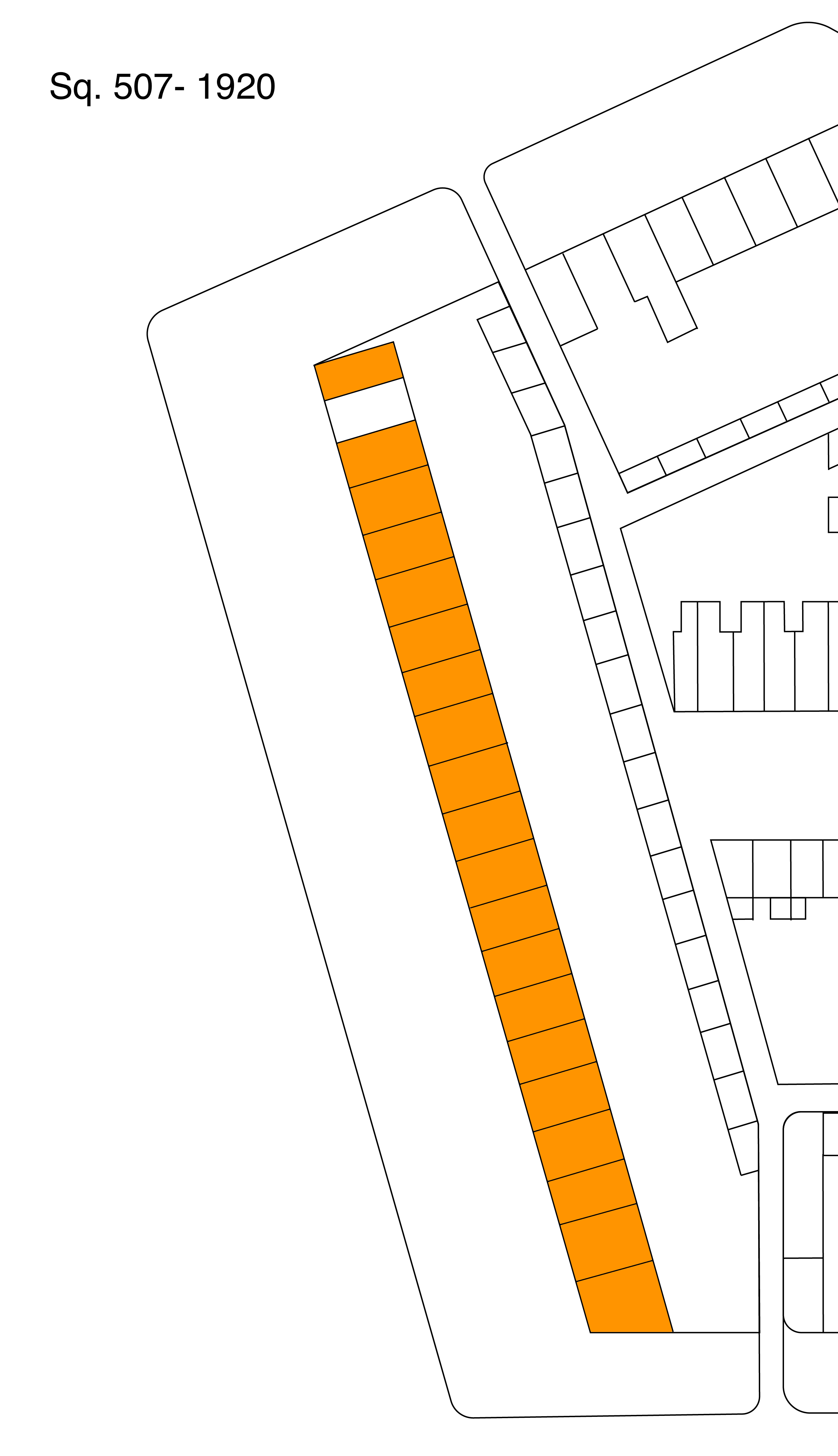
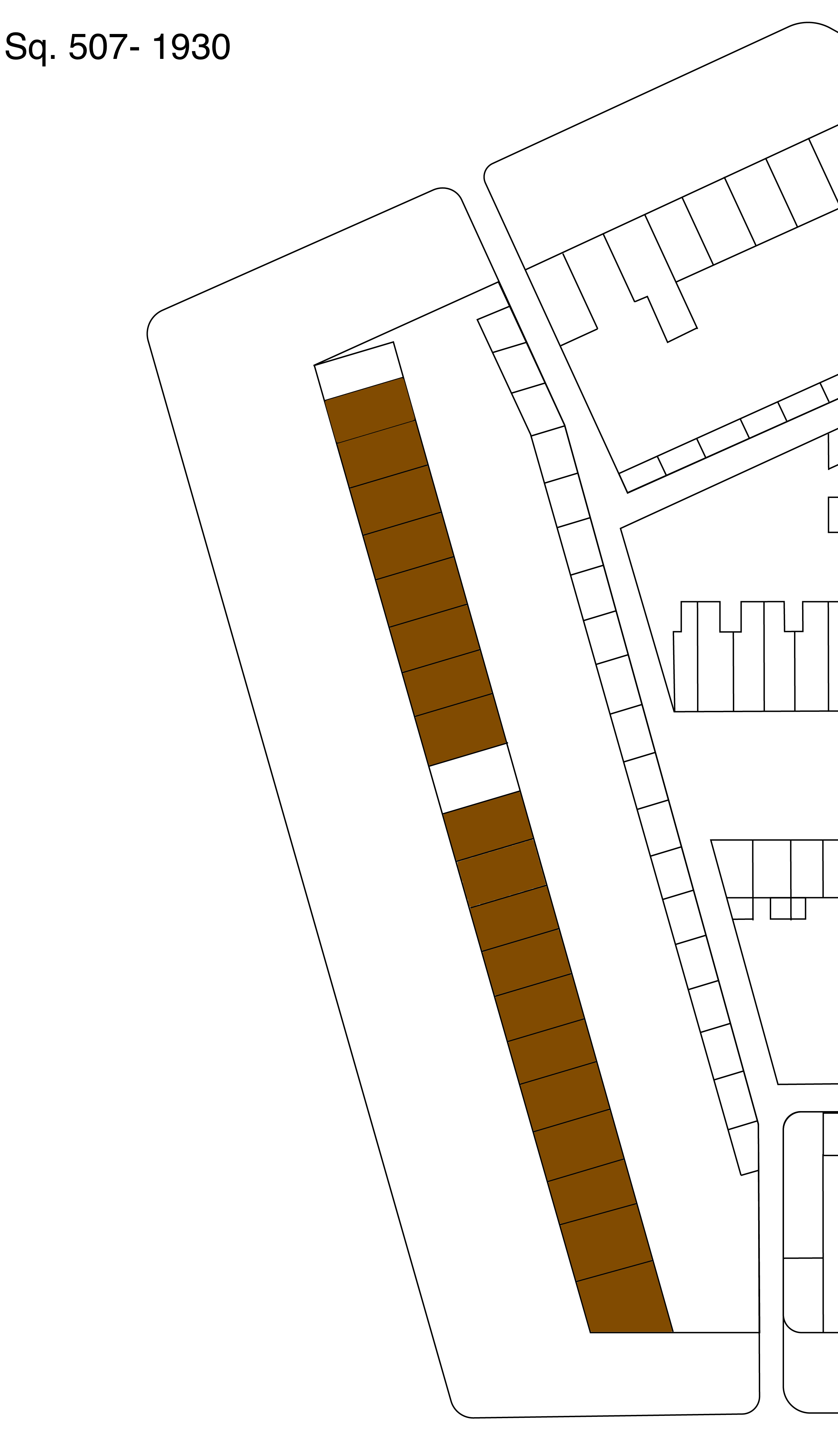
I asked myself the question of why was there a 100% racial change on that stretch of New Jersey Ave from 1920 to 1930 and the Flynns provide a mundane answer. Life went on. Continue reading Change from 1920 to 1930, White to Black, Flynn to Keasley- 1735 NJ Av NW

Sq. 507- What a difference a decade makes 1920 vs 1930

One of the things I noticed with the change in Truxton Circle from 1920 to 1930, was that the neighborhood went from being a racially mixed neighborhood to being a predominately African American neighborhood. One of the places where this change was obvious was on square 507, along the 1700 block of New Jersey Avenue NW.

A stretch of the block that was 100% white in 1920:

1700 blk New Jersey Ave NW, 1920. Orange= White residents; White= No data

…became 100% African American in 1930:

1700 Block NJ Ave NW, 1930. Brown= AfAm residents; White= No data

I wondered why and looked for a reason. The reason may be buried among some of my old posts that I have yet to uncover and repost. I have some gaps between April 2010 and December 2013, and somewhere in there is a post, I swear, about a woman who lived on the block with her sons and I traced them to 1930. By that time Rosalie Flynn (maybe her name, maybe not) had either moved to Virginia or died and one of her sons had moved to the Atlanta area, married and was a lawyer.

So the reason for why one white household left the neighborhood was that people move on.

Many of you are not in the same place you were 10 years ago. A census is every 10 years. People grow up. They get married. Their career takes them to another city or town or even country. Some die. In urban areas, like Washington, DC, people are always moving around.


Scoping a comparison block- Black v White

I have an idea. I would like to compare the land records I have been seeing in my series of Black Home Owners of Truxton Circle with that of white home owners. I would start with the 1930 census because that is when redlining starts. Also the DC Recorder of Deeds online records start around 1921, and I like having a buffer.

The Truxton Circle block will be Square 509E. Why? Because I used to live there. Also It’s not as big as Squares 551, 552, 553, 554, 555, 615, 616, or 617. The small and more manageable blocks are 519, 550, 553W (maybe), 554W, and 618.

So what’s the deal with Square 509E? In the 1940 Census it was 100% Black, had 67 occupied units, and 10% was owner occupied. In the 1950 census, still all Black, 69 units were occupied and the home ownership rate was up to 28%.

The 1950 Census the last and most recent open census, and that is where I’ll stop. Also after 1950 DC experienced white flight, particularly a loss of its white working class and poor. As of this time, the District does not have any white working class neighborhoods.

So I started looking for a 90-100% white comparison block. I was looking for something in Old City. I wanted something with an older housing stock, with row houses/ townhomes. To make it easier on me, no big blocks. I wanted to avoid blocks with large apartment buildings, so that eliminated most of Dupont Circle. Many Logan Circle blocks got kicked out of the running because many blocks did not remain 90%+ white by 1950. I really wanted to keep Shaw blocks finding 90%+ white blocks.

So here are my possible candidates:

Square 980N (Census tract 84, ED 720)- This NE block along Florida Ave in 1950 was 95% white, and 45% owner occupied with only 20 occupied units.

Square 984 (Census tract 81, ED761?)- This block is at E and 11st Sts NE was 90% white, 33% owner occupied with 62 occupied units.

Square 966 (Census tract 81, ED 767)- This Lincoln Park block was 100% white, 23% owner occupied with 40 units.

Square 765 (Census tract 65, ED374)- This Capitol Hill block was 96% white, 32% owner occupied with 54 units.

Square 1255 (Census tract 2, ED564)- This Georgetown block along Wisconsin Ave NW was 98% white, 31% owner occupied with 64 units.

So 980N got eliminated first because I couldn’t find the square on the Library of Congress map site. It seemed to have gotten left off and I need the real estate maps because lot numbers change.

Square 1255 in Georgetown is going to be set aside because the occupations I am seeing appear to be very upper middle class. The Truxton Circle block is more working class and I don’t want to compare it to a block that is more managerial and richer.

Squares 984, 966, and 765 are great contenders because they have several working class residents. There is the odd doctor on the block. Fair enough, 509E had a Dr.

Next, collect the info.

1950 Census

Just a quick comment.

Today the 1950 census drops. I have no plans to do anything. I am going to wait and see who indexes this, and who that indexing is formatted. Then I will update my own database.

What I need to do is update TruxtonCircle.org . If anyone can guide me to who I can talk to (I’ll pay a reasonable fee) about updating the site so I can make it more searchable and dynamic (I know it needs a complete over hall while keeping some of the old links) email me at mari ayt inshaw period com.

Happy Accident-1900 Home Owner- 1603 3rd St NW- William Saunders 1822-1900

I honestly meant to to get resident home owners of sq. 552, for the Washington Sanitary Improvement Company. Because I had incorrect info in my own spreadsheet, which I need to clean up, I wound up researching people who were not on Sq. 552 (3rd, Q, 1st, Bates, and P St) but 551. It also means that the spreadsheet on TruxtonCircle.org is incorrect too.

I discovered my accident when looking at the 1902/1903 General Assessment for Sq. 552 for a William Saunders. I found William’s wife, Martha Saunders over on Sq. 551, (where Mt. Sinai, the NW Co-op and FL Ave Park sit). She had two lots. She owned, 551 009-Background, and 551 00G.

551-LC-1903

Then it dawned on me that the 1600 block was up one block.

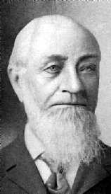
William Saunders was a TC resident, and he has a Wikipedia page (my 3rd TC resident with a wiki) so we have a new blog post.

William Saunders lived at 1603 3rd St NW. According to the 1880 census, he lived there with his wife Martha, and his adult children George W. and Belle. By the 1900 census, it was still him and Martha, and Belle, along with four adult grandchildren with the surname Reeves.

According to his Wikipedia page he “was a botanist, nurseryman, landscape gardener, landscape designer, and horticulturist.” He was the United States’ chief experimental horticulturalist and Continue reading Happy Accident-1900 Home Owner- 1603 3rd St NW- William Saunders 1822-1900

Fact of life- people move

and not just during earthquakes.

People move. If you do genealogy you’ll find that people move around, which is a pain in the butt locating people. The Help comes from a line of lumberjacks, who ran around the northern  US border following trees, and they had a common last name. So it is a guess which state they were in for any given census. My people in NC, though staying in the same two counties, moved around those counties, a lot. So that comes in mind when people say gentrification moves people out of their homes. Life moves people out of their homes. Americans are movers with fantasies that they are stable.

Most people move. A few stay, but in time they move too. In the arguments over gentrification the one family that has been in the same house for 30 years, but easily forgotten are all the other people on the street who stayed for 1 -5 years and moved. Some a few blocks over, some completely out of the neighborhood. Moving people are a bit of a problem for me with the census project as I look at the city directories, which you can find on-line in Google Books: Boyd’s directory of the District of Columbia, 1892 and Boyd’s directory of the District of Columbia, 1903. I can’t speak to the accuracy of these sources as I don’t know how the data was collected, but it’s the best source out there, short of hopping in a time machine. In my own house there were one set of people in 1892, then in the 1900 Census 11 people, then in the 1903 directory one person, all with different names. Considering that many people were renters, there really wasn’t anything tying them to one house, thus freeing them to move.

This page contains a single entry by Mari published on July 16, 2010 8:28 AM.

A real legacy gets past 2 generations

I heard something recently along the lines that it is sad if the only thing you know about your great grandfather is his name. I am a little lucky and not so lucky. I was young when my great grandfather on my dad’s side was alive. I remember him as a brown and skinny man. His name, James, I think. I remember where he lived, and that he lived with great-grandma across the street from my uncle, which was next door to grandma.
My great grandpa Kelly on the other hand, had a farm and the white man took it away. He was also a thin brown man, and his picture is on my downstairs wall. He had a couple of sons, one being my grandfather, the other my late great uncle who moved to DC. He also was an accomplished gardener and aided the family by keeping food on the table (what food could be grown in NC). I know nothing of his wife, she apparently died early as when I found him in the 1910 or 1920 census she was nowhere around.

This page contains a single entry by Mari published on July 15, 2010 10:45 PM.

Mobility and gentrification

I did a phone interview today with someone doing research on gentrification. I think I overwhelmed them with too much historical information or background. The devil is in the detail.
Anyway one of the popular aspects of gentrification to focus on families and individuals being displaced. The problem with that view is that Americans (and maybe other people) are very mobile, so it is hard to say if ‘genrtrification’ could bear the blame, or is the chief reason a person or a family moves. considering people move all the time. I tried to illustrate the mobility of city residents to the interviewer, but didn’t do such a great job.
Here’s one example. in cleaning up some data from the 1900 census I was looking for a Chinese’s fellow’s address. The Census taker must have been drunk because towards the end of the page he was listed a bunch of people with different street addresses (usually there is a block of addresses) and it was barely legible. So I figured I’d fine Mr. Woon(?) in the city directory. In the directory, there were 2 male Woons of the same name in DC neither of them living in the Enumeration District I was researching. He wasn’t the only one. When I couldn’t read the sheet I would refer to the directory which was 2 or so years off from the Census, and it wasn’t helpful because the people tended to live at a completely different address on a different street.
I’ve lived in Shaw going on 10 years, and compared to others that’s not much time, but I’ve seen neighbors come and go for all different reasons. Renters may leave because they graduated college, because it was a health danger, because their landlord was an ass, or because their landlord decided or sell or the bank decided to foreclose. Owners leave because of job re-locations, marriage, divorce, separation, illness, family changes, desire for something different, taxes, frustrations with neighbors, or because the good Lord decided to call them to eternity. In that gentrification plays a part in the owners’ motivation in selling to cash out and maybe taxes. All the other reasons I’ve observed, family breakup, professional moving on and death have very little to do with the neighborhood and more to do with the individuals.

This page contains a single entry by Mari published on June 8, 2010 11:09 PM.

Housing census 1950- Bad bones

This PDF you can find wandering around www.census.gov/prod/www/abs/decennial/index.html
the census website and look at the data and come to your own conclusions. Because
I have a bias, you have a bias, and we filter information differently.

This is for housing, looking at the condition of
houses in the TC part of Shaw, enumeration district 46. ED 46 goes from New
Jersey Ave NW to Florida Ave NW to New York Ave NW. Other parts of Shaw are in
EDs 44, 48, 45, 49, and 50. But I live in ED 46 so that’s what I’m looking at.

In 1950 there were 1766 housing units in Truxton
Circle total. Only 385 of those units were owner occupied, 1,297 rentals, the
rest vacant. What does this mean? If you’re living in the TC the house you’re
in was probably a rental for years because of what I’ve seen in other Census housing
reports. And that means the landlord more than likely didn’t live near the
house and didn’t give the house the same level of attention that a owner
occupied house would get. Of 1720 units, 439 had no bathroom and or was dilapidated,
268 no running water at all and or was considered dilapidated.

Let’s look at a couple of blocks. Census block 2,
Square 507 and Census block 20, Square #617. Block #2 is bordered by NJ, RI, FL
and 4th St. Of 106 units on that block, 26 were owner occupied, 78
rentals, 2 vacant/for sale. Of the occupied units, 47 had no private bath/ dilapidated,
and 7 had no running water/ dilapidated. 100% of the block was non-white, read
African American more than likely. Average rent $37.56 a month. Block #20
bounded by N St, North Cap, O and 1st Streets. Of 189 units, 31 were
owner occupied, 155 rentals, 2 vacant/for sale, and 1 other type of vacant. Of
186 reported occupied units, 90 had no private bath/ dilapidated, 86 had no running
water/dilapidated . 153 were non-white and the average rent was $36.80. To get
a sense, city wide there were 223,675 units, 27,727 with no private bath and 10,965
with no running water, average monthly rent $57.42.

The funny thing is whether a house is considered
dilapidated based on if there was decent plumbing. The actual phrasing is “No
private bath or dilap.”/ “No running water or dilap.” According to the report, “a
dwelling unit is ‘dilapidated’ when it is run down or neglected or is of
inadequate original construction, so that it does not provide adequate shelter
or protection against the elements or it endangers the safety of the occupants.”

In 1960 Block 2 had
77 units, 69 sound, 7 deteriorating, 1 dilapidated. Block 20, 180 units, 45
sound, 86 deteriorating, 49 dilapidated, and a majority of occupied housing
rented. Both majority non-white but not 100% non-white. For both, the number of
units went down, block 2 the most. Renters were the majority still.