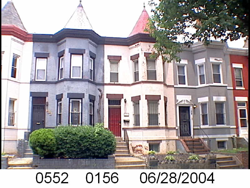
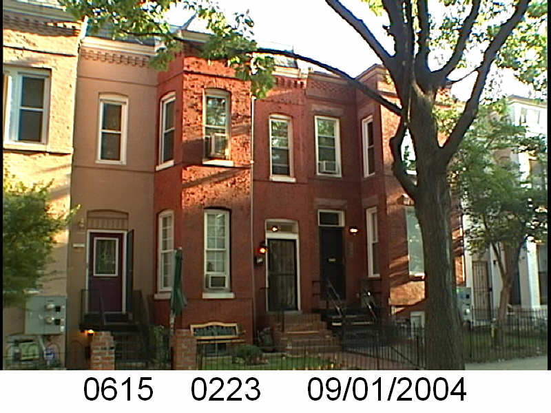
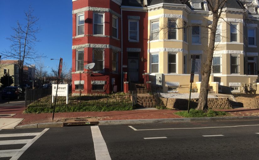
2.5 centuries of DC architecture – In Shaw – Mari in the Citi

Morgan St HousesI have no idea how old these Morgan Street houses are. Mid-Late 19th Century off the top of my head and I think there is some construction going on that block. So this photo is old.
DC has tons of old buildings. Call them historic if you want to get all fancy pants. The folks at RENTCafé sent me this from their post “D.C. Architecture:  260 Years of Home Design Evolution in the Nation’s Capital“. At first glance I thought they did this thing that a lot of people do, include parts of Maryland and Virginia but it looks like it is pure DC (a lot of upper and way west NW, but still DC). So enjoy.

This page contains a single entry by Mari published on May 18, 2016 3:46 PM.

Ten Days of Truxton- The Name- The Hood

Okay, I gotta book that I checked out of the library and I’ma goin’ to use it. The book is Truxtun of the Constellation by Eugene S. Furguson.
I am inspired to write for two reasons one is an article from the WP columnist John Kelly, “There is no Washington, DC– but I’m not renaming my column” and an Examiner article about the TC. In the John Kelly piece, if completely accurate supports my suspicion that people in the last few centuries weren’t sticklers when it came to place names. Federal City, Washington City, same diff. When the most accurate official and legal name isn’t high on your list of priorities sloppiness may occur. The punishment for sloppiness is that long after the responsible generation is dead later generations get to nit pick.
Seriously, someone find me PROOF, actual f*ing primary resourced proof that the Shaw neighborhood was named DIRECTLY after Robert Gould Shaw, and not the Shaw Junior High School, which was. Because prior to the 1950s I can’t find a bit of proof that the neighborhood was even called Shaw, as a neighborhood. Mid City and northwest are the only names that seem to pop up prior to the Shaw School Urban Renewal Project. I am not counting the school districting.
So, ’round the turn of the century there was the Truxton Circle (named for Thomas Truxtun) at Florida and North Capitol. I’ve heard talk that the actual circle was in Eckington. But since streets act as borders, I’m going to say it was bordering West Eckington and Old City. Eckington is a suburb of the City (of Washington).Using the journal Washington History Volume 14, No. 2 as a guide, there is Eckington(1887), Center Eckington (1891) and West Eckington(1891). These sub-divisions are on the other side of Boundary Street/ Florida Avenue and the City residents have just as much claim to the traffic circle as the Eckington and Bloomingdale(1889) ones.
So the Truxton traffic circle was a traffic hazard and it went away. But then appeared a Truxton Post Office. On Florida Avenue, NE, not helping my argument. And then sometime in the 60s or 70s it closed. Then in the 60s came the Shaw School Urban Renewal Area project of which the TC is a part of, but it appears there was no reason to call our part Truxton Circle. Then came the Ward & ANC system in the 70s where Shaw was divided, having most of Shaw in Ward 2 and the TC in Ward 5. In the late 80s when the District government was selling houses and bringing in cable, they referred to the area as Truxton Circle.
Next Ten Days of Truxton: Slavery.

Not a charity but capitalist enterprise

When last I left I was writing about the Washington Sanitary Improvement Company (WSIC) which built the houses along Bates Street NW, and some other streets in the TC that are somewhat Bates adjacent, around the turn of the century. You know they are built by the same company because their 2nd story bay window thing.
Anyway, the WSIC’s goal was to replace the slum dwellings in the various alleys, but as a profitable company and not a charity. From The History and Development of the Housing Movement in the City of Washington, D.C. page 61, Article III, section 4:

The company, although organized from philanthropic motives, is not a charity organization, and the executive committee shall take all legal measures to collect rents and to evict tenants who fail to pay their rent, or who neglect to keep the tenements occupied by them in a cleanly and sanitary condition, or who lead a dissolute or criminal life.

Another thing, as part of the pitch to draw interest in the company the author and secretary of the company George M. Kobr writes:

The attention of capitalists should be drawn to the fact that no class of realty pays as well as alley property in this city, and that there is a splendid field for investment in the erection of sanitary and comfortable alley houses on a business and humanitarian basis.
–page 23

Don't blame me for a fuzzy photo


Bates circa 1907
Originally uploaded by In Shaw

This was taken with an iphone in a lowly lit room at the Library of Congress from a book, while I held the pages down with one hand and took the pictures with the other. Now why are you looking at a fuzzy photo of a bunch of houses? This is the unit block of Bates Street, when the houses were somewhat new in 1907.
The photo, as well as some others I took are from The History and Development of the Housing Movement in the City of Washington, D.C. published by the Washington Sanitary Improvement Company, which built the houses. The book starts off talking about unsanitary crappy housing in DC and how the Washington Sanitary Improvement Company (WSIC) was building alternatives to slummy housing, specifically crappy alley housing. Towards the middle of the book they start talking a bit more about the company as an investment. The directors consisted of the following:
David J. Brewer
Charles C. Cole
John W. Foster
Charles J. Bell
George Truesdell
Gardiner G. Hubbard
Anthony Pollok
Walter Wyman
Henry F. Blount
Mrs. George Westinghouse
Crosby S. Noyes
George H. Harries
William J. Boardman
William C. Woodward
Augustus S. Worthington
Henry Y. Satterlee
George L. Andrews
Bernard T. Janney
Mrs. Clara G. Addison
Willliam C. Whittemore
G. Lloyd Magruder
Joseph C. Breckinridge
Marcus Baker
Katherine Hosmer
Charles E. Foster
Simon Wolf
George M. Sternberg
S. Walter Woodward
George M. Kober
John Joy Edson
Maybe more later. Or not.

A plan for Bates Street

I have the 1968-1974 (the dates I’m unsure of) brochure of “A Plan for Bates Street” in PDF form. It’s a big file and because it is so large, I’m not posting here. However, I will mail it to folks who ask (offer expires in 30 days). Basically, like the title says, it was the government’s plan for the two blocks of Bates, to improve the housing.
Houses on Bates Street (well the houses on Bates I’ve been in) are deep and some of them are divided into two units. It seems that when they were initially built by Washington Sanitary Housing (or Washington Sanitary Improvement, I’m still working on the facts of this), they may have all been two unit structures. You can see it in the placement of windows and doors.
The wonderful fellows at Truxton Circle have a few pictures from the brochure. This first one shows the street plan for squares 552 & 615. It appears there was the intention to remove some structures for the creation of small parks, a tot lot, a teen lot and parking. Spaces for adults apparently were to be carved out of existing space. The second picture, shows a typical Bates Street house prior to any renovation. The first and second floor are two separate units with their own living rooms and kitchens. The plan was to combine the two to make one unit, replace 2nd unit doors with windows, move the kitchen to the 1st floor center, and create more bedrooms, going from 1 to 3 or 4, as seen here.
Looking around Bates Street now, there seem to be fewer 2 unit houses than 1 units.

On this site in 1850, nothing happened

You know I should make better research notes. Or I should leave bibliographic info with the photocopies…. bad librarian. Bad. Anyway, off the top of my head this map is a scanned copy, of photocopy, of a negative copy, of a map that is of the city circa 1850ish. And if I looked hard enough and if it is cataloged by the Library of Congress, I could find the bibliographic info I should have to say who drew the map and so forth. It’s pre-Civil War.
The two light lines are Boundary (Florida) and New York. The squiggly line is a creek. The square numbers are the same square numbers we have today and if you notice…. not a lot of structures. On the negative copy it is easier to see marsh or not-dry-land.
With that in mind I would not even dare call this area, that later became the TC a neighborhood. Heck, I don’t even know if I could call it a community.

Also check out this view of the map.
UPDATE: Better map .

Updated 12/21/23 for bad image links

Square 507 circa 1880 map


This I found at the MLK Library’s Washingtonia Division on microfilm, from the tax rolls, or tax survey, whatever. There was another frame with assessments that said what had a structure on it or if it were brick or a framed structure, but I was too cheap to make a copy. Cheap, or in a hurry or the copy part of the microfilm reader was screwed up. Any of those is possible.