The TruxtonCircle.Org website

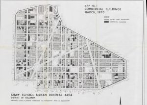
Ran into THE Scott Roberts at one of the last few Sundays left for the 2018 Bloomingdale Farmers Market. He mentioned the Truxton Circle history site. Yes, the date says 2014. I haven’t updated it for various reasons. Here they are:

  1. Data Clean Up: How. I knew there were some problems with the data. Part of the biggest problem was figuring out how to deal with it. I know the best way to eat an elephant is to start with small bites, but the question is how to cook the dang thing. My 1940 data was split into two different tables, because 2 different people worked on it. Because they didn’t transcribe in the same way, that has taken some time to fix. And I wanted to put all censuses into one monster table. I haven’t done that, because the fields change from census to census.
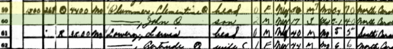
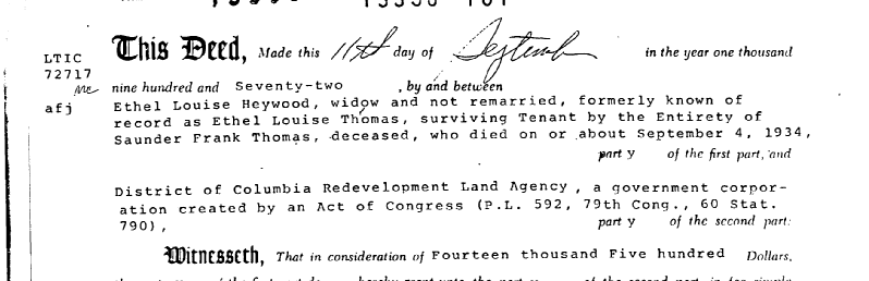
  2. Data Clean Up: Who-What? Another problem with the data is that it contains incorrect and incomplete information. I’ve explored this with my Black Home Owners of 1940 series and the post United States Census- People Lie. I have come to a stop because I don’t know what to do about a man listed as a husband and homeowner when he is neither. When the land records show that his supposed wife is the owner and widow of another man. I’ve stopped before with other challenges, only to restart it when I’ve completely forgotten about them… until I look at my notes….
  3. Data Clean Up: Documenting it all. In my last attempt to clean up the data in the 1940 census, I would document each change in a separate worksheet. So if I found the address was wrong, I would have a line saying on this date which lines and which fields were changed from what to what. It is tedious. My natural habit is not to leave good notes for myself which later winds up biting me in the rear.
  4. Time. I ain’t got it. I got a baby. Destruct-O-baby has eaten up a lot of my time in ways I did not imagine. I thought I knew what I was getting into with adoption, but I didn’t. I am also too cheap to hire a sitter so I can sit down and work on it.  The only reason I’m able to post this is because Destructo is napping.
  5. Wo-Manpower. It’s just me. Back in 2012 I was able to hire two people with the DC Humanities grant. But that was just for a few months. The Help has his own pet project he’s been working on for over a decade. He doesn’t pull me into his project, I don’t pull him into mine. I also did my own website design and maintenance. I am way behind on this, and when I do update TruxtonCircle.org I’ll have to hire a professional to go in and clean it up…… but after I’ve cleaned up the data. Or at least the 20th century data.

Slugg- A book Truxton Circle should read

I was only halfway through the book when I thought, everyone in Truxton Circle, at least those in the Hanover Area, should read. It’s a book those who are buying the Chapman Stables Condos should consider reading, so they can appreciate (maybe) what was there before.

I didn’t suggest Slugg: A boy’s life in the age of incarceration by Truxton resident Tony Lewis Jr. because the last book our book group made was not in audio or e-book format. So I wasn’t at the last gathering, but whoever from our Truxton Circle reading group made a good choice.

It gives a history of the unit block of Hanover Street NW in the southern region of Truxton Circle in the 1980s and 1990s. The whole neighborhood has transformed since those decades and the Hanover area is still transforming. If you think the area is rough, because of S.O.M.E. and other things over there, Mr. Lewis tells his story of the violence witnessed and maybe some of the ‘why’ that violence was there.

It is a very easy read. I read the first chapter quickly and saved the rest of the book for a time when I could sit. I have an energetic 1 year old. I finished the rest of the book in one day and there are a lot of points I’d like to explore more in other blog posts.

Black Home Owners of 1940: Heywood/ Thomas- Updated & Corrected

UPDATE #2- Okay the Haywood/ Heywood confusion was on me and my note taking. So it was Heywood as in Hey! Wood. She also sold the property in 1972 not 1975 as reported earlier. The other confusion is I noticed the date of her husband and it is reflected in the amended post.

I was working on a longer post when I came to a hiccup. People. People are complicated.

So I have a person in the 1940 census named Spencer Heywood, a black man born in Georgia possibly in 1890. He’s a barber. He owns his own shop according to what his wife Ethel Heywood reported to the census. Problem is, I can’t find Spencer Heywood outside of the 1940 DC census. The other problem is the Sanborn map says his house 1649 3rd Street NW does not exist, city directories says it does. If it did exist, it doesn’t exist anymore because there is a Northwest Co-op on that spot.

Sometime the indexing is crazy, maybe his name was misspelled in this or another census. I checked the 1940 census and that area was covered by someone who wrote in clear block letters. Then I checked the property records using that his name. Nada for that time period.

I moved on to the wife, maybe if I can find her, I might be able to locate him. Oh, I found her, but I did not find Spencer anywhere. Ethel appears in the land records for Square 551 (where Mt. Sinai, Florida Park and the Co-op sit) with two names between 1924 and 1972. Ethel Louise Heywood exists in the records between 1950 and 1972, Ethel Louise Thomas is named as the owner of lot H, later lot 0909, between 1924 and 1950. The April 1950 deed links Ethel Heywood and Thomas together naming her as the widow of Sanders Frank Thomas. Another deed from 1944 also calls her the widow of Sanders Thomas. She’s the main owner, but Mr. Thomas is only mentioned again in 1933 and 1937. The earliest record makes no mention of a husband, she acts as a singular entity regarding the business of the property.

So who the hell is Spencer? Could Sanders be Spencer?

In the 1930 census at 1649 3rd St NW, 30 year old nurse Ethel Thomas of Arkansas is living with her husband Sanders Thomas, a 41 year old waiter and DC native, with a lodger Ruth Sweeney, a 40 year old laundress. In 1940 the two residents of 1649 3rd St NW are Ethel Heywood of Arkansas, a maid for the federal government and her husband and head of household, Spencer Thomas Heywood, the barber from Georgia.

According to the 1972 paperwork, Sanders Thomas died in 1934, before the 1940 census, and Ethel did not remarry.

1972 Deed transferring Sq 551 lot 0909 to RLA

I don’t think Spencer and Sanders are the same guy. Okay, who the Hell is Spencer?

My spouse has a crazy theory. He thinks Ethel was upset, leaving Sanders she walked over to a dance club and ran into Spencer Heywood. They hatched a plan to bump off Sanders. Initially, he supposed she went to the Baker’s Dozen on 4th Street to dance her cares away, until I pointed out it didn’t open until 1944, after the 1940 census, and after Thomas’ death. Finally that damned plaque is good for something.


UPDATE- So it’s Heywood in the Census but Haywood in the record.

Black Home Owners of 1940: College Educated Women part 2

Please see Part 1 to read about 2 of the 5 women listed as college educated homeowners in Truxton Circle.

So in this post I’m going to try to find the story behind the remaining women; Miss. Eliza Matthews (60) of 1239 New Jersey Ave NW; Mrs. Blanch Lewis (60) of 1225 New Jersey Ave NW; and Mrs. Lucille Powell (46) of 69 Hanover Place NW.

Ms. Matthews bought 1239 NJ Ave NW in 1922 for what appears to be $9,000. I’ll have to admit, I’m not 100% sure about the various documents I’m looking at, but it looks as if this single black woman was able to get a loan to buy this house at 7% APR. And I can’t tell if she refinanced or got a second mortgage in 1932 from the Washington Loan and Trust Company (Riggs Bank?) for $4,000. In the Census record her name appears to be Elira Matthews, who at the time was living with her ‘sister’, also aged 60, Josephine Butts. Sometime around 1948 Ms. Matthews died and in a will Josephine E. Saunders (nee Thomas) became the owner of the property. Is this Josephine a different Josephine? Curious.


Blanch Lewis, or Blanche I. Lewis was listed as the owner in the 1940 Census, but when looking at other records it doesn’t look as if she really owned the place. In 1937 Edward Wellington Lewis buys 1225 NJ Ave NW from Czech or Serbian couple Ivan and Dorothy Mikalaski. Looking back at other earlier census records for a Blanche Lewis, I found her living in 1910 with her father Edward W. Lewis Sr. and sister Harriet. In 1940 she is still with her 55 year old sister Harriet who was working as a teacher. I’m guessing the Edward W. Lewis who really owned 1225 was a brother, as her father would have been extraordinarily old by 1937. To purchase the property, the loan Edward takes out with the Washington Loan and Trust Company is for $2,500. By 1954 EW Lewis is dead. His siblings William and Harriet E. Lewis are his only surviving relatives mentioned in the land records. It is possible Blanche was a widow and either married another Lewis or changed her surname back, but I think the Lewis sisters were probably spinsters.

Lastly, Mrs. Lucille Powell. I couldn’t find 69 Hanover on a map. I looked at the census page again. The last name isn’t clear, and page seems to be a mix of streets. The last two pages of this enumeration district appears to be a hodgepodge of different addresses. I decided to search for her by name, not location and found a record of a Lucille B. Powell, widow of James C. Powell on Square 617, lot 141 (71 N St NW) from 1944. Looking in a city directory for 1939, a Lucille Powell lived at 69 N Street NW.  Samuel M Powell lived at 71 N Street. Close enough. Regarding the property records, let’s just say it becomes confusing because it appears someone wanted to leave their property to 4+ family members and it just looks like a nightmare to figure out. Those family members include Mary B. Rhambeau (nee Powell), Gladys Powell Reid, Samuel M. Powell, Clara Willis (nee Reid), Miriam Reid Felder, and Lillian B. Branch. I quit. If I wanted to look up the history of a complicated family, I’d do my own.

Black Home Owners of 1940: College Educated Women, part 1

Here’s all 5 of them from the 1940 Census: Mrs. Bertha M. Clark (53) of 35 Q St NW; Mrs. Clementine Plummer (50) of 1500 1st St NW; DC Native Miss. Eliza Matthews (60) of 1239 New Jersey Ave NW; another DC native, Mrs. Blanch Lewis (60) of 1225 New Jersey Ave NW; and Mrs. Lucille Powell (46) of 69 Hanover Place NW. According to the census, these women had 4 or 5 years of college education. Lewis and Plummer were listed as married, and considering my experience with Annie Newsome, I’d have to investigate that to believe it true. Clark and Powell were widows and the only two of the 5, who were listed as employed. Mrs. Clark was a teacher and Mrs. Powell a government clerk.

All of these women were born after the Civil War, so it is fair to assume they were either educated at a Black college or a Northern college that allowed African American students. There is a chance that the two DC natives, Mrs. Lewis and Miss. Matthews attended Howard, or another local college, but not knowing their occupations, I have no idea where to start or look, and with Lewis there is that name change problem with married women.

Starting with Mrs. Bertha Clark, who was married to Ray A. Clark, bought the house together in 1922 for $2,800. The Clarks may have owned other properties in DC, as Mr. Clark was a real Estate businessman, but I’m just going to focus on their life in Truxton Circle, or as known at the time Census tract 46. Ray A. Clark died October 28, 1933, so he shows up in the 1930 census, but is gone by 1940. Like the McKinney’s the Clarks are a dual income (no kids as far as I can tell) household, as Mrs. Clark worked as a teacher. It appears she sells the house in 1947. So like Mrs. McKinney, I should add Mrs. Clark to the list of inquiries for the Charles Sumner School Archive.

Clementine Kay Plummer bought  1500 1st St NW (Sq.554, lot 175) in March 1940 for $2,500. Her marital status is not mentioned, but she is clearly acting as a single entity in the purchase. Her estate sold her house in 1964. Apparently she was declared incompetent by the US District Court for the District of Columbia. Mental Health No. 361-64 if anyone wants to look that up. I’d guess she was suffering from dementia, if you consider her age. These things happen.

Ms. Plummer has a doppleganger, maybe, an African American woman also named Clementine Kay Plummer, also from North Carolina. I cannot tell if these are the same or different women. The Truxton Plummer (age unknown) lived at 130 Thomas Street NW , in Bloomingdale, in 1930 with Marie (20), Owen (14) and John (8) Plummer, as renters from a school nurse named Martella York, who owned that home. When Truxton Plumber is on 1st St, she is just living with her son, John, aged 17, which is just about right. Also in 1930 there is record of a Clementine K. Plummer a 39 year old woman living with her husband Dr. John L. Plummer (49), and children Marie K. (21) an office clerk, Owen Y. (15), and John L.  (7) in Raleigh, NC. That’s….. way too much of a coincidence. The widow of John Owen Plummer Sr., Clementine Kay Plummer of Raleigh, NC died September 3, 1969 in Enfield County, NC of what looks like senility? The cause of death is handwritten on her death certificate, so I can’t really tell. That and the DC court finding Mrs. Plummer incompetent in 1964, makes me think, same person. Her date of birth was 2/21/1885, about five years off the reported age of 1940 Truxton Clementine Kay Plummer.

I mentioned this to my spouse, the Help (aka Weedwackerman) who is also in the history field. It brings into question the accuracy of the US Census and the necessity there is to use more than one source. There is probably more to the story of Clementine Kay Plummer, and should I ever decide to dive into the court records, maybe I’ll look that up.

I’ll explore the lives of the other ladies in a later post.


Black Home Owners of 1940: Dr. Arthur B. McKinney

So I started looking for a woman. But the problem with women is that we sometimes change our last name and lie about our ages. Mrs. Annie Newsome (or Annie Newsone in the 1940 census) was listed as the head of household and married. She appears in the 1930 census with a different possible birthyear. So I gave up on her and decided to look at a professional man who might have more information about him.

Dr. Arthur B. McKinney abducted from Freedmen's HospitalDr. Arthur B. McKinney abducted from Freedmen’s Hospital Sat, May 15, 1926 – Page 2 · The Pittsburgh Courier (Pittsburgh, Pennsylvania) · Newspapers.comSo I chose Dr. Arthur B. McKinney of 1519 1st St NW from the 1940 census. From the little clip above, Dr. McKinney was involved in some odd little caper in 1926 where his brothers abducted him from Freedmen’s Hospital and took him to his mother’s house at 1515 1st St NW. A Della A. McKinney, widow, is listed as a home owner in the 1930 census at that address.

Doing a quick search for Dr. McKinney, he sort of disappears towards the mid 20th Century. I found a 1942 draft card, when he was 52 years old, listing his wife Ethel T. McKinney, who in the census as a secretary. Dual income family! The last record is from a 1948 city directory listing he and his wife at 1519 First Street NW. By the 1954 city directory, Dr. McKinney is gone and only Mrs. Ethel T. McKinney remains, and her job description changed from secretary to Administrative Assistant for the District Board of Education. This is where I would call up the Charles Sumner School Museum and Archives, for more information, but I don’t feel like it.

The newspaper article from the Pittsburgh Courier is, int-ter-rest-ing. Not really sure what the heck that’s all about. I have told many to put me in an Uber if we can avoid sending me to Howard University Hospital, the former Freedmen’s Hospital from which Dr. McKinney was spirited away from by his brothers. So I understand hiring a private eye and concocting some cockamamie scheme to unofficially discharge from the hospital.

Redlining, African American Home ownership and the TC

Distribution of Negro Population by Census, 1930If anyone can find or recreate the Washington DC redline map, that would be helpful, because no one seems to have it. There is a project to map restrictive racial covenants, but those seem to be a small amount of DC housing, rather than the majority. The image here is the distribution of African Americans or Negroes, in DC in 1930, so probably close enough to a redline map.

Considering the map, Truxton Circle or as it was known then, Census tract 46, was more than half AfAm. If it wasn’t a redlined area, it may have been yellow, “Definitely Declining.” The area that became Shaw, ranged from 35% to over 75% black, which may have been too many black people for the Home Owners’ Loan Corporation (HOLC) map makers.

Using data from my TruxtonCircle.org project, I just took a look at the 1930 and 1940 census data*. In 1930, of the heads of households, there were 1109 renters in the TC and 310 home owners. Of those who owned 237 were black. In 1940, there were 1442 renters, 269 home owners, and of those owners, 218 were black. So most people in the TC were renters and African American home owners were a majority of a minority of people.

So who were these Negro home owners? A lot were a variety of government workers (federal and DC schools), service workers (chauffeurs, Pullman workers, waiters) and professionals (doctors, ministers, lawyers) . I’d say the black middle class and prudent working class folks. The same people who’d engage in black flight in the 1970s and 1980s.


*I’m still cleaning up the data.

So Truxton? Shaw? Bloomingdale? Where the hell am I?

Commercial Building Map
Map of Shaw for 1970 Commercial Buildings

So this comes up way too often. So that’s why I decided with this re-boot (messy as it is) that I would call the In Shaw blog Truxton is in Shaw, because it is.

Here is the quick and dirty and maybe in later posts I’ll go deeper.

Bloomingdale is on the other side of Florida Ave, which used to be Boundary Street in the 18th century. Why Boundary Street? Because it was the boundary between the city of Washington and the county of Washington, in the District of Columbia. Bloomingdale, lovely as it is, was/is a suburban neighborhood, in the then county.

Shaw. I have yet, to find ANYTHING, anything calling the area we know as Shaw as “Shaw” prior to the late 1950s, and even then it was called the Shaw School Urban Renewal Area. See the map there? That is of the Shaw School Urban Renewal Area. Everything in it, is Shaw. The area known as U Street, you will see it, in Shaw. The portion known as Logan Circle, you can find it in the map, in Shaw.

Truxton Circle, look at the map, it is IN SHAW.

If it is in this map, it is in Shaw, which kinda stopped being a thing sometime after Home Rule and wards were a thing.

Truxton Circle- People and a lost traffic circle

If you haven’t seen it arleady Left for LeDroit has a post on the Truxton Circle and how you can still find it’s outline today.
And I think I can say I can now start the writing portion of Truxton Circle 1900. I cleaned up a lot of data, deleted addresses that you’d think were in the study area, but aren’t and tracked down people for whom some enumerators were too drunk to write down their addresses. When I started out whites outnumbered black residents by a smidgen. With the data clean-up and address removal, blacks outnumber whites by a smidgen and I still have 4 Chinese guys.
There was this one fellow, Paul Pearson, of 218 N Street. He was a white DC born Druggist, who lived with his Maryland born wife, Emma, and owned his home free and clear. According to the 1899 city directory he worked at 500 New Jersey Avenue NW. The National Association of Realtors building sits where his workplace sat. Considering where his home and work were located he must of had a pretty good commute. And if memory serves me right there was a streetcar nearby that could have taken him straight there.

SQUEEEE!!!! Census data

Ah, the best use of an unemployed college graduate and a spare room. I hired my cousin to do some data entry on the 1900 census and she has just completed enumeration district 64, which is the northern part of the TC. Enumeration District 64 (ED64)goes from the 1400 block (odd #) of NJ to the 1700 block, Florida and Rhode Island Aves, 1st St, to Q and O Streets. I immediately tossed the Excel worksheet into an Access database and created a query about working women. Now I’m still getting used to the updated MS Access program and can’t seem to figure out how to exclude women “at school”. Women over the age of 15, 595 of them had some occupation. Of those 595 women, 473 were black. In 1900 the TC north African American women were laundresses, nurses (child and sick), house servants, and cooks. White working women were saleswomen, teachers, house keepers, landladies, office workers, and seamstresses.

Disclaimer-
To clarify, my census project is sponsored personally by me. I get moral and other minimal support from my employer, as it sort of falls under professional development. Secondly, this is NOT a building or house history project. Things like houses are secondary, people are more interesting. I have no intention of putting the raw data on-line. For one, it’s too much. ED 64 is over 2,500 names alone, and there are 3 other EDs to go. I do hope to go on to census years 1910-1930. However the rate we’re going I’ll probably get through to 1910 or 1920.