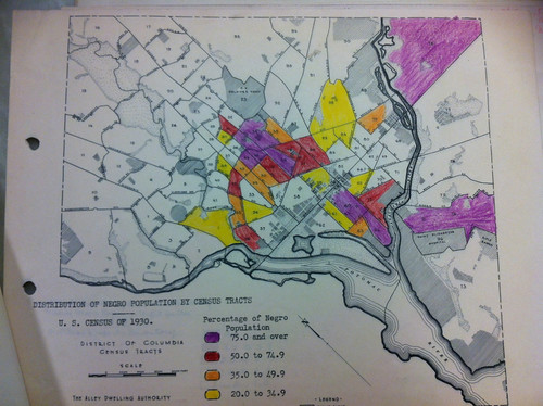
So I started looking for a woman. But the problem with women is that we sometimes change our last name and lie about our ages. Mrs. Annie Newsome (or Annie Newsone in the 1940 census) was listed as the head of household and married. She appears in the 1930 census with a different possible birthyear. So I gave up on her and decided to look at a professional man who might have more information about him.
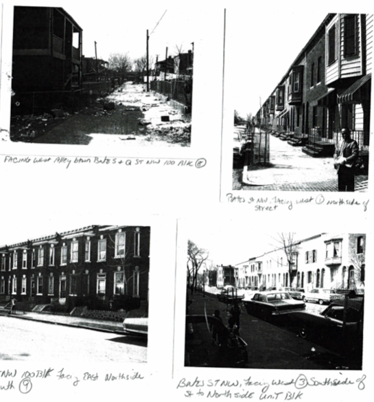
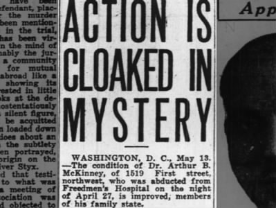 Dr. Arthur B. McKinney abducted from Freedmen’s Hospital Sat, May 15, 1926 – Page 2 · The Pittsburgh Courier (Pittsburgh, Pennsylvania) · Newspapers.comSo I chose Dr. Arthur B. McKinney of 1519 1st St NW from the 1940 census. From the little clip above, Dr. McKinney was involved in some odd little caper in 1926 where his brothers abducted him from Freedmen’s Hospital and took him to his mother’s house at 1515 1st St NW. A Della A. McKinney, widow, is listed as a home owner in the 1930 census at that address.
Doing a quick search for Dr. McKinney, he sort of disappears towards the mid 20th Century. I found a 1942 draft card, when he was 52 years old, listing his wife Ethel T. McKinney, who in the census as a secretary. Dual income family! The last record is from a 1948 city directory listing he and his wife at 1519 First Street NW. By the 1954 city directory, Dr. McKinney is gone and only Mrs. Ethel T. McKinney remains, and her job description changed from secretary to Administrative Assistant for the District Board of Education. This is where I would call up the Charles Sumner School Museum and Archives, for more information, but I don’t feel like it.
The newspaper article from the Pittsburgh Courier is, int-ter-rest-ing. Not really sure what the heck that’s all about. I have told many to put me in an Uber if we can avoid sending me to Howard University Hospital, the former Freedmen’s Hospital from which Dr. McKinney was spirited away from by his brothers. So I understand hiring a private eye and concocting some cockamamie scheme to unofficially discharge from the hospital.