
I don’t want to add too much to this, except to say that neighborhoods like Shaw were in real danger of being destroyed by freeways/ highways. Read the poster and tell me what you think in the comments.
I watched the most recent Jane Jacobs documentary ‘Citizen Jane’, which then led to listening to podcasts about Jane Jacobs and Robert Moses. If you are not familiar with the story, Robert Moses was a very powerful man in the early 20th century who was very good at tearing down structures (slum clearance it was called) to build parks and parkways. However, another word for parkway could be highway. Jane Jacobs was the journalist/ author/ activist who stopped him from building a road or highway through her Greenwich Village neighborhood in the 1960s.
Highways, were the big thing after World War II. Prior to the war cities were big on slum clearance. Slums, according to one definition, were places where there wasn’t a lot of indoor plumbing. But most seem to define it as where poor people live in poor conditions. You mix the slum clearance with the highway funds and you have lots of plans to destroy neighborhoods.
There was a plan to extend I-395 past New York Avenue NW, where it currently terminates. The above map from 1957 shows this. There are a few landmarks to help you figure out where Truxton Circle is in all this, such as the Capitol, Union Station, Logan Circle and Mt. Vernon Square. Where you see the #10 is a white mass of something, that is a proposed expressway that was to connect I-395 to an inner loop. To create this roadway tons of housing in what is now Truxton Circle would have to be destroyed. Actually, if this were to have gone through there would not have been a Truxton Circle neighborhood.
So what happened to keep this from happening? The sixties. There was a change in the 1960s where people pushed back against the government, and this was a government plan. The culture of the Civil Rights movement played a major part in this, and that is another post for another time.
So I was bopping around the Library of Congress site, looking to tell one story. Well, because I’m too lazy to figure out how to search properly (I’m very disappointed in myself as a librarian) I came across a few photos of life in 1942 around the area of 7th and Florida Avenue NW. As you know Florida Avenue tends to make up the northern border of Shaw, or what was to become Shaw. This prior to the urban renews plans and prior to Shaw being named Shaw as a neighborhood.
Anyway….
These photos were taken by the noted African American photographer Gordon Parks. He like other notable photographers like Dorothea Lange, worked for the Farm Security Administration. As you can see and as you know, this area is not a farm, little matter…. old timey pictures, yay!
If you look in the reflection of the window with the hats, I believe you can see the building that houses Halfsmoke, maybe. I know there was a football stadium over there where Howard University Hospital sits, and those are the stadium lights you can see in the reflection as well. However the turret is not exactly the same so, I’m not sure.
From these photographs I can see hanging out on the 1900 block of 7th Street is a historic activity. However the panhandlers of the 1940s were a heck of a lot better dressed than the hangers out and the odd panhandler found between Florida Avenue and S Street these days. They wore hats in the 40s. And they sold hats on 7th Street. At this moment I don’t think you can get a decent hat on 7th, unless you have one delivered to the Amazon pickup locker at the 7-11 on 7th and Rhode Island.
At some point I’ll actually get around to posting the things I meant to post. Until then, enjoy.
Over a decade ago when I was looking for a place to buy a home that was affordable and close to enough stuff to maintain my car-less lifestyle, I was doing some serious research on Shaw. In December of 2000 the Washington Post had a series called “Fatal Flaws: The District’s Homicide Crisis” and along with it was a map showing a big gigantic splotch of unsolved murders along Rhode Island and Florida Avenues. And when I moved to the neighborhood, I would hear gunfire almost nightly. Sad, and eventually ugly, memorials of rain sodden stuffed animals and empty liquor bottles littering the sidewalk were a common sight. The crack years were winding down and people were still getting killed over turf battles.
So with all these people dying violent deaths in the streets and parks of Shaw & nearby Sursum Corda, the area should be littered with spirits of the dead if you go by ghost rules. The Help and I, enjoy a good ghost story of the mild horror genre. The usual story is such and such a place is haunted because X number of years ago so-in-so died a tragic and violent death. By this logic 7th and O should be paved with the poltergeists.
We have friends who had to shoo people away from the Seminary up in Forest Glen when it was vacant and before it went condo. It was said to be haunted. People love haunted large buildings. People also like “interesting” haunting by interesting, middle class or wealthy persons or people associated with the wealthy. Haunted castles, yes. Haunted public housing, not so much.
I do relate to the supernatural, but in the regular practice of my religion. I am a skeptic regarding ghosts. That scratching in the walls? Rats. Maybe, squirrels. Lights flickering? Possibly crappy wiring by a crappy contractor or blame Pepco. Ghostly figures walking across the room? Obviously, your eyes are engaging in time travel.
I’m all about time travel.
This PDF you can find wandering around www.census.gov/prod/www/abs/decennial/index.html
the census website and look at the data and come to your own conclusions. Because
I have a bias, you have a bias, and we filter information differently.
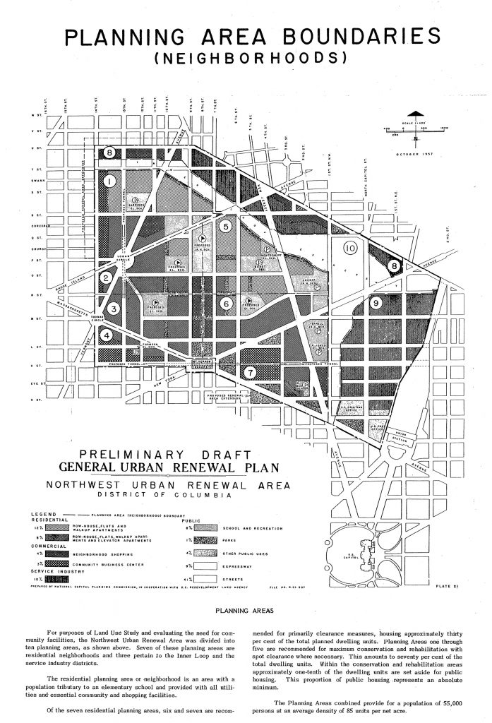
This is for housing, looking at the condition of
houses in the TC part of Shaw, enumeration district 46. ED 46 goes from New
Jersey Ave NW to Florida Ave NW to New York Ave NW. Other parts of Shaw are in
EDs 44, 48, 45, 49, and 50. But I live in ED 46 so that’s what I’m looking at.
In 1950 there were 1766 housing units in Truxton
Circle total. Only 385 of those units were owner occupied, 1,297 rentals, the
rest vacant. What does this mean? If you’re living in the TC the house you’re
in was probably a rental for years because of what I’ve seen in other Census housing
reports. And that means the landlord more than likely didn’t live near the
house and didn’t give the house the same level of attention that a owner
occupied house would get. Of 1720 units, 439 had no bathroom and or was dilapidated,
268 no running water at all and or was considered dilapidated.
Let’s look at a couple of blocks. Census block 2,
Square 507 and Census block 20, Square #617. Block #2 is bordered by NJ, RI, FL
and 4th St. Of 106 units on that block, 26 were owner occupied, 78
rentals, 2 vacant/for sale. Of the occupied units, 47 had no private bath/ dilapidated,
and 7 had no running water/ dilapidated. 100% of the block was non-white, read
African American more than likely. Average rent $37.56 a month. Block #20
bounded by N St, North Cap, O and 1st Streets. Of 189 units, 31 were
owner occupied, 155 rentals, 2 vacant/for sale, and 1 other type of vacant. Of
186 reported occupied units, 90 had no private bath/ dilapidated, 86 had no running
water/dilapidated . 153 were non-white and the average rent was $36.80. To get
a sense, city wide there were 223,675 units, 27,727 with no private bath and 10,965
with no running water, average monthly rent $57.42.
The funny thing is whether a house is considered
dilapidated based on if there was decent plumbing. The actual phrasing is “No
private bath or dilap.”/ “No running water or dilap.” According to the report, “a
dwelling unit is ‘dilapidated’ when it is run down or neglected or is of
inadequate original construction, so that it does not provide adequate shelter
or protection against the elements or it endangers the safety of the occupants.”
In 1960 Block 2 had
77 units, 69 sound, 7 deteriorating, 1 dilapidated. Block 20, 180 units, 45
sound, 86 deteriorating, 49 dilapidated, and a majority of occupied housing
rented. Both majority non-white but not 100% non-white. For both, the number of
units went down, block 2 the most. Renters were the majority still.
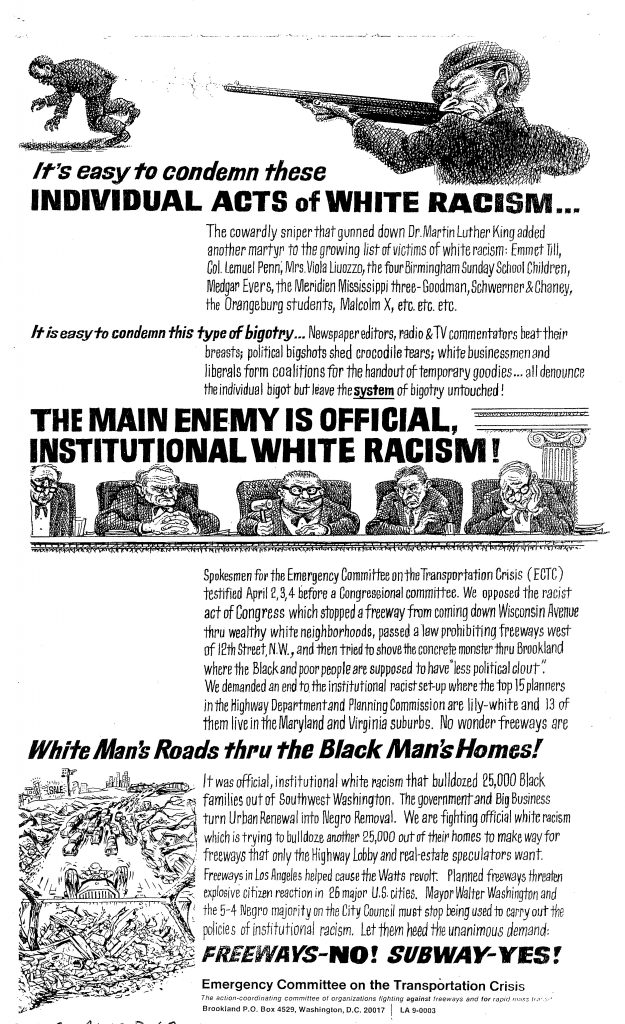
As far as I can tell this church no longer exists. Well in Washington DC. Not anymore.
The reason why I’m typing this up is because someone. I can’t say who. Annoyingly has a lot of personal chaff included in federal records. Some of that chaff, provides glimpses of a life partially lived at Rhode Island and North Capitol streets. The person in question was white, college educated, married and is currently very dead. He was the head, for a number of years of a Federal agency. He resided in various parts of Alexandria during the 40s and 50s. And he went to church in Edgewood? Eckington?
His church home was the Evangelical Lutheran Church of the Atonement. I can tell because of other chaff and detritus left behind, such as church programs, pledge statement, and Lutheran publications.
What does this stuff, which personally we should really throw out our own light and gas bills at least 5 years after they’ve been paid, tell me about a ELCotA parishioner? Apparently you didn’t have to live near the church. You could just drive in from Alexandria, worship in DC and I guess go to the office. Because seriously, how does this stuff wind up in your working files?
Anyway, commuting church goers aren’t new and we still deal with them to this day. I just hope none are not the head of a government agency and have a habit of stuffing church crap in their office files.
Center City Charter School is going to be closed. It’s the school looking at the rear end of the Convention Center. I wouldn’t be surprised if some nearby businesses decide it’s better to be closed than pretend that the attendees of this shin-dig are going to make up for your regulars who decide the hassle isn’t worth it. Call ahead to any location in the lockdown zone before heading out, but then again that might be more than what you might want to do.
I am taking Monday off to observe the impact of this on the hood. I’m not going to protest as was suggested. The last time I stood on a corner with a sign was 1988. And after observing too many lame lunchtime protests (a noontime protest lasting long enough to document) from my work window, I personally don’t care for that mode of petitioning one’s government regarding grievances. I’m more of the letter writing, calling and blogging type as those modes have been more fruitful and satisfying. Also I’ve been informed that there have been threats and since I find no great romance in getting arrested or mistaken for a threat (can never be too careful, that woman with the cardboard sign could be hiding something!), I’m going to try not to bring any attention to myself as I observe and document.
I noticed as I documented the fencing that’s already in place, some residents were blasting some horrid gangsta rap from the windows. That’s one form of protest. May I suggest a little Jay-Z. Torture them with the inability to publicly sing along.
So I have sworn I’ve seen this storefront church window before, I just can’t remember where. Driving me nuts now.
Anyway, where did I leave off? 1957. Italians.
Next is your favorite and mine, Shiloh Baptist church at 9th & P, then led by Rev. Earl L. Harrison who lived at 1743 Webster St NW, which I believe is in the Crestwood neighborhood. It had a membership of 7200 people, 1,200-1,500 attending worship services any given Sunday, with 3% living in the urban renewal area and 95% elsewhere in DC. There are no stats regarding occupational makeup. In 1957 they had a scouting program made up of participants from the church and the surrounding community, and a Baptist Training Union. It was founded in 1863 at 17th and L Streets and moved to its current location in 1924.
Bible Way Church of Out Lord Jesus Christ is not in Shaw but I find it very interesting. It is one the other side of NY Ave at 1130 New Jersey Ave NW. Their pastor, Rev. Smallwood E. Williams lived at 1328 Montello Ave NE. They had a total membership of 2000 people, and the average attendance exceeded the membership with 2200 (3,200 for all three services), it seems they had a lot of visitors and I gather a lot of non-tithers. Thirty percent lived in the renewal area and 69% scattered throughout the rest of rest of DC. This was a working class church, and that’s why I find it so interesting as 90% of the working people attending were ‘unskilled manual’, with 2% professional, 3% white collar, and another 3% skilled manual labor. They had no mortgage and seemed to have owned a good chunk of land down there.
Last in my review is a church that was a storefront that is now a steeple church and that is Mt. Sinai Baptist Church at 1615 3rd St NW, then led then by Rev. Charles Hayes of 47 M St. NW. It had a membership of 225 people with an average worship service attendance of 125. A insignificant number of members, two percent, lived in the renewal area, 96% were in the rest of DC. Occupationally it was 55% unskilled manual, 40% white collar, and 2% professional. They had a mortgage of $2K. Listed under “Future Expansion Program” they desired to build a new church on the present site. If it became necessary to move (because of the renewal) they wanted to stay in this central area so it would be accessible to all members.
SUMMARY
Shaw had a lot of churches then, has a lot of churches now. There were Italians running around the TC on Sunday. And Marie doesn’t like to spend a lot of time typing.