Back in the aughts, I was looking for an Episcopal Church (St. A &A) but I had the address all wrong. I knew it was somewhere near or along Massachusetts Avenue but I was lost. I was running out of time, and so I saw Luther Place and thought ‘Episcopal/ Lutheran…. close enough’, and joined them for service.
Looking at the 1957 Church Survey for Luther Place, the congregational makeup is fairly similar to the small crowd of people I encountered when I wandered in sometime between 2000-08, mostly white. It was a very small group and it was so long ago. The 1957 crowd mostly (67%) lived in other parts of the city and good quarter living in the ‘burbs. I’m sensing a trend of 1957 Shaw churches being commuter churches.
I went to St. Luke’s once or twice when I was church shopping. Although it doesn’t say so on the 1957 Church Survey for the Northwest Urban Renewal area, the ethnic makeup was primarily African American. Maybe it was a little more mixed in 1957, but circa 2001-2002, for the visit(s) I made, it was an African American congregation.
Regarding the number of parishioners who lived in the urban renewal area, the survey says that a number used to live in the area but in a period of 10-15 years many began moving out. Actually, they don’t give any numbers. How many people lived in the urban renewal area….. “a few.” How many in the rest of DC? A “large majority.” How many out in the burbs? Well, there we get something numerical, “few (8 families).” They had parking for 44 cars, so let’s call it a commuter church.
Let’s also call it a retiree church. Though professionals (17%) and white collar workers (29%) had significant numbers, I couldn’t help but notice the 22% of the congregants being retirees. So far it doesn’t look like the other churches I’ve featured had so many retirees.
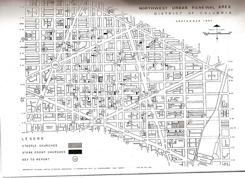
Okay, let’s do a Shaw Church for this series of churches in the 1957 Church Survey. A survey that has never been done since, because a later “survey” done in the 1970s or 80s was very uninformative compared to this one. My last church was Metropolitan AME, and before that Eckington Presbyterian, so I figured I bring the posts back to the part of the Northwest Urban Renewal Area that later became Shaw.
Mt. Gilead still stands at 1625 13th St NW. According to their history website, their church building was bought at auction from Trinity Baptist Church in 1932. The church (people) itself was a mission group of about 75 people who started this church. As far as I can tell from their site, it is still an African American church.
As you can probably see from the document, there isn’t much of a description there. It has publically available information about the building, and isn’t as informative as the previous excerpts.
So I’m going to go into the well that is the October 1957 Northwest Urban Renewal Area Church Survey to look at churches that may or may not still exist in Shaw.
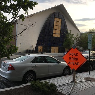
Lincoln Memorial Congregational is one of those churches that fit into the may and may not exist limbo because the church is no longer functioning and held its last service in 2018. In the September 30, 2018 Washington Post article regarding the church’s shuttering, about a dozen parishioners would show up on any given Sunday. The stated reason for the reduced numbers was the demographic changes in the neighborhood and problems with parking. When you look at what was going on with the church in 1957, neighborhood demographics didn’t matter as much as the parking.
The Northwest Urban Renewal Area was bigger than the boundaries of Shaw, and encompassed most of Shaw, and only a quarter of the 725 members lived in the urban renewal area. According to the 1957 survey, a majority lived in other parts of DC. A notation says those congregants outside of the urban renewal area lived in upper Northwest, Kenilworth and Brookland. Half of the working parishioners were white collar workers, I’ll guess members of the Black middle class who probably had cars and drove/ car-pooled to church. Those other parts of DC are too far to walk to church in one’s Sunday best.
So I’m trying something new here. Putting the PDFs on Scribd, so I can share this. So let’s go over the church’s info shall we?
It reported having 175 members with 85 showing up for regular worship service. For those of you unfamiliar with church attendance, not everyone shows up every week. You’ve got once a week, once a month, and once everyso often members. Depending on the church, some people can remain on membership rolls long after they’ve moved to another church or stopped attending all together. Also some people attend and don’t become members. So there is that.
There is another section about membership, that’s the juicy part, if the info is there. It is a black church. That’s sort of in the name, AME, African Methodist Episcopal church, but they identify as “negro” church. Unfortunately, they don’t describe the geographic disbursement of the membership, so I don’t know if this is a neighborhood or commuter church. However, later in the report, at the end, they mention the location is central to it’s membership, which hints that it may be more of a local commuter church. I add ‘local’ as in not in the neighborhood, but having people commute by foot or bus from nearby neighborhoods. This is the 50s, people would send their kids to walk to school miles away, in the snow, uphill, both ways. The occupational distribution is also interesting, as the church reports membership being 50% white collar and 40% unskilled labor.
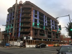
Looking at the 1957 Northwest Church Survey, Scripture Cathedral did not exist. It would have been at 9th and O Streets Northwest. But the only thing on that block was a storefront church called Christ’s United Baptist Church at 1329 9th St NW, now an outreach center. So historically, in my opinion, this means it can’t claim a rich history with the neighborhood. And I don’t feel like researching it to see if this was a post riot church. Looking at the website for Scripture Cathedral, currently in PG County, they don’t provide a useful history, or details.
The website for the condo building replacing it has plenty of details about the condos, ranging from $600K to $2 million.
The usual narrative would be Black church replaced by rich (let’s just assume) white condo owners, and then we are supposed to feel bad about losing people who park poorly in the neighborhood. Instead let’s go with ‘yay, new neighbors who may be overpaying for their home.’ Seriously, people still get shot a block or so away on 7th Street, and they can come home from the Mt. Vernon metro assaulted by the smell of K2 in the air.
Looking at the whole volume of the October 1957 Northwest Church Survey, there are plenty of churches that no longer exist. Churches that may have left because they ended their normal church lifecycle. Churches that picked up and moved before and after the riots, and before and after ‘gentrification.’ Neighborhoods change.
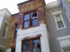
When I read studies about housing, housing stock and affordable housing, as it applies to areas like Shaw, I can’t help feeling there is a very wrong assumption flowing through them all. I encountered, that feeling when talking to a renter on my street who would love to buy, but was unaware of what some of us did to make affordable homes livable, and once they became livable, unaffordable to people like him. A house that was affordable in Shaw in the 80s or 90s is probably not the same house that stands today.
In the 1940s-50s Shaw was described as a slum. A slum was defined in some writings as an area where a significant number of houses lacked indoor plumbing or interior toilets, thus slummy Shaw. I want you, dear reader, to think about that. Living somewhere, when you have to go, you’ve got to go….. outside. But now there are laws and regulations so when you rent a place, you get that fancy pants indoor bathroom with hot water.
But there are other housing deficiencies that houses in the 90s and early 00s suffered from because of the history of disinvestment in the neighborhood. Disinvestment meaning, landlords and homeowners had no incentive to maintain properties, beyond necessity, with little to no equity gained. Not updating kitchens, or electrical wiring, or plumbing, resulting in cramped little kitchens, wiring that would fry your electronics, and leaky pipes.
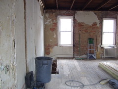
House under renovation.
Then came the renovations and the gentrification. Some were crappy and cosmetic, like my house when I bought it, and some actually fixed long neglected problems or updated systems. Even crappy renovations cost money and those costs are pushed onto the end user, the home buyer or the renter. Yes, there are places where there has been no, to little reinvestment, and the prices act as if there were.
So next time you read a report that assumes the equity gained due to gentrification is unearned, question if the house that was affordable in year X is of the same quality, with the same features, when it is unaffordable in year Y.
A copy of the National Capital Planning Commission’s October 1957 Church Survey that I copied part of is sitting on DDot’s website. But it is a partial copy of the whole report. One of my bad habits, not citing where I got the document, has bitten me in the butt, and I never got around to copying the whole thing. Until now.
Thanks to interlibrary loans, I have been able to get my hands on a copy from a college library several states away. I don’t know why I couldn’t find a copy of this book locally.
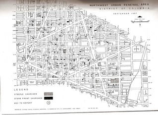
The Church Survey has data on 108 63 churches that were in the Northwest Urban Renewal Area. The powers that be decided to shrink the urban renewal area down, and out of it, we get the Shaw School Urban Renewal Area, that became known simply as Shaw.
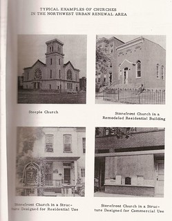
The survey looked at all kinds of religious houses, from steeple churches, storefront churches to house churches. There are several churches mentioned in the 1957 survey that no longer exist. I notice this as I copy each page. A lot can happen in 62 years. There are others where the church changed hands or names. The quality of the surveys vary from church to church. Some entries give great demographic information about the church, parishioners, staff, and programing. Most entries give the address of the pastor, size of membership, a short list of types of programs, and publicly available information. The sparse entries are just publicly available land information and maybe whatever could be observed from the outside.
So far my plan is to copy the whole book, splice in what I previously copied and, since it was a government document, put it on-line.
So I was rooting around in my electronic files and found this. I’m still pecking away at the Black Home Owners of 1940 in Truxton Circle, but 9th Street NW is more Logan Circle, than our triangular section of Shaw. So, no surprise. Carter G. Woodson, noted African American historian was a home owner, tax payer on Square 365.
That’s all. Visit his house if you’re bored. Make the National Park Service’s investment in the place worth it. They are open Sunday, Thursday and Saturday.
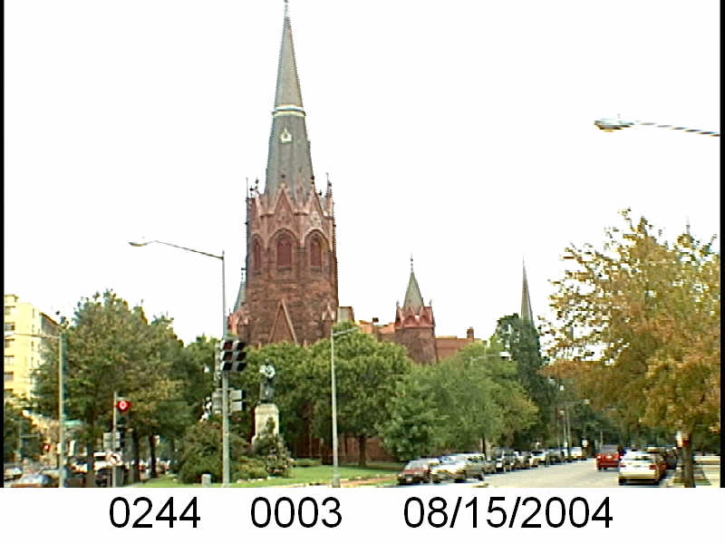
There are dozens of churches that existed in general Shaw area in the 1950s that are no longer around. Some church congregations moved, some churches are closed by their denomination, there are a variety of reasons. The Lincoln Memorial Congregational Temple at 11th and R St NW, 2-3 blocks from the Shaw metro R Street exit had its last service this weekend.
The Washington Post made mention of gentrification in its article about the church’s last days. There isn’t a direct blaming of gentrification, but there is a lot of hinting. The church attempted to reach out to neighbors, added some programing but couldn’t get the membership numbers up after the Rev. Benjamin E. Lewis retired. Yes, parking pressures didn’t help. But looking back at the 1957 Church Survey (PDF), Lincoln UCC church members mostly lived outside of the Shaw neighborhood.
The Church Survey from October 1957 looked at steeple, storefront and residential houses of worship from a block over from U St, Florida Ave, 14th St NW, Mass Ave and 2nd St NE. Lincoln UCC was one and in 1957, 74% of parishioners lived outside of the map in Brookland and Kenilworth. Those 25% who did live in the Northwest Urban Renewal Area were reported to be elderly members, who should be more than dead right now. Don’t blame the demographic changes on the church’s decline.
When doing neighborhood history, I encounter many quaint fictions. Most of them are harmless. There is the belief that residents are home owners. And there’s the idea that church congregants lived in walking distance. Some do, many don’t. Bible Way Church, which stopped the I-395 from destroying Shaw and going all the way through, only had 30% of its members in the Urban Renewal area. Mt. Sinai who will host tonight’s BACA meeting, had 96% of its members scattered elsewhere in the city. The upper and middle class Blacks who supported and were a part of these churches did not all live in the slum that was Shaw.