
Don’t say the unemployed have nothing to do. My cousin whom I have tasked to give me census data in exchange for room, board, and a mictroscopic stipend is getting pressure from her unpaid internship and parents to do other stuff. But regardless I got more data, this time enumeration district 104 which covers North Capitol, parts of 1st, the alley behind 1st (so distictive it doesn’t even get a real name) unit blocks of Hanover, Bates, Q, O, and P. Here is just a taste of what I got:
46 Bates St Kraft, Annie Head White Female (born)Jul 1861 38yo Widowed (born)Maryland Ireland(parent) Ireland(parent) ???(occupation) Rented
She lived with her twin daughters aged 18, Emily & Katryn, who were hairdressers, 16 yr old daughter Mabel a saleswoman, 15 year old son Albert, a salesman for a grocery store, and 14 year old daughter Ida who was still in school. They shared 46 Bates with another family consisting of 4 people.
I still have yet to do quality control for ED 64, but it looks like I might be done with 1900 by mid January.
Tag: neighborhood history
The past is a weird country you only get to visit via travelogues
I was chatting with my cousin about the census project. We were on the topic of occupations. Some bewilder her, like hustler and huckster and compositor. Then there are others where she was amazed at the sheer number of laundresses. Lota lota laundresses. Off the top of my head I was trying to remember the history of Washington DC domestic service, along with the history of American consumer culture and the rise of the home washing machine and indoor plumbing, which would have made a laundress unnecessary. Later, conditions changed where the “need” & “supply” for domestic servants (another large female occupation) disappeared.
She also noted the large number of people in one house, also unusual for our time, normal for then. I explained that several houses in the neighborhood were two or more units. You can see it with some of the Bates Street houses still, where there are two doors, one for the lower unit, and another for the 2nd floor unit. Regardless, there would be three generations sharing a house or a unit.
Another shocking thing I told her, not revealed in the data, but coming from the whole laundress and plumber (a biggy for white males) discussion, was the lack of running water in many neighborhood houses. Yes, not every house had running water inside. Think of all the things you use that requiring water on command (toilets, dishwasher, shower, etc) and imagine not having that. I illustrate this for her I recalled one of our late grandmother’s odd habits such as keeping a chamber pot under her bed. She had running water, but she was, eh, mentally ru-ral. The running water problem lasted up till about the late 50s or 60s in parts of Shaw.
Renting and owning in the upper TC 1900 style
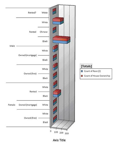
This is the one chart I’ve managed how to figure out to do. I could go through the training course to figure out Access 2007, but right now I’m going to fool around with it and hope for the best. So in fooling around with the data I present the above. It is the level of ownership and renting for blacks, whites and one Chinese guy, divided by gender. Just going by heads of households, blacks outnumbered whites in the northern (1st, O St, NJ, FL & RI Aves) portion of the Truxton Circle study area, and most households rented. There were two types of ownership shown here, mortgage and free. Free, meaning free and clear, meaning no mortgage and the heads owned the house outright.
Now given that most housing is rental housing it would stand to take it that people where a bit mobile, as renting a house doesn’t tie one to a place for any longer than the lease. It will be interesting to see if I can get to the 1910 census how many people remained in the same spot for 10 years or more. I’m gonna bet very few, less than 5-10%. Looking through I know that at some point there is a large influx of North Carolina and South Carolina Afro-Americans who show up in later censuses, so far I see a lot of District natives, and people from Maryland and Virginia. And just as a note, so far no Italian borns, I’m guessing all those Italians who were around to support the Catania were living in an enumeration district we haven’t gotten to, or had not arrived. Well when I get the eastern TC data I’ll play with that too.
SQUEEEE!!!! Census data
Ah, the best use of an unemployed college graduate and a spare room. I hired my cousin to do some data entry on the 1900 census and she has just completed enumeration district 64, which is the northern part of the TC. Enumeration District 64 (ED64)goes from the 1400 block (odd #) of NJ to the 1700 block, Florida and Rhode Island Aves, 1st St, to Q and O Streets. I immediately tossed the Excel worksheet into an Access database and created a query about working women. Now I’m still getting used to the updated MS Access program and can’t seem to figure out how to exclude women “at school”. Women over the age of 15, 595 of them had some occupation. Of those 595 women, 473 were black. In 1900 the TC north African American women were laundresses, nurses (child and sick), house servants, and cooks. White working women were saleswomen, teachers, house keepers, landladies, office workers, and seamstresses.
Disclaimer-
To clarify, my census project is sponsored personally by me. I get moral and other minimal support from my employer, as it sort of falls under professional development. Secondly, this is NOT a building or house history project. Things like houses are secondary, people are more interesting. I have no intention of putting the raw data on-line. For one, it’s too much. ED 64 is over 2,500 names alone, and there are 3 other EDs to go. I do hope to go on to census years 1910-1930. However the rate we’re going I’ll probably get through to 1910 or 1920.
Anyone wanna take bets on the WD/Shaw Library Windows?
If you walk or ride by the corner of Rhode Island and 7th you’ll see the skeleton of the Waltha Daniels Library going up. When it is all done it will be all modern looking with glass sides. But here’s the thing, we’ve had an unfortunate spate of shootings near the Shaw/ Howard University metro entrance, including one incident yesterday. Worse yet those last few shootings occurred around rush hour. What is this? Are the shooters getting off work or school thinking, “3:30 leave. 4:00 shoot at Quay-Quay. 4:05 run over to the 7-11 and pick up a Coke and some Ding Dongs.” So you mix people with questionable aim, guns and a glass library. I’m sure the library designers are putting in bullet-proof/ shatter-proof glass, but even still.
Guess the problems that used to be at Kelsey Gardens have mosied on down to Lincoln-Westmoreland. Lincoln-Westmoreland had problems on its own before, but was just one of several problem spots up and down 7th Street.
Lincoln-Westmoreland was one of those church sponsored housing buildings that went up in the early 70s. It is named for the two churches involved, the Westmoreland Congregational Church (white) and the Lincoln Memorial Congregational Temple (black), both could be described as being predominately middle class. Apparently these were built to fight poverty. Though it concentrates poverty (a popular thing to do back then) it does provide housing. I should say the Feds chipped in money into the building and was completed in 1971.
Schools and Rec 1968
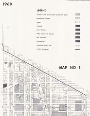
Okay, not as exciting as the segregation map, but this is of the neighborhood. The actual map is bigger but there is only so much that will fit on a photocopy machine or scanner, so deal. This is a National Capital Planning Commission map from 1968. Please take care to look at where Bundy is. That shading that is on its western and northern sides is recreational land. The land the school building sits on is school land.
I also uploaded some maps of the elementary, ,junior high, and senior high school borders in Shaw in 1968 on to Flickr. Just look in my DC maps set.
1236 New Jersey Ave NW, late 19th century
I found something today and I’m all excited. There was a Navy file where the applicant threw in his home address, though it wasn’t required….
Albert W. Evans lived at 1236 New Jersey Avenue in 1898 with his wife and child, applied to become a Hospital Apprentice First Class in late 1898 at the age of 26. He was born in Alexandria, VA. Wore glasses (according to other paperwork in his file) and had not so great vision even with them. Of his education he wrote that he went to, “the public High School, and was graduated in Medicine in 1894, from the National Medical College [in] this city.”
He was applying to the position because he wrote that the money he was getting in his then current wasn’t enough to support a family.
38-P9-Bx1
From the Pile: Bundy School & Park
The pile knows all, and the pile is very, very disorganized and headed for the recycle bin. I find stuff of interest and it goes into the pile.
Here’s something from the pile, a 1968 report on public facilities. The most interesting stuff is about DC medical clinics in Shaw that are no more. Not counted are non-DC government clinic such as Children’s Hospital (still over in northern Shaw). Anyway amongst that stuff is a listing of DC government land and US Government land in Shaw.
I’m going to cut to the chase, in 1968 Bundy Elementary School and Bundy Playground were understood to be two separate things. When I heard the Director at the meeting mention the post Home Rule land confusion something didn’t sound right. It’s an understandable error, and so I don’t fault the Director on this, and you can say it is all up to interpretation or it doesn’t matter. And even the report I’m looking at seems a little confused at times about the Bundy Playground, which on the map includes the lot were the soccer players play and the vacant lot proposed as the 1968 playground. On several pages it says the 2.40 acre Bundy Playground is owned by the US government and operated by the Recreation Department, but on one page says it is owned by the Recreation Department. A paragraph about Bundy Playground reads, “This property contains 104,595 sq. ft. owned by the U.S. Government, but under the control of the D.C. Recreation Department. The playground contains a multi-purpose playing field, 2 basketball courts and elementary apparatus for small children.”
Of course, this is just a snap shot from 1968. Heavens only knows what understandings, change of responsibilities, etc occurred with Home Rule in 1973 (just 5 years later) or disorganized administrations.
Will do history for food / keyboard
Here’s the thing. I need a new keyboard for the old Mac. The current one is kinda cruddy and it would be a simple task to ride on over to the Apple store in Arlington, but I’ve noticed that I haven’t been across the bridge to Virginia for what seems like a year. And thus, I have discovered this personal record of not going somewhere and would like to extend it to Thanksgiving (I may want to hit up Pentagon City for Christmas).
So what is this to you? Well if you live in Truxton Circle or one block off on the New Jersey side or the New York Avenue side, I will do an address history for you in exchange for a new keyboard. Since I have a lot of data related to the constantly dropped Census project and can hit 3 repositories for DC history on my way walking home, it would be a sort of easy for me. My qualifications? Seriously, if you need to know, is a MA in Early Modern European History from UMASS-Amherst and an MLS (grad degree in Library Science) from UMCP and over 10 years working in libraries and archives. So this is a deal.
But you’ll get what you exchange for, meaning I’ll give about 5-10 hours of work and no more than $10 worth of photocopies. Also no packaging, just raw data. I like to leave interpretation up to the user.
So, who wants to get me a keyboard?
Truxton Circle in Shaw
Shaw and Truxton as a concept
Maps from the mid 19th century do show some settlement in the area presently known as Shaw[1]. But the structures are clustered along a few main roads while other areas, like modern day Truxton Circle, are empty with a few isolated lonely structures.
As time progressed the population of the area grew. However, there is little to no evidence of any particular neighborhood name such as Shaw existing prior to the urban renewal project in the mid 20th century. Despite a circle there is no evidence of Truxton Circle as a neighborhood name, rather it was a landmark that things were “near” [2].
Prior to the Federal government’s National Capital Planning Commission, along with the RLA (Redevelopment Land Agency), creation of the Shaw School Urban Renewal Area, the name Shaw was associated with the Jr. High. It’s application to any particular area could be stretched with the application of that school’s borders which was established in the 50’s [3]. As part of the Redevelopment Act (of 1961?) the National Capitol Planning Commission defined the borders of what is modern Shaw as the Shaw School Urban Renewal Area. See this map from 1970 to see what was and what wasn’t Shaw [4].
Truxton in Shaw
In 1969, a grad student working with MICCO, Model Inner City Community Organization, in Shaw, noticed, “Concentrations and/or differences in land uses, physical conditions and building types, income property ownership and race coupled with identifiable places of community activity, all combine to suggest several communities within the Shaw area (see map 3).” One of the communities Mr. Reginald Wilbert Griffith mapped out in his MIT dissertation, fits the outline of Truxton Circle [5]. Also another smaller community within Shaw acknowledged it was in Shaw. In 1973 in a report submitted to RLA in the introduction, the first sentence reads, ” The Logan Circle Historic District is a unique assemblage of 154 Victorian buildings located in the Shaw School Urban Renewal Area”[6].
Unfortunately Truxton is separated from the rest of Shaw by Ward boundaries. The majority of Shaw is in Ward 2, while Truxton is in Ward 5. These political boundaries also reflect police districts, most of Shaw being in the 3rd district and Truxton in the 5th. So with these political boundaries, determined by census data, like congressional districts, it may give the false appearance that Truxton is it’s own separated neighborhood.
Okay, I’m not really interested in adding anymore footnotes, so I’m stopping. Disagreeing commenters can talk about their feelings and opinions which are neither evidence nor proof. In the arguments about borders and such it seems no one bothers doing research. Claims with out anything to back it up is just bull.
Messy Footnotes-
1. Map of Washington City, District of Columbia, seat of the federal government : respectfully dedicated to the Senate and the House of Representatives of the United States of North America / surveyed and published by A. Boschke C.E. from the Library of Congress. Circa 1857.
2. SALE OF SIX HOMES SHOW PRICES HIGH The Washington Post (1877-1954). Washington, D.C.: Apr 27, 1919. p. R6 (1 page) and $110,500 IN SALES OF HOMES IN CITY; Houses Fetch $17,500 Disposed by Hartung & Gibbons. The Washington Post (1877-1954). Washington, D.C.: Nov 7, 1920. p. 34 (1 page).
3. “Corning Sets Integrated School Zone Boundaries,” by Marie Smith, Washington Post, July 2, 1954 p. 1, 25-26.
4. NCPC File No. UR-07 “Resolution Modifying the Boundaries and Urban Renewal Plan for the Shaw School Urban Renewal Area”; File UR 07 Modification #6 NDP 2; Records Relating to Urban Renewal; National Capital Planning Commission (1952-), Record Group 328; National Archives Building Washington, DC: and SHAW SCHOOL URBAN RENEWAL AREA District of Columbia. As adopted by the National Capitol Planning commission and approved by the District of Columbia Council through March 29, 1973. N.C.P.C Map File 31 20
5. “The influence of meaningful citizen participation on the urban renewal process and the renewal of the inner-city’s black community: a case study – Washington, D.C.’s Shaw School urban renewal area – MICCO, a unique experiment.” by Reginald Wilbert Griffith 1969. MIT, Cambridge, MA
6. “The Logan Circle Historic Preservation Area: Summary if a Report Submitted to the RLA” by Turner Associates, P.C. and Nicholas Satterlee & Associates. Summary prepared October 1973. (Possibly from the National Archives RG 328, National Capital Planning Commission, unknown series, box 92, no file.)