
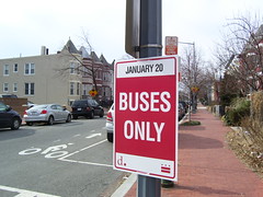
Please, someone say this sign was erroneously placed. This sign is at 3rd and R Streets NW.
I did find a new map (PDF) at the DC government’s inaugural site that gives the impression that there is charter bus parking up here, which may or may not explain the sign. But if it were for charter bus parking then there aren’t any no parking signs, which makes me think this may restricted to buses (ie excluding cars).
Day: January 17, 2009
1950s School Map

I also have the High School map and I can’t help but notice that 16th Street is a common dividing line.
This is from “Corning Sets Integrated School Zone Boundaries,” by Marie Smith, Washington Post, July 2, 1954 p. 1, 25-26. It is the proposed school boundaries for schools that were to integrate. Wanna guess what big demographic change occurs east of 16th?
Also I want to mention that when I present stuff from the past, occasionally called ‘history’, I will try to cite it so you dear reader can find the information yourself. History is subject to interpretation, and I bring my own biases. Un-cited, history is subject to being made up.