
So this comes up way too often. So that’s why I decided with this re-boot (messy as it is) that I would call the In Shaw blog Truxton is in Shaw, because it is.
Here is the quick and dirty and maybe in later posts I’ll go deeper.
Bloomingdale is on the other side of Florida Ave, which used to be Boundary Street in the 18th century. Why Boundary Street? Because it was the boundary between the city of Washington and the county of Washington, in the District of Columbia. Bloomingdale, lovely as it is, was/is a suburban neighborhood, in the then county.
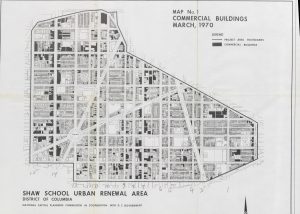
Shaw. I have yet, to find ANYTHING, anything calling the area we know as Shaw as “Shaw” prior to the late 1950s, and even then it was called the Shaw School Urban Renewal Area. See the map there? That is of the Shaw School Urban Renewal Area. Everything in it, is Shaw. The area known as U Street, you will see it, in Shaw. The portion known as Logan Circle, you can find it in the map, in Shaw.
Truxton Circle, look at the map, it is IN SHAW.
If it is in this map, it is in Shaw, which kinda stopped being a thing sometime after Home Rule and wards were a thing.