
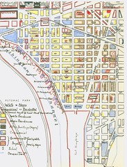
I got excited when I discovered this map from 1938. It is a hand drawn map of Southwest DC, much of which really doesn’t exist anymore. What it shows are negro and white commerical and residential areas as well as black occupied alley dwellings.
Demographic info is so cool.
I find it facinating because it further chips away at the ideas I had about Southern segregation. I always imagined it as very distinct, blacks on one side of town, whites on another and you won’t find one in the other’s neighborhood. My own (on again/ off again) study of Truxton Circle and this map shows a little mixture. The brown represents Afro-American street facing residences, black for black alley dwellings, and the yellow for white street facing residents. There are a few all yellow blocks, but there are plenty of yellow and black blocks, and yellow/ black/ brown blocks. The blue os commerical space.
6 thoughts on “Segregation Map”
Comments are closed.
Very cool! I love seeing how the neighborhood might have looked.
I really enjoyed reading *The Secret City; A History of Race Relations in the Nation's Capitol*? It's incomplete, but interesting study of the hidden history of DC neighborhoods and alleys. Love to see the 1st hand evidence!
What I found most interesting is that the dividing line between black & white was along the area that was formerly 4 and a Half street. The map features the area shortly after it was rebuilt. See the DC Cultural Tourism booklet[PDF] for more information on the area.
That is fascinating. I know that they must have had maps and such, in order to keep the segregation up. But it's so incredibly disconcerting to see it right there in front of me on a map.
I think this is an isolated map. It was for the Alley Dwelling Authority, drawn up by a SW resident or volunteer for a Southwest area group. I forgot for what the group was advocating. Believe me if there was a Shaw area map for this thing, I woulda found it.
I love historical finds like this. Tells us a lot about current issues/conflicts. I studied segregation for several years in grad school and it became clear that the way segregation played out physically varied widely by city. The differences were due to social and historical factors like slavery where in southern cities like DC, blacks and whites lived closer to each other yet still segregated.
Sorry but you have to sign your name. And today I'm just not in the mood for anon comments. And also DC is too inland and too far north (too cold to sustain a hurricane) to make Katrina-like comparisons.