
Okay, I gotta book that I checked out of the library and I’ma goin’ to use it. The book is Truxtun of the Constellation by Eugene S. Furguson.
I am inspired to write for two reasons one is an article from the WP columnist John Kelly, “There is no Washington, DC– but I’m not renaming my column” and an Examiner article about the TC. In the John Kelly piece, if completely accurate supports my suspicion that people in the last few centuries weren’t sticklers when it came to place names. Federal City, Washington City, same diff. When the most accurate official and legal name isn’t high on your list of priorities sloppiness may occur. The punishment for sloppiness is that long after the responsible generation is dead later generations get to nit pick.
Seriously, someone find me PROOF, actual f*ing primary resourced proof that the Shaw neighborhood was named DIRECTLY after Robert Gould Shaw, and not the Shaw Junior High School, which was. Because prior to the 1950s I can’t find a bit of proof that the neighborhood was even called Shaw, as a neighborhood. Mid City and northwest are the only names that seem to pop up prior to the Shaw School Urban Renewal Project. I am not counting the school districting.
So, ’round the turn of the century there was the Truxton Circle (named for Thomas Truxtun) at Florida and North Capitol. I’ve heard talk that the actual circle was in Eckington. But since streets act as borders, I’m going to say it was bordering West Eckington and Old City. Eckington is a suburb of the City (of Washington).Using the journal Washington History Volume 14, No. 2 as a guide, there is Eckington(1887), Center Eckington (1891) and West Eckington(1891). These sub-divisions are on the other side of Boundary Street/ Florida Avenue and the City residents have just as much claim to the traffic circle as the Eckington and Bloomingdale(1889) ones.
So the Truxton traffic circle was a traffic hazard and it went away. But then appeared a Truxton Post Office. On Florida Avenue, NE, not helping my argument. And then sometime in the 60s or 70s it closed. Then in the 60s came the Shaw School Urban Renewal Area project of which the TC is a part of, but it appears there was no reason to call our part Truxton Circle. Then came the Ward & ANC system in the 70s where Shaw was divided, having most of Shaw in Ward 2 and the TC in Ward 5. In the late 80s when the District government was selling houses and bringing in cable, they referred to the area as Truxton Circle.
Next Ten Days of Truxton: Slavery.
Tag: SSURA
Truxton Circle in Shaw
Shaw and Truxton as a concept
Maps from the mid 19th century do show some settlement in the area presently known as Shaw[1]. But the structures are clustered along a few main roads while other areas, like modern day Truxton Circle, are empty with a few isolated lonely structures.
As time progressed the population of the area grew. However, there is little to no evidence of any particular neighborhood name such as Shaw existing prior to the urban renewal project in the mid 20th century. Despite a circle there is no evidence of Truxton Circle as a neighborhood name, rather it was a landmark that things were “near” [2].
Prior to the Federal government’s National Capital Planning Commission, along with the RLA (Redevelopment Land Agency), creation of the Shaw School Urban Renewal Area, the name Shaw was associated with the Jr. High. It’s application to any particular area could be stretched with the application of that school’s borders which was established in the 50’s [3]. As part of the Redevelopment Act (of 1961?) the National Capitol Planning Commission defined the borders of what is modern Shaw as the Shaw School Urban Renewal Area. See this map from 1970 to see what was and what wasn’t Shaw [4].
Truxton in Shaw
In 1969, a grad student working with MICCO, Model Inner City Community Organization, in Shaw, noticed, “Concentrations and/or differences in land uses, physical conditions and building types, income property ownership and race coupled with identifiable places of community activity, all combine to suggest several communities within the Shaw area (see map 3).” One of the communities Mr. Reginald Wilbert Griffith mapped out in his MIT dissertation, fits the outline of Truxton Circle [5]. Also another smaller community within Shaw acknowledged it was in Shaw. In 1973 in a report submitted to RLA in the introduction, the first sentence reads, ” The Logan Circle Historic District is a unique assemblage of 154 Victorian buildings located in the Shaw School Urban Renewal Area”[6].
Unfortunately Truxton is separated from the rest of Shaw by Ward boundaries. The majority of Shaw is in Ward 2, while Truxton is in Ward 5. These political boundaries also reflect police districts, most of Shaw being in the 3rd district and Truxton in the 5th. So with these political boundaries, determined by census data, like congressional districts, it may give the false appearance that Truxton is it’s own separated neighborhood.
Okay, I’m not really interested in adding anymore footnotes, so I’m stopping. Disagreeing commenters can talk about their feelings and opinions which are neither evidence nor proof. In the arguments about borders and such it seems no one bothers doing research. Claims with out anything to back it up is just bull.
Messy Footnotes-
1. Map of Washington City, District of Columbia, seat of the federal government : respectfully dedicated to the Senate and the House of Representatives of the United States of North America / surveyed and published by A. Boschke C.E. from the Library of Congress. Circa 1857.
2. SALE OF SIX HOMES SHOW PRICES HIGH The Washington Post (1877-1954). Washington, D.C.: Apr 27, 1919. p. R6 (1 page) and $110,500 IN SALES OF HOMES IN CITY; Houses Fetch $17,500 Disposed by Hartung & Gibbons. The Washington Post (1877-1954). Washington, D.C.: Nov 7, 1920. p. 34 (1 page).
3. “Corning Sets Integrated School Zone Boundaries,” by Marie Smith, Washington Post, July 2, 1954 p. 1, 25-26.
4. NCPC File No. UR-07 “Resolution Modifying the Boundaries and Urban Renewal Plan for the Shaw School Urban Renewal Area”; File UR 07 Modification #6 NDP 2; Records Relating to Urban Renewal; National Capital Planning Commission (1952-), Record Group 328; National Archives Building Washington, DC: and SHAW SCHOOL URBAN RENEWAL AREA District of Columbia. As adopted by the National Capitol Planning commission and approved by the District of Columbia Council through March 29, 1973. N.C.P.C Map File 31 20
5. “The influence of meaningful citizen participation on the urban renewal process and the renewal of the inner-city’s black community: a case study – Washington, D.C.’s Shaw School urban renewal area – MICCO, a unique experiment.” by Reginald Wilbert Griffith 1969. MIT, Cambridge, MA
6. “The Logan Circle Historic Preservation Area: Summary if a Report Submitted to the RLA” by Turner Associates, P.C. and Nicholas Satterlee & Associates. Summary prepared October 1973. (Possibly from the National Archives RG 328, National Capital Planning Commission, unknown series, box 92, no file.)
SSURA history
SSURA-Shaw Urban Renewal Area
I’ve been tearing up the house trying to find an eyeglass perscription among the piles of paper that litter my house. One of the piles was ‘neighborhood history that I’ll blog about at some point’. As I wait for a bunch of podcasts to download, I’ll type out this find. It is a transcript from the National Capital Planning Commission’s Executive session March 3, 1966, starting around page 42:
Chairman Rowe
Now we get to this review, Mr. Conrad, of the proposed urban renewal area in the Second Precinct around the Shaw School. Would you give us the background.
(Mr. Roberts departed the meeting at 4:55 o’clock p.m.)
ITEM NO. 4- SHAW SCHOOL URBAN RENEWAL AREA
MR. CONRAD: In 1958 the staff prepared a general neighborhood renewal plan in the Second Precinct area which is about the same area as you see encompassed by the red line on the map on the board which was 14th Street to the west, Florida Avenue to the north, North Capitol Street to the east and then down to Massachusetts Avenue and 10th Street on the south.
This is a rather large area. It contains about, oh, I believe nine to 12 projects that were supposed to be done over a period of ten years but were very limited when we went into the study of this area.
We were limited because of the housing tools that were available at that time. We were also restricted because of the high cost of rehabilitation and no write down to the process of urban renewal at that time. We were also restricted because there was very little citizen interest in this area.
As a result the large area was cut down to what the Commission knows as Northwest Number One which is about a 76-acre project which we have approved and which the Redevelopment Land Agency now is carrying out.
Since 1958 there have been quite a few changes. It is possible to get write down on rehabilitation. There is the 221-d-3 moderate cost housing, relocation housing. There are new forms of public housing which we have. The President is coming up with a demonstration city where we should get larger areas in order to be able to stage the development. Also the Shaw School has come into its own as a need and the President has also pointed out the examples where we should take schools and make them examples for other cities and this is a wonderful location to do it.
So last week Mrs. Rowe, three District Commissioners, Walter Washington, the staff and also some citizens from this area got together and now the citizens are asking for public help to do something with their area.
Reverend Fauntroy was there representing the area as well as Mr. and Mrs. — was that Lawson?
CHAIRMAN ROWE: Judge Lawson.
MR. CONRAD: Judge Lawson. They feel that the citizens are ready for this and they are looking for help from the proper public bodies.
We are working with D.C. on this as well as the Redevelopment Land Agency and we propose to come back to the Commission at its next meeting in April with specific boundary lines for approval so that we can go in for planning advances to at least study this area for urban renewal.
There is more but this was long enough and the keys on my keyboard get kind of sticky.
Age of a neighborhood
Reading through the digest versions of the MVSQ listserv* I noticed an announcement by Alex Padro for an event today at the Historical Society. Yet in his introduction, “Come explore the changing streetscape of one of Washington’s oldest neighborhoods…” bugged me. How old is Shaw? With some other neighborhoods the age is a no brainer. LeDroit Park and Eckington were built by developers and you just track the date down to the developer. Georgetown, was a town, with a town government.
With Shaw, there were houses and people in the area prior to the Civil War. But so far in my own dabblings I haven’t seen any reference to the area as ‘Shaw’ until the mid 20th Century. And the earliest was at best the boundaries for Shaw Jr. High, never mind the elementary schools and the high schools. Trying to tie it down by civic/citizen associations haven’t been helpful. Back when the ECCA (East Central Civic Association), played a real role in city life, it’s boundaries were all over the the place. But regardless, it did include great parts of present day Shaw east of 7th, as well as the Sursum Corda area, and eastern Mt Vernon Sq., and it’s an early 20th Century thing.**
So, how old is this neighborhood? How is that age determined and what is it based on?
*Believe me you’ll find listservs more manageable and keep your sanity by getting some discussion lists in one daily email.
**”East Central Civic Group Seeks Vote :Improved Housing, Clean Block Drive Also on Program.” The Washington Post,p. 17. 12/7/1940.
When your scanner is limited
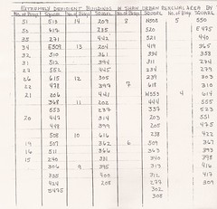
The picture is of a legal sized document. Sorta circa 1970 from the same folder as the legalese I wrote yesterday. The problem is my scanner can’t get the whole page.
What is this?
“Extremely deficient buildings in Shaw” aka number of crappy buildings that probably need to be torn down. I see Square 513 had 51 crappy buildings. Square 513 is N St, 4th St, M St, and 5th Street. Well considering the post 1970 buildings on that square and the building that committed suicide last (or was it early this year?) year…. yeah. Next on the crap for bricks block is Sq. 617 with 50. That’s over with Hanover Pl, and then Sq. 271 with 35 buildings. My little map O’Squares only covers eastern Shaw, so I don’t know where that is without doing some more looking.
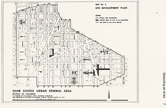
April 2, 1970 borders of Shaw
From page 2 from the memo NCPC File No. UR-07 “Resolution Modifying the Boundaries and Urban Renewal Plan for the Shaw School Urban Renewal Area”; File UR 07 Modification #6 NDP 2; Records Relating to Urban Renewal; National Capital Planning Commission (1952-), Record Group 328; National Archives Building Washington, DC:
BE IT RESOLVED, that pursuant to Section 6(b) and 12 of the Redevelopment Act, the Commission adopts modified boundaries for the Project Area described as follows:
Beginning at the southwest corner of the intersection of Fifteenth Street, N.W., and “N” Street, N.W., thence along the south line of “N” Street, N.W., the the southwest corner of Thirteenth Street, N.W., and “N” Street, N.W., thence southerly along the west line of Thirteenth Street, N.W., to the southwest corner of “M” Street, N.W., and Thirteenth Street, N.W., thence along the south line of “M” Street, N.W., to its intersection with the north line of New York Avenue, N.W., to the east line of North Capitol Street, thence along the east line of North Capitol Street to the northeast corner of North Capitol Street and Florida Avenue, N.W., thence along the northeasterly and north lines of Florida Avenue, N.W., to the northeast corner of Florida Avenue, N.W., and Georgia Avenue, N.W., thence along the east line of Georgia Avenue, N.W., to the north line of “V” Street, N.W., extended to the east line of Georgia Avenue, N.W., thence along the north line of “V” Street, N.W., extended to intersect the east line of Florida Avenue, N.W., at Ninth Street, N.W., thence in a northwesterly direction along the east line of Florida Avenue, N.W., to the east line of Sherman Avenue, N.W., thence northernly on the east line of Sherman Avenue, N.W., to its intersection with the north line of Barry Place, N.W., thence westerly on the north line of Barry Place, N.W., to its intersection with the north line of Florida Avenue, N.W., thence along the north line of Florida Avenue, N.W., to the intersection of Florida Avenue, N.W., New Hampshire Avenue, and Fifteenth Street, N.W., to the point of beginning.
Good Lord, that is the most confusing piece of geo-legal-gaaaaah I’ve ever transcribed.
Some Make Stuff Up, & Some Bring Proof
I have a laundry list of 1/2 done projects. At work there is the ‘paper that should have written itself,’ but noticeably didn’t. At home there is the 1900-1930 census project, which at the pace I’m going will be done in time for the 1940 census to be rolled out. And way down on the list is correct that damned Wikipedia page on Shaw. Because I want to actually cite sources, the problem is trying to figure out the coding (which I know shouldn’t be that hard) to cite the sources to prove that most of the history written there is a load of horse manure. I’m reminded of this everytime the question of where the borders of Shaw are comes up, like with DCist .
Maybe I’m too timid when it comes to over writing something that someone else wrote. But then again, I have to ask ‘prove it’. The other problem is that I’m a bit shaky and not particularly sure on a comment I wish to make saying that the neighborhood wasn’t called Shaw prior to 1950. Okay I actually want to say 1960. However there was a school boundary but as a neighborhood in general I haven’t come across any pre-1950 lit saying otherwise. But just because I haven’t come across it doesn’t mean it such evidence doesn’t exist, and that’s what concerns me.
So in my mind, the TC is part of Shaw, as it was a federal agency and the DC government that came up with the borders. Yet, people keep doubting and throwing out ideas with no proof or anything to back it up.
Correcting the damned page just moved up again.
Urban Renewal: So what were you thinking?
I’ve been meaning to getting around to talking about a lovely record group at the National Archives. If you go to their OPAC called ARC and throw in the phrase “National Capitol Planning Commission” you will find a slew of series that pertain to the history and development of the District of Columbia. Records Relating to Urban Renewal (ARC ID# 784266) do contain a lot of info about Shaw and other areas that got ‘renewed’ in the middle of the 20th Century. Another series I want to focus on in this post are the Transcripts of Proceedings and Minutes of Meetings, 01/1924 – 12/02/1999 (ARC ID# 1571319).
At the 1962 September Open Session Meeting of the Commission (9/13/1962), when speaking about the Northeast No. 1 Urban Renewal Project, Brig. General F.J. Clarke made the statement:
Urban Renewal, as presently thought of, may be separated into 2 principal categories: First, being those actions which are concerned with preventing future slums, namely improved planning, improved codes, etc.; and, 2nd, the elimination of existing slum or blighted areas.
In this category of eliminating existing slums, the primary purpose of urban renewal is the elimination of slum or blighted areas by various means: acquisition and demolition of structures; the rehabilitation of existing structures; installation of public facilities, and other measures.
Secondarily in purpose but not in importance is the prevention of the recurrence of slum and blighted conditions again in the redeveloped or renewed area.
There’s more, but I don’t feel like transcribing it right now. It points a bit to the thinking of the ‘why’. It’s getting to the what, that makes things interesting.
Are we there yet?
In the 50s-60s the Feds and locals came up with the Shaw School Urban Renewal Area (SSURA) plan. My question, it being 2007 and all, well I was wondering, are we done yet? Has Shaw been urbanly renewed? Or is it one of those government things that will never die and 30 years from now Shaw will still be renewing? Is there a DC neighborhood that has been renewed and the authors of it have placed their hands on their hips, struck a profile, and announced that their work is now done? If so did they get what they planned for?
Slummy history
Okay I think I now know what direction I want to go with my blogging. I have been thinking of ending InShaw, as we know it, sometime next year. Well I might just put InShaw in semi-retirement, just reporting on the TC side of things and things close to the TC borders. What I may replace it with is good old Shaw history since I’m finding the stuff I find so friggin interesting.
I’m not talking Victoriana or great people history. I don’t subscribe too much to the idea that history is a glorifying narrative, nah. To me it is an explanation of why this world is broken, and screwed up. Why my house was designed by crackheads. We hear the phrase ‘we read about history so that we may learn from it’, well this is what I’m learning, and I enjoy sharing it with you.
Looking for more info on the Shaw School Urban Renewal Plan, I found a master’s thesis from M.I.T. “The influence of meaningful citizen participation on the urban renewal process and the renewal of the inner-city’s black community: a case study – Washington, D.C.’s Shaw School urban renewal area – MICCO, a unique experiment.” by Reginald Wilbert Griffith, written in 1969. I want to thank MIT for putting out those papers that normally only 5 people tops (10 people for PhD dissertations) would ever see, because it is a jewel, even though it is a quite biased bit of work, or “limited objectivity on the part of the author,…”
The PDF file MIT provides to non-MIT people doesn’t allow printing, but it is worth the read for two bits that I found enlightening. One was a late 1960s description of the area on page 20:
The Shaw School area, named after an aged and dilapidated junior high school known as ‘Shameful Shaw’ is third in terms of the evolution of communities in the District of Columbia and was the fifth blighted section of Washington to be studied and the latest to be approved, for urban renewal. It was planned from a ‘black community’ and ‘advocacy planning’ point of view.
And on page 15, the author mentions “Concentrations and/or differences in land uses, physical conditions and building types, income property ownership and race coupled with identifiable places of community activity, all combine to suggest several communities within the Shaw area (see map 3).” However, he doesn’t try to name them, which I found frustrating.