From page 2 from the memo NCPC File No. UR-07 “Resolution Modifying the Boundaries and Urban Renewal Plan for the Shaw School Urban Renewal Area”; File UR 07 Modification #6 NDP 2; Records Relating to Urban Renewal; National Capital Planning Commission (1952-), Record Group 328; National Archives Building Washington, DC:
BE IT RESOLVED, that pursuant to Section 6(b) and 12 of the Redevelopment Act, the Commission adopts modified boundaries for the Project Area described as follows:
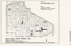
Beginning at the southwest corner of the intersection of Fifteenth Street, N.W., and “N” Street, N.W., thence along the south line of “N” Street, N.W., the the southwest corner of Thirteenth Street, N.W., and “N” Street, N.W., thence southerly along the west line of Thirteenth Street, N.W., to the southwest corner of “M” Street, N.W., and Thirteenth Street, N.W., thence along the south line of “M” Street, N.W., to its intersection with the north line of New York Avenue, N.W., to the east line of North Capitol Street, thence along the east line of North Capitol Street to the northeast corner of North Capitol Street and Florida Avenue, N.W., thence along the northeasterly and north lines of Florida Avenue, N.W., to the northeast corner of Florida Avenue, N.W., and Georgia Avenue, N.W., thence along the east line of Georgia Avenue, N.W., to the north line of “V” Street, N.W., extended to the east line of Georgia Avenue, N.W., thence along the north line of “V” Street, N.W., extended to intersect the east line of Florida Avenue, N.W., at Ninth Street, N.W., thence in a northwesterly direction along the east line of Florida Avenue, N.W., to the east line of Sherman Avenue, N.W., thence northernly on the east line of Sherman Avenue, N.W., to its intersection with the north line of Barry Place, N.W., thence westerly on the north line of Barry Place, N.W., to its intersection with the north line of Florida Avenue, N.W., thence along the north line of Florida Avenue, N.W., to the intersection of Florida Avenue, N.W., New Hampshire Avenue, and Fifteenth Street, N.W., to the point of beginning.
Good Lord, that is the most confusing piece of geo-legal-gaaaaah I’ve ever transcribed.