
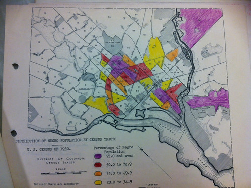
 If anyone can find or recreate the Washington DC redline map, that would be helpful, because no one seems to have it. There is a project to map restrictive racial covenants, but those seem to be a small amount of DC housing, rather than the majority. The image here is the distribution of African Americans or Negroes, in DC in 1930, so probably close enough to a redline map.
Considering the map, Truxton Circle or as it was known then, Census tract 46, was more than half AfAm. If it wasn’t a redlined area, it may have been yellow, “Definitely Declining.” The area that became Shaw, ranged from 35% to over 75% black, which may have been too many black people for the Home Owners’ Loan Corporation (HOLC) map makers.
Using data from my TruxtonCircle.org project, I just took a look at the 1930 and 1940 census data*. In 1930, of the heads of households, there were 1109 renters in the TC and 310 home owners. Of those who owned 237 were black. In 1940, there were 1442 renters, 269 home owners, and of those owners, 218 were black. So most people in the TC were renters and African American home owners were a majority of a minority of people.
So who were these Negro home owners? A lot were a variety of government workers (federal and DC schools), service workers (chauffeurs, Pullman workers, waiters) and professionals (doctors, ministers, lawyers) . I’d say the black middle class and prudent working class folks. The same people who’d engage in black flight in the 1970s and 1980s.
*I’m still cleaning up the data.