
Turtle Girl seems to have found something. My former supervisor’s daughter just got a job working at National Airport and needs a place to stay. I’m calling said daughter Turtlegirl, because she likes to stay in her room on her computer. For some people she’d make an excellent roommate mainly for her keen staying the hell out of the way & being quiet superpowers. Like the mighty turtle she tends to retreat into her shell. She’ll need to emerge for heating food up, laundry and hygienic activities.
If my room were available I would house her, but alas it is occupied by someone else. So I am calling out to those of you in Shaw or at least a 10 minute walk from a yellow, green or blue line station who is charging less than $800 and has Internet, cable, washer and dryer and kitchen privileges. Please email me – mari at inshaw dot com if you have room for Turtlegirl.
Day: September 9, 2009
Segregation Map
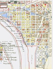
I got excited when I discovered this map from 1938. It is a hand drawn map of Southwest DC, much of which really doesn’t exist anymore. What it shows are negro and white commerical and residential areas as well as black occupied alley dwellings.
Demographic info is so cool.
I find it facinating because it further chips away at the ideas I had about Southern segregation. I always imagined it as very distinct, blacks on one side of town, whites on another and you won’t find one in the other’s neighborhood. My own (on again/ off again) study of Truxton Circle and this map shows a little mixture. The brown represents Afro-American street facing residences, black for black alley dwellings, and the yellow for white street facing residents. There are a few all yellow blocks, but there are plenty of yellow and black blocks, and yellow/ black/ brown blocks. The blue os commerical space.