Property Owners of Truxton Circle- Edward D. Coleman

Landowner list of Sq 551Okay this is a very quick one. In the 1933-1934 General Assessment Edward D. Coleman (1901-1942) was listed as the owner of Square 551 lot 852. He and his wife Florence sold the lot in 1936 to Lillard (that’s an interesting name) Fields. This was another Reeves Alley property so I can’t really get a good address.

In the 1940 census Edward D. Coleman was a white 38 year old self-employed Real Estate Agent from Illinois. He lived at 1634 Monroe St NE with is wife and their 3 minor children.

Property Owners of Truxton Circle- Robert Martz

The problem with the Census is that sometimes the street isn’t clear. For a moment I thought the Martz family lived in Truxton Circle on R Street. However, looking at adjoining pages I figured out what Ancestry.com decided was a R in R St was actually K. The other thing was that I found the owner of Square 0551 lot 0851 (a wood structure in Reeves Alley) in the 1933-34 General Assessment was a family tree that did not know he had children.

Looking at the land records Robert William Martz bought the property, listed as old lot 19 in 1932 from John W. Hile. Then in 1935 he died in Clarendon, VA at the age of 46. His widow, Ethel Marie Lewis Martz (1895-1977) appears to have sold the property in 1942 to Paul J. Bower, who then sold the property to Embassy Dairy in 1947.

Square 551 (bounded by R, Florida, 1st, Q and 3rd Streets) was a mix of residential and commercial properties. In the 1930s Robert W. Martz was a coal and ice man running his own business. Since this property was in Reeves Alley as far as I can tell this could have been used for commercial reasons related to his business.

He did live at times in Washington, DC but not in Truxton or the Shaw areas.

I mentioned I wish I could amend or add to the family tree that left the Martz’ childless. Robert Martz (1889-1935) was survived by 3 children at the time of his death, Robert Jr. (1918-1999), Marie Ethel (later Marie Graham 1920-1990), and Catherine Elizabeth (later Thorpe, 1922-2009).

Property Owners of Truxton Circle- The Keysers and Ms. Harriet Crowell

Next on the list, as I go down it, is Sq. 551 and lot 850. Sigh, lot 850 is part of old lot 19, so this is going to be confusing. I’m just going to start with the land records and see where that takes me.

Searching for just lot 850, only two documents appear. The first is from 1947 between a Charles F. Wilson, trustee in Civil Action case file 38-115, and Embassy Dairy. The other is in 1948 for an easement/ right of way between the DC government and the Office of the Surveyor.

Another search with lot 0019 drags up the Leviovs, and Ms. Carrie Walker. The first document regarding the Kaysers is a deed from 1927 regarding the execution of the will of Esther A. Kayser by Caroline E.T. Knox and Elhanan Winchester Keyser. There are other relatives such as Harriet Esther Kayser Crowell, mentioned in the deed but it is oh so confusing with Kaysers and Keysers. To Ancestry! Continue reading Property Owners of Truxton Circle- The Keysers and Ms. Harriet Crowell

Property Owners of Truxton Circle- Carrie G. Walker

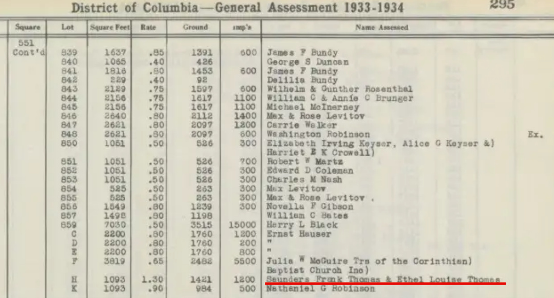
My first question with this was, is Carrie Walker a man or woman. I need to know because it makes the searching in Ancestry easier. The property records has Carrie G. Walker, the daughter getting the land from Carrie Walker. The 1920 census, sigh, has Carrie Walker as the female head and Carrie G. Walker as the wife.

This is a misstatement.  A few fields over, the senior Carrie is listed as a widow and the junior Carrie as single. Looking at the 1900 and 1910 Census shows John Walker as the male head, Carrie senior as the wife and Carrie G. junior as the daughter. Okay, a reminder that the Census screws things up time to time.

Also from the census, I see the Walkers are African American resident owners (mullato/negro) living on R St NW. Later I could re-do this as Black Homeowners of Truxton Circle. They were at 216 R St NW in 1900 and Mr. Walker was the owner. In the later 1910 and 1920, the Walker family lived at 146 R St NW, square and lot 0551-0847. Did the address change or did they move? No idea.

The earliest land record I can see is from 1924 between Carrie G. Walker (the younger) and Needham C. Turnage to borrow $280.00 with 146 R NW as security. Then there are a series of loans she takes out using the property as collateral. So loan #1- 1924 Needham Turnage $280.00. Released (paid) 1938. #2-1926,  Kahn and Coleman/ Leo Kahn & E. Coleman, $375.00. Released 1927. #3- 1936, James B. Evans & Claude W. Owen, $372.00. Released 1938. #4- 1938, Washington Loan and Trust Company, $800.00. Released 1950. In 1951, she sells the land to Lawrence C. and Rosa A. Diggs.

Side note, a Carrie E. Walker buys 112 Florida Avenue NW (SSI: 0551-0178) in April 1934 from William H. Coates and Mamie D. Coates. A search for Carrie E. Walker in Ancestry is not particularly fruitful. The name does not change for the brief moment Carrie E. owns it, as she sells it 2 months later in June to Mary E. Baker.

Find Your Own Owners of Where Ever DC

Let’s call this an SOP, standard operating procedure, for what I’m doing. And what am I doing? I’m doing some neighborhood history, but more along the lines of neighborhood historical fact gathering. History is about a story to be told. The problem is that I get another piece of information and it kinda throws a monkey wrench into the narrative. Here I gather the info, then try to tell a tale.

For this series- Property Owners of Truxton Circle, which could later apply to Black Home Owners of Truxton Circle, there are a couple of resources I use to find out about the owners. Continue reading Find Your Own Owners of Where Ever DC

Property Owners of Truxton Circle- Michael J. McInerney

Image not found
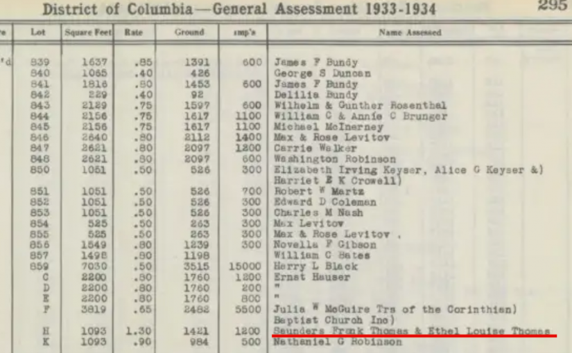
So in our last entry regarding the Brungers there was the issue of Sq. 551 Lot 17, which was also lots 844 and 845. Sometimes, I imagine that I will make a corresponding spreadsheet of addresses by also linking them to their SSL (square and lot) numbers, but then I have to deal with this problem of lot numbers changing. It happens now too with condos. The owner I’m looking at today is Michael Joseph McInerney Sr., owner of lot 845, which appears to be 208 R St NW. And for those of you just joining in this series, this house no longer exists.

Another issue I keep coming across are landowning dead people. The source that I am using is the Washington City General Assessment 1933-1934 for a section of Square 551. So these were the names the city went after to pay property taxes. And like my aunt in SE who’s been dead for about 10 years, she’s still paying property taxes. Well, her estate is, but her name is still on the property, just like Michael McInerney in 1934, who died in 1925. Continue reading Property Owners of Truxton Circle- Michael J. McInerney