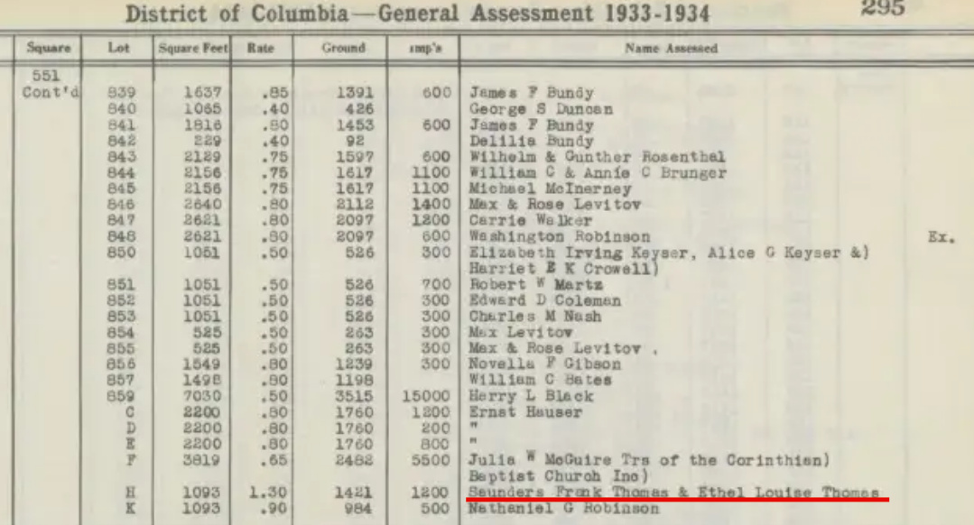
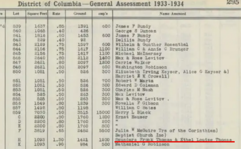
Once again- The historical boundaries of Shaw

Okay so there is a write up in the Washington Post about Shaw. I’m debating about giving Alex Padro a hard time about the east boundary being New Jersey Avenue. Their graphic has Shaw’s western boundary at 13th St NW and the southern part just eats up Mt. Vernon . The boundaries of Shaw keep changing with each article so, there is that. This is a Real Estate article, and they quote Padro and Ibrahim Mumin, so I’m not going to nit pick much, except for this point.

Anyway, here’s a map

map of Shaw and CHand this gem

Commercial Building Map
Map of Shaw for 1970 Commercial Buildings

and this…

Proposed subway line through 1968 Shaw

The Triangle Known As Truxton Circle- Frankenmaps

Back in 2017, I and two artist neighbors set up an exhibit at 410 GoodBuddy called The Triangle Known as Truxton Circle. I have a few things sitting on my computer from the exhibit that I’d like to share. Between no childcare and attempting to telework in less than ideal conditions, yes, I’m not posting much. But I can post this from the exhibit.

Below are two maps I created from older maps. The thing was none of the old fire maps had Truxton Circle on one map. I had to piece the maps together from several maps, just as Dr. Frankenstein pieced together his creature. I sold the older view of the TC and have kept the 1919 map for myself.

Frankenmap 1887

2016, Giclée Paper Print on Bamboo

Son of Frankenmap 1919

2016, Giclée Paper Print on Bamboo

These are two maps of the same area. The lighter colored map used maps from 1887, the earliest real estate plat maps covering the area. There are many empty lots. The rose /yellow colored items are houses or other structures where real people lived and worked. The darker map is made of 1919 maps. The later map shows a neighborhood filled with brick houses.

If your home is older than 1919 can you find it on the map?

Do you notice other differences between the 1887 and 1919 maps?

The Triangle Known as Truxton Circle: Stick a Pin in It!

Back in 2017, I and two artist neighbors set up an exhibit at 410 GoodBuddy called The Triangle Known as Truxton Circle. I have a few things sitting on my computer from the exhibit that I’d like to share. Between no childcare and attempting to telework in less than ideal conditions, yes, I’m not posting much. But I can post this from the exhibit.

Map-of-TC-Commerce

PIN ME!

If your house existed in 1970, please take a colored pin and stick it on your house.

One pin per household.

Triangle Known As Truxton Circle: Bulldoze a road through it

Back in 2017, I and two artist neighbors set up an exhibit at 410 GoodBuddy called The Triangle Known as Truxton Circle. I have a few things sitting on my computer from the exhibit that I’d like to share. Between no childcare and attempting to telework in less than ideal conditions, yes, I’m not posting much. But I can post this from the exhibit. First is the image then the exhibit text. Enjoy.

Freeway Plan circa 1957-1960

2016, Digital Print on Foamboard

This is a map of what could have been. It is an undated planning map from the National Capital Planning Commission. Truxton Circle is the upper green area of the map. In this version I-395 does not stop at New York Avenue but continues north to meet with a planned east-west freeway between P and U Streets.

Do you know why I-395 ends where it does?

Who would these freeways serve?

If the freeway didn’t stop at New York Avenue, would your house still exist?

Truxton Circle Population 1880-2010

So I was cleaning up and found this and decided to post this helpful table.

Truxton Circle Population 1880-2010
Year Total Black White Other/Asian Note
1880 1511 678 832 0
1900 4723 2438 2281 4
1910 6801 2232 4565 4
1920 7234 3008 4221 6 4-Chinese
1- Japanese
1- White/Chinese
1930 6175 4455 1712 6 All Chinese
1940 8244 6519 1718 4 Note: 3 Japanese
1 Chinese
Total also 8244
1950 7720 6186 1511 23
1960 6789 6716 58 15
1970 5830 5768 21 41 2 yrs post riot
1980 3349 3249 61 39
1990 3623 3347 189 87
2000 2997 2713 103 181
2010 3028 1964 816 248

Source: US Census


Black Homeowners of 3rd Street – 1940 No covenants

It has been a while since I looked at the Black Homeowners of Truxton Circle. I stopped because I got stuck on a mystery and I’m just going to have to let it go. I will never know who the mystery man was and that’s okay. I’m going back to the Black homeowners because of on-line conversations with Richard Layman and things I’ve been reading about redlining and restrictive covenants.

Old City, DC Police districts

In my own research, I have not seen any restrictive covenants. I believe it is a thing that would be found outside of the L’Enfant planned city and in Washington County, those areas north of Florida Avenue. Mt. Pleasant, Trinidad, and Bloomingdale are the creations of developers who could put in those restrictions. So if you lived in Old City, the likelihood that your fee simple house (apt buildings could be a different thing) had a racial restriction would be low.

When looking at the property records, I have tried to make heads or tails out of them, but they are beyond me for now. I’ll see person X seem to transfer to person Y , then years later Z shows up with X. With E.L. Haynes who owned my house and several other properties in Truxton Circle and DC, she was able to borrow money for her rental properties. The financial details are in her papers at Catholic U’s archive and not so much with the Recorder of Deeds. Anywho, Black people managed to borrow money from somewhere to purchase real estate. Banks practicing redlining weren’t the only game in town.

Below is a table with data from the 1940 census, I’ve had to cut a lot out so it could fit, but know they are all for 3rd Street, they are all owners and African American.

House # Surname First name Age Marital Status School Occupation Industry Income
1311 King Cornelius 59 M H-4 Casterman US Printing Office $1,859
1335 Brown Hillary I 40 M 7 Janitor Apt house $936
1337 Turner Anna 37 M H-1 Waitress Tea room $320
1413 Taylor Emma 46 M H-3  $-
1415 Mudd Harry 60 M 8 Machinists helper Railroad Terminal  $1,900
1429 Aiken James W 48 M H-4 Waiter Hotel  $520
1430 Neal Victoria V 69 W H-4  $-
1431 Anderson Ada 79 W 6  $-
1538 Fitch Lula 45 M H-2
1542 Green William M 40 M H-1 Laborer Gov’t Printing Office $1,320
1544 Williams Augustus A 56 M C-5 Dentist Private Practice $2,000
1546 Brooks Walter A 54 M C-3
1548 Chisley Sadee 62 W 6
1550 Blackwell James 45 M 0 Cement Finisher Cement Contractor $960
1554 Taylor Walter J 65 M 8
1617 Contee Grant 63 M 0 Preacher Ministry  $-
1626 Cobbs Ferrel 45 M H-1 Messenger Interior Dept  $1,260
1628 Coleman Edward 60 M 8 Messenger Veterans’ Bureau  $1,500
1629 Jenkyns Jerome S 61 M C-8 Machinist U.S. Government  $2,245
1630 Marsell William 50 M 8 Custodian Bureau – Standards  $1,140
1649 Heywood Spencer 50 M C-1 Barber Barber Shop  $900
1634 Ford Laura 54 S 4  $-

I highlighted 1649 3rd Street, because that was my hang up, but I’m letting go, letting go. Instead I need to figure out how to make a decent table. This doesn’t seem like a long list, but remember in urban areas, more people are renters.

The owners on 3rd Street NW are varied. There are government workers, widow women, skilled labor and an educated professional. The youngest is Anna Turner, a 37 year old waitress at 1337 3rd St NW. She lived with her son and a female lodger, a teacher, the eldest a 79 year old widow Ada Anderson.

At the DC Archives- Shaw School Urban Renewal

It has been a long while since I checked in on the DC Archives. I have opinions, but as I get older I know I should keep them to myself, for professional reasons, as my day job is in the field. What I will say is that I find it frustrating that there isn’t more available to the public on-line, the long promised new building has yet to be built, there are records that logically should be open that aren’t, and DC government agencies seem to be unclear as to where their records are.

Okay, now that’s off my chest.

I checked in on the DC Archives on-line to see if there was any improvement since the last time I went looking for something. The answer was yes, there was some improvement. One of my biggest complaints was that they didn’t have a decent catalog. You see many small archives are at universities and colleges, so their stuff sometimes sit on school library website, and librarians are super duper stars at getting information to the public. State archives vary. Some states are better than others, but there is usually a catalog. There are companies out there, go to an ALA conference, or even SAA and you will find companies that have catalogs with public sides, so the public can see what the heck you have. But if you’re too cheap/wary for that, there is always throwing PDFs of finding aids on your website.

One of those fine PDFs is for the Shaw School Urban Renewal District Case Files, 1967-1968. I have heard tale of this survey. What would be interesting is to see what buildings were found to be derelict in the 1968 survey that still stands today and has been renovated and if any had been demolished. What I find most useful is the list, on the last page, of all the squares in the Shaw neighborhood.

map of Shaw and 14th Street NW

Truxton Black History Link- Dunbar Cadet Corps

Right now the Library of Congress website is being very uncooperative. They have photographs of Dunbar High School girl cadets from the 1940s. So instead I’m going to link to someone else’s old blog post about the boys’ cadet corps circa 1950-1960.

It’s a pretty good post with photos from the Dunbar High School year book describing what the cadet corps did and their history. The author, Marion Woodfork Simmons,  said that the cadet corps was the precursor to the JROTC. My niece is in the JROTC at our (I & her mom – my sister- went there too) Florida high school. She’s interested in the Navy. Anwho, it seems Dunbar still has an JROTC program.

It’s Black History Month- Blame Shaw’s Own Carter G. Woodson

Carter G. Woodson statue at night
Memorial for Dr. Carter G. Woodson at 9th and RI Ave NW.

It’s February so that means it’s Black History Month. And eventually somebody says something about February being the shortest month of the year and African Americans getting short shrift. Which is really ignorant because the “Father of Black History” Carter G. Woodson picked a week in February for Black History Week. That week turned into a month and that brings us to where we are. He could have picked another week in another month, but he didn’t. Please shaddap about February.

Dr. Carter G. Woodson (PhD, Harvard, 1912) noticed there was a lack of history documenting and telling the story of Black Americans in America. So he saw a problem and then fixed it. Quoting the NPS biography of Dr. Woodson, “The public knew very little about the role of African Americans in American history, and schools were not including African American history in their curriculum. He worked tirelessly throughout his life to remedy this problem, becoming nationally recognized as “the Father of Black History.” ”

Dr. Woodson lived and worked at 1538 9th Street NW, which is in Shaw. This would explain the statue, if you missed it, at 9th and Rhode Island Avenue NW. And the National Park Service complex at his historic home’s location. And of course, there are programs going on this month to celebrate the man. On February 15th and 29th at 1PM an actor will lead a 3 hour tour (a three hour tour) in the life of Dr. Woodson. The historic house is regularly open 3 days a week, Thursday through Saturday, 9 to 5.

Bad Lady Lawyer Story

To my lawyer friends, don’t worry. The lawyer in this story is long gone and the profession has long moved on from the kind of exploitation this chick engaged in.

History has a billion stories. Many stories fit in or tie in with the grand narratives, some better than others. This story involves a African American widow who lived in Shaw and a bad questionably moral white female lawyer.

July 16, 1916  Washington Post reported the death of Sergent Major George R. Garnett, a retiree from the Bureau of Engraving and Printing, who died at home at 1743 11th St NW in Shaw at the age of 63. Two days later there were funeral arrangements at Metropolitan Baptist Church and he was buried at Arlington Cemetery.  He left behind his wife Virginia (nee Robb) Garnett.

A few days after his death, Ms. Rose M. Sefton, listed in the city directory as an Claim Agent, visited Virginia Garnett to “help” her get a widows pension. Looking at the pension record it the story gets really confusing. Sefton with a notary in tow, came over to 11th St. NW to get Mrs. Garnett to sign papers to allow Sefton to collect a $25 attorney’s fee for “helping” the widow. Sefton was not entitled to $25, which would have come out of whatever pension Garnett received. Mrs. Garnett claimed that she did not have her reading glasses on the day Sefton visited and thus could not read all the papers she signed that day. Later the Pension office investigated and suggested Sefton be disbarred. However, I’m not sure Sefton ever passed the bar to begin with. In the pension papers she calls herself an attorney.

Sefton’s actions just seem shady. She swoops in before the body is cold, gets the widow to sign a bunch of papers to collect the maximum fee (it should have been $15 dollars) which was to be taken out of the widow’s pension. It’s not like Garnett went looking Sefton.

I can’t find evidence of Mrs. Garnett’s death. I did find her in the 1931 City Directory. She had moved from 11th Street to 930 P Street NW. Ms. Sefton died on Boxing Day in 1921 and is buried at Rock Creek Cemetery.