
The pile knows all, and the pile is very, very disorganized and headed for the recycle bin. I find stuff of interest and it goes into the pile.
Here’s something from the pile, a 1968 report on public facilities. The most interesting stuff is about DC medical clinics in Shaw that are no more. Not counted are non-DC government clinic such as Children’s Hospital (still over in northern Shaw). Anyway amongst that stuff is a listing of DC government land and US Government land in Shaw.
I’m going to cut to the chase, in 1968 Bundy Elementary School and Bundy Playground were understood to be two separate things. When I heard the Director at the meeting mention the post Home Rule land confusion something didn’t sound right. It’s an understandable error, and so I don’t fault the Director on this, and you can say it is all up to interpretation or it doesn’t matter. And even the report I’m looking at seems a little confused at times about the Bundy Playground, which on the map includes the lot were the soccer players play and the vacant lot proposed as the 1968 playground. On several pages it says the 2.40 acre Bundy Playground is owned by the US government and operated by the Recreation Department, but on one page says it is owned by the Recreation Department. A paragraph about Bundy Playground reads, “This property contains 104,595 sq. ft. owned by the U.S. Government, but under the control of the D.C. Recreation Department. The playground contains a multi-purpose playing field, 2 basketball courts and elementary apparatus for small children.”
Of course, this is just a snap shot from 1968. Heavens only knows what understandings, change of responsibilities, etc occurred with Home Rule in 1973 (just 5 years later) or disorganized administrations.
Tag: neighborhood history
Will do history for food / keyboard
Here’s the thing. I need a new keyboard for the old Mac. The current one is kinda cruddy and it would be a simple task to ride on over to the Apple store in Arlington, but I’ve noticed that I haven’t been across the bridge to Virginia for what seems like a year. And thus, I have discovered this personal record of not going somewhere and would like to extend it to Thanksgiving (I may want to hit up Pentagon City for Christmas).
So what is this to you? Well if you live in Truxton Circle or one block off on the New Jersey side or the New York Avenue side, I will do an address history for you in exchange for a new keyboard. Since I have a lot of data related to the constantly dropped Census project and can hit 3 repositories for DC history on my way walking home, it would be a sort of easy for me. My qualifications? Seriously, if you need to know, is a MA in Early Modern European History from UMASS-Amherst and an MLS (grad degree in Library Science) from UMCP and over 10 years working in libraries and archives. So this is a deal.
But you’ll get what you exchange for, meaning I’ll give about 5-10 hours of work and no more than $10 worth of photocopies. Also no packaging, just raw data. I like to leave interpretation up to the user.
So, who wants to get me a keyboard?
Truxton Circle in Shaw
Shaw and Truxton as a concept
Maps from the mid 19th century do show some settlement in the area presently known as Shaw[1]. But the structures are clustered along a few main roads while other areas, like modern day Truxton Circle, are empty with a few isolated lonely structures.
As time progressed the population of the area grew. However, there is little to no evidence of any particular neighborhood name such as Shaw existing prior to the urban renewal project in the mid 20th century. Despite a circle there is no evidence of Truxton Circle as a neighborhood name, rather it was a landmark that things were “near” [2].
Prior to the Federal government’s National Capital Planning Commission, along with the RLA (Redevelopment Land Agency), creation of the Shaw School Urban Renewal Area, the name Shaw was associated with the Jr. High. It’s application to any particular area could be stretched with the application of that school’s borders which was established in the 50’s [3]. As part of the Redevelopment Act (of 1961?) the National Capitol Planning Commission defined the borders of what is modern Shaw as the Shaw School Urban Renewal Area. See this map from 1970 to see what was and what wasn’t Shaw [4].
Truxton in Shaw
In 1969, a grad student working with MICCO, Model Inner City Community Organization, in Shaw, noticed, “Concentrations and/or differences in land uses, physical conditions and building types, income property ownership and race coupled with identifiable places of community activity, all combine to suggest several communities within the Shaw area (see map 3).” One of the communities Mr. Reginald Wilbert Griffith mapped out in his MIT dissertation, fits the outline of Truxton Circle [5]. Also another smaller community within Shaw acknowledged it was in Shaw. In 1973 in a report submitted to RLA in the introduction, the first sentence reads, ” The Logan Circle Historic District is a unique assemblage of 154 Victorian buildings located in the Shaw School Urban Renewal Area”[6].
Unfortunately Truxton is separated from the rest of Shaw by Ward boundaries. The majority of Shaw is in Ward 2, while Truxton is in Ward 5. These political boundaries also reflect police districts, most of Shaw being in the 3rd district and Truxton in the 5th. So with these political boundaries, determined by census data, like congressional districts, it may give the false appearance that Truxton is it’s own separated neighborhood.
Okay, I’m not really interested in adding anymore footnotes, so I’m stopping. Disagreeing commenters can talk about their feelings and opinions which are neither evidence nor proof. In the arguments about borders and such it seems no one bothers doing research. Claims with out anything to back it up is just bull.
Messy Footnotes-
1. Map of Washington City, District of Columbia, seat of the federal government : respectfully dedicated to the Senate and the House of Representatives of the United States of North America / surveyed and published by A. Boschke C.E. from the Library of Congress. Circa 1857.
2. SALE OF SIX HOMES SHOW PRICES HIGH The Washington Post (1877-1954). Washington, D.C.: Apr 27, 1919. p. R6 (1 page) and $110,500 IN SALES OF HOMES IN CITY; Houses Fetch $17,500 Disposed by Hartung & Gibbons. The Washington Post (1877-1954). Washington, D.C.: Nov 7, 1920. p. 34 (1 page).
3. “Corning Sets Integrated School Zone Boundaries,” by Marie Smith, Washington Post, July 2, 1954 p. 1, 25-26.
4. NCPC File No. UR-07 “Resolution Modifying the Boundaries and Urban Renewal Plan for the Shaw School Urban Renewal Area”; File UR 07 Modification #6 NDP 2; Records Relating to Urban Renewal; National Capital Planning Commission (1952-), Record Group 328; National Archives Building Washington, DC: and SHAW SCHOOL URBAN RENEWAL AREA District of Columbia. As adopted by the National Capitol Planning commission and approved by the District of Columbia Council through March 29, 1973. N.C.P.C Map File 31 20
5. “The influence of meaningful citizen participation on the urban renewal process and the renewal of the inner-city’s black community: a case study – Washington, D.C.’s Shaw School urban renewal area – MICCO, a unique experiment.” by Reginald Wilbert Griffith 1969. MIT, Cambridge, MA
6. “The Logan Circle Historic Preservation Area: Summary if a Report Submitted to the RLA” by Turner Associates, P.C. and Nicholas Satterlee & Associates. Summary prepared October 1973. (Possibly from the National Archives RG 328, National Capital Planning Commission, unknown series, box 92, no file.)
Crap Today Must Be Truxton Circle Day
Prince of Petworth has “Reader Finds Remnants of Truxton Circle.”
and though posted yesterday, but the comments are from today…
BACA Blog asks What’s in a Name? particularly the name Truxton Circle.
And during my lunch hour I created this bibliography thing about the TC and the WP. Click comment to see it all.
History of the term “Truxton Circle” in the Washington Post
[Method search “Truxton Circle” in ProQuest looking for articles only prior to 01/01/1940 in the Washington Post, which includes the Washington Star. Not all articles are cited.]
THE DISTRICT SURVEYOR.; Recommendations About the Preservation of Plats and Records. The Washington Post (1877-1954). Washington, D.C.: Aug 1, 1891. p. 5 (1 page)- regarding surveys for proposed circles. This is the earliest mention of the TC found.
ASKS DISTRICT TO PAY; Dog Catchers Caused Injury to a Bicycle. CHASED BULLDOG, BROKE A WHEEL Animal in Attempting to Escape the Net Ran Into the Bicycle of P.J. Nee, Who Claims Damages — District Auditor Approved Application and Recommends Payment — Plants from Mount Vernon Square to Decorate Other Reservations. The Washington Post. Mar 15, 1900. p. 12 (1 page) – Shrubbery for the circle. No mention of the Knights who say shrubbery.
AFFAIRS OF ECKINGTON.; Mr. Macfarland Opposed to Citizens’ Associations’ Candidate for School Board. The Washington Post (1877-1954). Washington, D.C.: Jun 26, 1900. p. 2 (1 page)- Mentions moving a fountain at Pennsylvania, M and 26th to “Truxton Circle in Eckington.” Citizens associations tended to be white, and the Eckington Citizen Association I’ve noticed stuck their noses in the affairs of things south of Florida Avenue to about New York Avenue. Prior to 1900 the TC wasn’t heavily populated, in 1880 there were less than 1,000 persons living in the area.
MR. MACFARLAND THEIR GUEST.; Commends Interest of Citizens’ Association in Public Affairs. The Washington Post (1877-1954). Washington, D.C.: May 28, 1901. p. 8 (1 page)- Mentions the Eckington and North Capitol Citizen Associations, and them thanking the city for the fountain at Truxton Circle.
SALE OF SIX HOMES SHOW PRICES HIGH The Washington Post (1877-1954). Washington, D.C.: Apr 27, 1919. p. R6 (1 page)- 51 Q Street NE (modern Eckington) being described as near Truxton Circle. In same article Dupont Circle is described as a neighborhood. TC not described as such.
$110,500 IN SALES OF HOMES IN CITY; Houses Fetch $17,500 Disposed by Hartung & Gibbons. The Washington Post (1877-1954). Washington, D.C.: Nov 7, 1920. p. 34 (1 page). 149 Bates Street sold and described as being near North Capitol and Truxton Circle. In same article, Bloomingdale described as ‘an attractive area’.
RYAN QUITS CENTRAL CITIZENS’ PRESIDENCY; Will Head Movement to Form Another Association in Same Territory. SECTION CALLED TOO BIG The Washington Post (1877-1954). Washington, D.C.: Apr 26, 1925. p. 2 (1 page)- Mr. Francis J. Ryan proposes a new citizens association that would have borders from NY Ave, Truxton Circle, and New Jersey Avenue……
AUTO SIGNAL LIGHTS TO BE READY DEC. 15; Sixteenth Street Crossings and Truxton Circle to Be Equipped. The Washington Post (1877-1954). Washington, D.C.: Nov 14, 1925. p. 20 (1 page)- Truxton Circle gets a traffic light.
Girl Drives with Arm Around Poodle; Fined. The Washington Post (1877-1954). Washington, D.C.: Jul 9, 1926. p. 22 (1 page)- In sub article, people are skinny-dipping in the Truxton Circle fountain.
$15,000 Asked in Suit For Alleged Injury. The Washington Post (1877-1954). Washington, D.C.: Aug 13, 1926. p. 20 (1 page)- Woman Sues streetcar company because of injury in a car at the TC.
NOTES OF DEPARTMENTAL PERSONNEL; News of Departments
The Washington Post (1877-1954). Washington, D.C.: Jun 19, 1927. p. S10 (2 pages)- Mention of Truxton Circle Station Post Office. The post office will out live the circle.
400 CARRIERS NAMED FOR CHRISTMAS MAIL; Postmaster to Appoint Equal Number of Clerks for the Holiday Rush. BARGAIN DAYS ANNOUNCED
The Washington Post (1877-1954). Washington, D.C.: Dec 11, 1927. p. 2 (1 page)- Post office. Other post offices mentioned are U Street and Petworth.
$25,000 Asked for Injuries. The Washington Post (1877-1954). Washington, D.C.: Jul 11, 1928. p. 8 (1 page)- Did they have a phone and if so, did they have a lawyer? Lawsuit regarding traffic accident at Truxton Circle.
Washington’s Fountains Temper Summer’s Heat; Increased Supply of Water Due to the New Filtration Plant on Conduit Road Enables the City to Keep Fountains Going More Regularly Than in the Past — Boon to Children and Other Stay-at-Homes. Washington’s Fountains Temper Summer Heat, by Victoria Faber Stevenson.. The Washington Post (1877. Jul 29, 1928. p. SM3 (2 pages)- Mentions how the Truxton fountain in Truxton Circle was becoming a landmark.
MAN DIES TWO HURT IN MOTOR MISHAPS; Driver of Truck Is Instantly Killed When Crushed Against Radiator. LAD PAINFULLY INJURED. The Washington Post (1877-1954). Washington, D.C.: Dec 17, 1929. p. 5 (1 page)- First noted traffic death at the circle. The problem was truck was overloaded with granite and crushed driver.
Bandit Pair Robs 2 Filling Stations; First and H and Wisconsin and Q Gasoline Depots Are Victimized. The Washington Post (1877-1954). Washington, D.C.: Dec 27, 1932. p. 14 (1 page)- First noted robbery of Truxton Circle post office at 17 Florida Ave NE.
[article search 1940-1999]
Post Office Bandits Get $500 Here, The Washington Post, Times Herald (1959-1973). Washington, D.C.: Jul 24, 1965. p. A3 (1 page)- Last mention of Truxton Circle post office getting robbed.
Subsidy Program’s Nuts and Bolts, The Washington Post (1974-Current file). Washington, D.C.: Aug 2, 1984. p. A15 (1 page)- Truxton Circle first mentioned as a neighborhood as a target area for mortgage subsidies.
D.C. Cable Firm Unveils Wiring Schedule, Seeks More Concessions; D.C. Cable Firm Tells 5-Year Plan, Seeks Concessions , by Marcia Slacum Greene Washington Post Staff Writer. The Washington Post (1974-Current file). Washington, D.C.: Sep 4, 1985. p. C1 (2 pages)- Another article mention of Truxton Circle in listing of neighborhoods to get cable.
Community Outcry Wins Reprieve for Lenny’s; Bank Delays Evicting Popular Neighborhood Store Until Buyer for Building Is Found by Elizabeth Wiener Special to The Washington Post. The Washington Post (1974-Current file). Oct 31, 1991. p. DC2 (1 page)- Quote” I understand the position Riggs [National Bank] is in – they just want to download the property, and they’re within their rights, “ said Kathy Glynn, chairman of the Truxton Circle Coalition, an umbrella group for civic associations in the area. “But we’re really getting tired of the constant destabilization of businesses moving out because of crime and real estate turnovers. This is a store people rely on.”
Random Alley History Notes
Last week I wandered over to College Park, to visit the National Archives’s Still Picture Records Section. They have a series 302-DC called “Photographs of Low Rent Housing and Housing in Inhabited Alleys in the District of Columbia, complied 1934-1941, documenting the period 1916-1941.” No. I have no examples of the pictures because I do not have a copy card for that location and I didn’t want to go down and spend the money to get a copy card I’d never use again and wind up losing.
But I took notes. There apparently was another Naylor that wasn’t the Naylor Court we know. It was Naylor’s Alley on Sq. 515, which is over in Mt. Vernon Triangle as far as I can tell. There are some great pictures there, including a few snaps of a “Woman Evangelist,” a black woman in the middle of the alley wearing a coat.
Over on Sq. 512 which is between N, O, 5, 4, and NJ, was Kings Court where there are several pages of photographs.
For some odd reason I have a note about a picture of a toilet on Langston Terrace, which I think is somewhere in SW or SE.
Something I really should have gotten a copy of is a photograph from 1916 of the Mulumba House at 621 Rhode Island Avenue NW.
The Lost Alleys of Shaw- and some other places
I’ve got a whole bunch of photocopies of DC alley related history, circa 1930-1940ish. All of it disorganized, which is my fault. Anyway, armed with my pre-20th century map of Shaw east of 9th St, with all the block squares numbered, I will search for alleys long gone.
Sq. 447- Freeman Place (N, O, 6th, 7th Sts NW)
Sq. 448- Madison Alley (M, N, 6th, 7th Sts NW)- Mt Vernon Sq
Sq. 449- Congress Court (L, M, 6th, 7th Sts NW)- Mt Vernon Sq
Sq. 512- Kings Court (N, O, 4th & 5th Sts NW)
Sq. 514- Browns Court (M, NY Ave, 4th & 5th Sts NW)- Mt Vernon Sq.
On a photocopied list titled “Alleys to be studied for demolition since 1934” a few things pop out.[]-are mine
Sq. 1189 [Georgetown];Copper Shop Alley; House No. 3136 (31, Wis, Water, South NW)
Sq. 1205 [Georgetown]; Bank Street; House No. 1218-20 (33,34,M, Prospect NW)
Sq. 513 [MVSQ]; Ridge St. Court; House No. 440&438 (4,5,M,N NW)
Sq. 419 [Shaw]; Wynns Ct.; House No. 1711, 1709, & 1707 (7,8,R,S NW)
Sq. 367 [MVSQ]; Nailors Alley; House No. 1324-1326 1/2 (9,10,N,O NW)
Sq. 340 [?]; Durrs Court; House No. 1248 (10,11,M,N NW)
Sq. 302 [Shaw?]; Davis Court; House No. 2-5 (11,12,W, Fla)
Sq. 276 [Shaw]; Quaker Court; House No. 1210 (12,13,R, S NW)
Sq. 205 [Shaw]; Waverly Terrace; House No. 1922-26 (14,15,T,U NW)
SSURA history
SSURA-Shaw Urban Renewal Area
I’ve been tearing up the house trying to find an eyeglass perscription among the piles of paper that litter my house. One of the piles was ‘neighborhood history that I’ll blog about at some point’. As I wait for a bunch of podcasts to download, I’ll type out this find. It is a transcript from the National Capital Planning Commission’s Executive session March 3, 1966, starting around page 42:
Chairman Rowe
Now we get to this review, Mr. Conrad, of the proposed urban renewal area in the Second Precinct around the Shaw School. Would you give us the background.
(Mr. Roberts departed the meeting at 4:55 o’clock p.m.)
ITEM NO. 4- SHAW SCHOOL URBAN RENEWAL AREA
MR. CONRAD: In 1958 the staff prepared a general neighborhood renewal plan in the Second Precinct area which is about the same area as you see encompassed by the red line on the map on the board which was 14th Street to the west, Florida Avenue to the north, North Capitol Street to the east and then down to Massachusetts Avenue and 10th Street on the south.
This is a rather large area. It contains about, oh, I believe nine to 12 projects that were supposed to be done over a period of ten years but were very limited when we went into the study of this area.
We were limited because of the housing tools that were available at that time. We were also restricted because of the high cost of rehabilitation and no write down to the process of urban renewal at that time. We were also restricted because there was very little citizen interest in this area.
As a result the large area was cut down to what the Commission knows as Northwest Number One which is about a 76-acre project which we have approved and which the Redevelopment Land Agency now is carrying out.
Since 1958 there have been quite a few changes. It is possible to get write down on rehabilitation. There is the 221-d-3 moderate cost housing, relocation housing. There are new forms of public housing which we have. The President is coming up with a demonstration city where we should get larger areas in order to be able to stage the development. Also the Shaw School has come into its own as a need and the President has also pointed out the examples where we should take schools and make them examples for other cities and this is a wonderful location to do it.
So last week Mrs. Rowe, three District Commissioners, Walter Washington, the staff and also some citizens from this area got together and now the citizens are asking for public help to do something with their area.
Reverend Fauntroy was there representing the area as well as Mr. and Mrs. — was that Lawson?
CHAIRMAN ROWE: Judge Lawson.
MR. CONRAD: Judge Lawson. They feel that the citizens are ready for this and they are looking for help from the proper public bodies.
We are working with D.C. on this as well as the Redevelopment Land Agency and we propose to come back to the Commission at its next meeting in April with specific boundary lines for approval so that we can go in for planning advances to at least study this area for urban renewal.
There is more but this was long enough and the keys on my keyboard get kind of sticky.
Age of a neighborhood
Reading through the digest versions of the MVSQ listserv* I noticed an announcement by Alex Padro for an event today at the Historical Society. Yet in his introduction, “Come explore the changing streetscape of one of Washington’s oldest neighborhoods…” bugged me. How old is Shaw? With some other neighborhoods the age is a no brainer. LeDroit Park and Eckington were built by developers and you just track the date down to the developer. Georgetown, was a town, with a town government.
With Shaw, there were houses and people in the area prior to the Civil War. But so far in my own dabblings I haven’t seen any reference to the area as ‘Shaw’ until the mid 20th Century. And the earliest was at best the boundaries for Shaw Jr. High, never mind the elementary schools and the high schools. Trying to tie it down by civic/citizen associations haven’t been helpful. Back when the ECCA (East Central Civic Association), played a real role in city life, it’s boundaries were all over the the place. But regardless, it did include great parts of present day Shaw east of 7th, as well as the Sursum Corda area, and eastern Mt Vernon Sq., and it’s an early 20th Century thing.**
So, how old is this neighborhood? How is that age determined and what is it based on?
*Believe me you’ll find listservs more manageable and keep your sanity by getting some discussion lists in one daily email.
**”East Central Civic Group Seeks Vote :Improved Housing, Clean Block Drive Also on Program.” The Washington Post,p. 17. 12/7/1940.
Milk, not the movie
I love Ebay, mainly because it is where I get a lot of clothes. It also has some other things relating to local history. Friends of mine who were involved with Save Our Seminary mentioned that they got some seminary related items off Ebay, which at times would put them in contact with people who had some sort of connection with the long closed girl’s school.
Looking on line for information for Embassy Dairy, a milk distributor that was at 1620 First Street NW, I found milk bottle collectors selling milk bottles from the dairy. It seems the place went by a couple of names. Fairfax Dairy was one name associated with that address, Green Meadows Dairy, was another.
Looking through Pro-Quest the dairy’s drivers had a bad habit of hitting local residents with their trucks. So that is one thing that makes me think that this workplace and industrial property wasn’t the greatest neighbor.
Currently, the Northwest Co-op sits on the block where the dairy existed.
Rambling post
 Well there is a BACA (Bates Area Civic Association) meeting tonight, same place, same time. Mt. Sinai Baptist basement, 7pm.
As far as the slum history goes, right now I don’t have much to piece together to make a decent or readable post. I am still making notes in The History and Development of the Housing Movement in the City of Washington, D.C. which describes the company that built the houses along Bates, Q, and 3rd Streets, NW. I was looking to explore something I read on modern 3rd world slums and cottage industries that form from them. However, my big source, The Washington Post of the mid 20th century, focuses on the illegal gill joints and sex trade industries. So I guess I’m not going to explore that.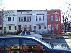
In the meanwhile, here’s a picture of the corner of 3rd and P. Compare with old picture of 3rd and P.