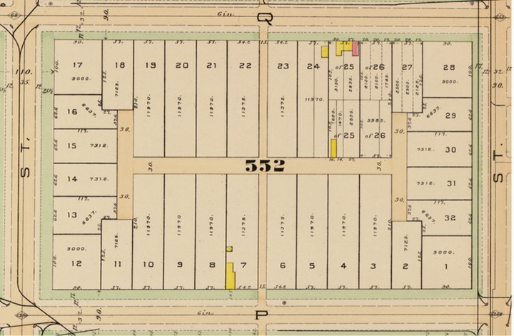
In the previous posts, I identified properties on Sq. 552 (bounded by 1st, P, 3rd and Q Sts NW) owned by the Washington Sanitary Improvement Company (WSIC). This post looks at 1st Street.
This is real easy. There were none owned by WSIC.
The even side of the 1500 block of 1st St NW were lots 177-182 (1536-1526 1st St NW), 197-201 (1546-1538 1st St NW), and 163-175 (1524-1500 1st St NW). Looking at the 1933 General Assessment, these were owned by a variety of individuals, not the WSIC.
There is sort of a pattern for the 200 block of Q St NW. There are 3 bays (200 has 1st and 2nd floor bays) for 200-204 Q St NW. Then 2 bay-less properties. However there is a new style of a shared porch entrance for bay-less 206-208 Q St NW. The bays return for two properties, at 210-212 Q St NW. 214-216 Q St NW are bayless with the shared porch. 218-220 Q St NW have the 2nd floor bays and 222-224 are bayless with a shared porch. But then what looks like what would be a bayed pair in the pattern, has both 2nd floor bay windows and a shared porch at 226-228 Q St NW.
226-228 Q St NW
And 230 Q St NW bookends this row with a 2 story bay, just like 200 Q St NW.
230 Q St NW
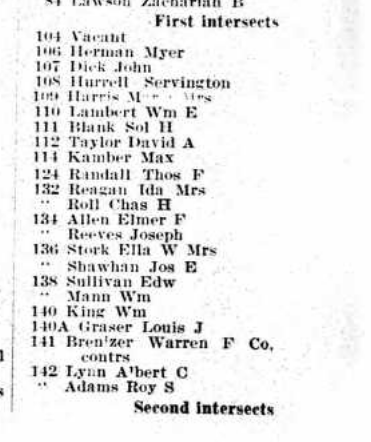
Since I did it for Part 1, below is from the 1917 DC City Directory showing two units per property. Keep in mind this is for the even side of Q St NW. 208 Q St NW, doesn’t appear to have an ‘A’ like the other houses from 200-230 Q St NW. But is does have two households.
We know that the Washington Sanitary Improvement Company (WSIC) did not own anything on Square 552 (Bounded by 3rd, P, 1st and Q St NW) in 1902. Sometime between 1903 and 1909 most of the block was purchased, developed, and Bates Street created. According to the 1933-1934 General Assessment WSIC owned lots 33-35, 49-94, 98-100, 104-150, 811, and 816-820.
Lots 33-35 would have been 137-141 Bates St NW; lots 49-94 were 1529-1551 3rd St NW, 138-230 Q St NW, 201-229 Bates St NW; lots 98-100 were 132-136 Q St NW; lots 104-150 were 131-135 Bates St NW, 207-231 P St NW, 1501-1523 3rd St NW, 200-230 Bates St NW, and 201-205 P St NW; lot 811 now lot 221 was 130 Q St NW; lots 816-818 being 119-123 Bates NW and lots 819-820 (originally part of lot 25) ?? Bates St NW.
Let’s start with 130-230 Q Street NW.
130 Q St NW
The above image is of 130 Q St NW and we see the 2nd floor bays that are similar to the bays of the unit block of Bates St NW. However, these are skinnier than the original style where WSIC started. Another difference, a single entrance for appears to be a two flat property. Whereas with the Bates St WSIC properties, there was a separate entrance.
As we start to go down the row it appears that the single bay properties are also single entrance but maybe single residence homes. However, 142 Q St NW seems to beg to differ.
A lot can happen in 100 years. Checking the census for 1910, there are two households for 132, 134, 136, and 138. Although I see two doors for 142 Q St NW, it had only one family in 1910.
Source: 1917 DC City Directory
Looking at the 1917 City Directory the houses from 132-142 have two households or two units.
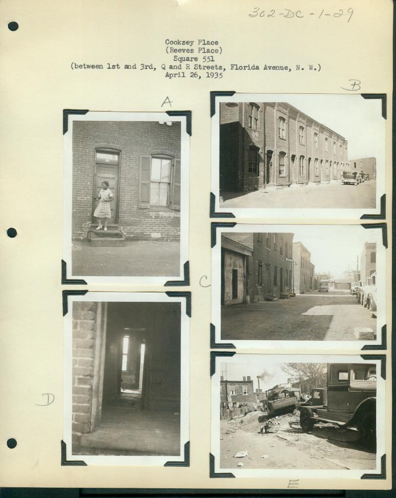
Somewhere, which is probably one of the parking lots of the Northwest Co-operative, was Cooksey Alley. It was on Sq. 551, which is bounded by 3rd St, Q St, 1st St, Florida Avenue and R St NW.
I was arranging my computer files and came across this:
I have probably posted this before. There were several other alley photos for other parts of the city and I’ll post those too.
Anyway, the Alley Dwelling Authority succeeded in their goal to get rid of alley’s like Cooksey Alley/Reeve’s Place, because it no longer exists.
Feeling a bit under the weather so the posts are going to slow down a bit.
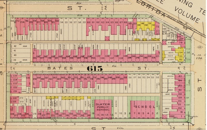
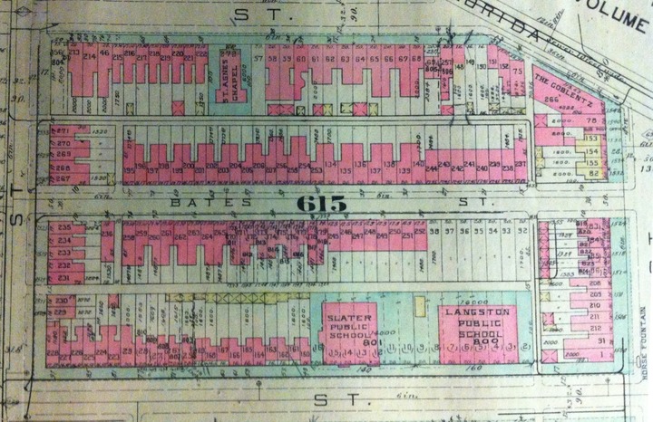
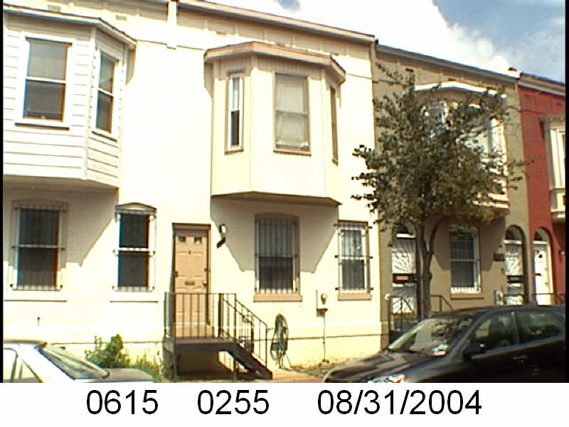
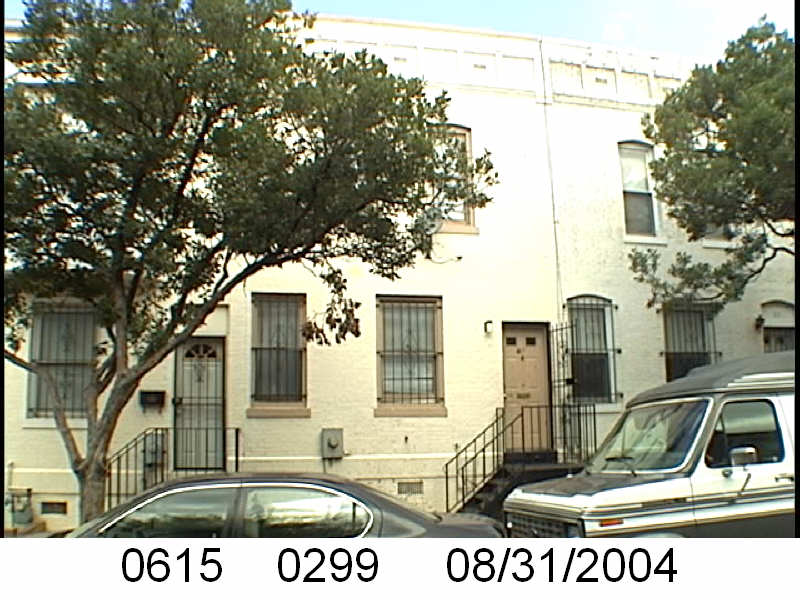
In an earlier post, WSIC- 1930s Ownership of Sq. 615, I wrote: “… the Washington Sanitary Improvement Company owned the following lots on Sq. 615 (bounded by North Cap, Q St, 1st St and P St NW): 65-66, 134-140, 170-179, 195-207, and 236-265.”
In a previous post I specifically looked at 31 and 33 Bates Street, part of 31- 43 Bates St NW, lots 134-140, now lots 285-291.
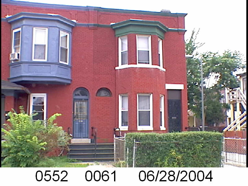
The Washington Sanitary Improvement Company owned the whole of the odd side of Bates Street, NW. And visually, for a bit, they had the 2nd story bay window, then no bay, then bay pattern, starting at 15 Bates to 37 Bates St NW. But 37 and neighboring 35 Bates St. NW are bay-less.
It begins to look like the bay-no-bay pattern will restart with 39-45 Bates St, but then there are a row of the distinctive Truxton Circle 2nd floor bay windows.
From 55-65 Bates St NW, it goes back to the bay, no bay, bay pattern. Addresses 65-67 Bates NW are bayless together, and then the pattern restarts.
The even side of the unit block of Bates is just as inconsistent. Just a little less so. It starts off with bay, no bay, then bay and keeps it up until 52-54 Bates Street with neighboring bay-less windows.
54-58 Bates St NW form a no bay, bay, no bay sandwich before it is nothing but bay windows till 1st St NW.
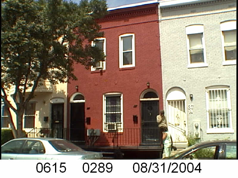
In a previous post, WSIC- 1930s Ownership of Sq. 615, I wrote: “… the Washington Sanitary Improvement Company owned the following lots on Sq. 615 (bounded by North Cap, Q St, 1st St and P St NW): 65-66, 134-140, 170-179, 195-207, and 236-265.”
I’m going to skip Square 615’s lots 65-66. which are 22 and 24 Q St NW. They do not look different from the other adjoining town homes.
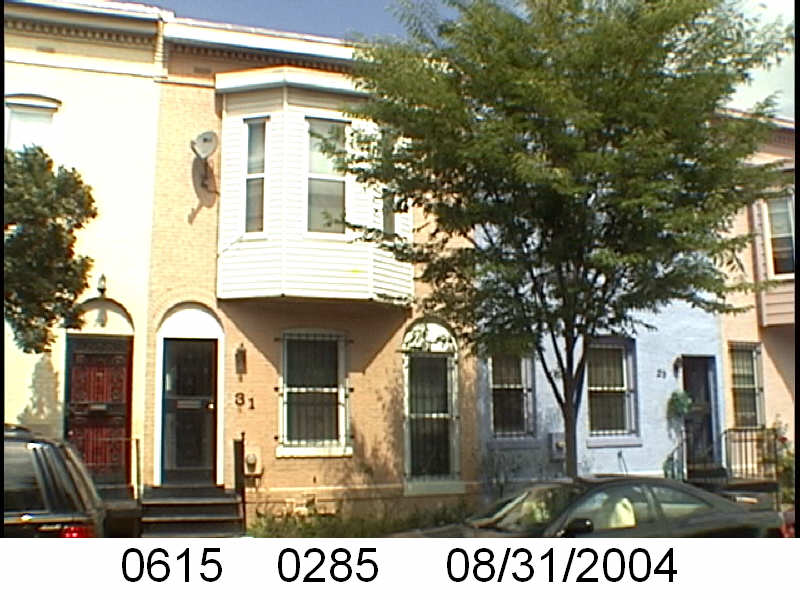
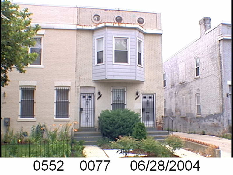
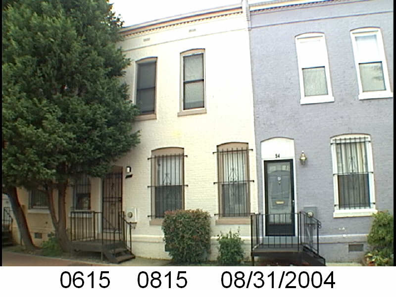
So let’s first look at lots 134-140. And here is where we find our first problem. The lot numbers changed. Lot 140 would be 31 Bates Street NW. That address is now lot 285. I find a lot number changes. Sometimes the property undergoes some sort of conversion or there is another reason for the lot number change. It doesn’t happen too often but it does happen.
31 Bates Street NW, 2004
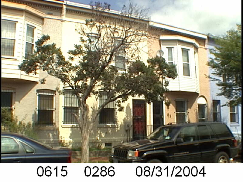
Next is lot 139, which like 140, no longer exists in the tax rolls. It was 33 Bates Street NW, which is now lot 286.
33 Bates St NW, 2004
So what are we seeing here in these two images of Bates Street NW houses. The image for 31 Bates St NW shows the distinctive 2nd floor centered bay and the two entrances, reflecting the Washington Sanitary Improvement Company’s (WSIC) idea of having a two flat unit. The second door, is a window in the image for lot 285.
The pattern for the row is bay, no bay, bay, no bay.
In my last post about the Washington Sanitary Improvement Company (WSIC) and Square 617 (bounded by 1st, N, North Cap, and O Streets NW) I said the architecture looked annoying. Take a look at the entryway below.
Note the stairs in the photo (0617 0225). The original iron stairs were replaced by brick and there doesn’t seem to be a clear line in the brick.
This works when the owner owns both buildings. This can cause all sorts of headaches when there are two different owners, with different attitudes about maintenance and repairs.
Please forgive me, I am not an architect and have very little interest in focusing on the architecture of Truxton Circle, because that just leads to the Great Satan that is historic districting. But WSIC buildings in the TC have distinctive bays. In the case of the O Street buildings, I think what I am seeing is a bay with adjacent entryways.
For 14 O St NW, this is fine.
It doesn’t have an entryway close to another unit’s entry. In the photo above, taken in 2004, it appears 14 O St NW was two units. Even the second unit is not too close to the neighboring house’s entry.
In the last Washington Sanitary Improvement Company (WSIC) post I searched the DC Recorder of Deeds for any other properties in Truxton Circle they may have owned besides the ones on Squares 552 and 615. I discovered Sq. 617.
On Square 617, they owned lots 169 to 183.
So that would be 14-42 O St NW.
This is 14 O St NW. Note the difference in lot number. It was lot 183 100 years ago.
This is 42 O St NW.
I’m noticing a particular building style here, but it looks irritating.
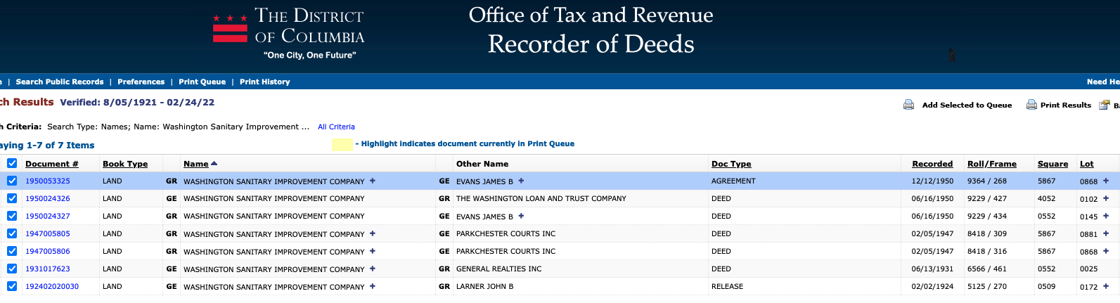
Just to cover my bases I’m going to check the Recorder of Deeds and see what else the Washington Sanitary Improvement Company (WSIC) owned around here.
Screen Shot from DC Recorder of Deeds
This image is deceptive.
There were more than 7 properties.
Let’s look at the earliest document, document #192402020030 a release, which means a debt was paid. It is dated February 2, 1924 and John B. Larner, surviving trustee, is the grantor, the one who held the debt. WSIC, along with the Washington Loan and Trust Company, George H. Harris, George M. Kober and George M. Sternberg, were the grantees, the ones who paid the debt. The document were for a whole list of properties on Square 509, which is juuuuust outside of Truxton Circle. They were for lots 170-181.
The next document was #1931017623 a 1931 deed. It is for one property, Square 552 lot 25 in Truxton Circle. Today it would be several properties with some facing the 100 blocks of Q and Bates Streets NW. But Sq. 552 has been covered and will get covered going forward, so I’ll move on.
Next are two 1947 deeds, document #1947005806 for Sq. 5867 and lots 3 and 868, and doc #1947005805 for about 37 lots on that same square. No clue where that is, besides east of the river in Southeast. Poking around it appears that square no longer exists.
In 1950 it appears WSIC sold properties in documents 1950024326 and 1950024327. These were lots on Squares 245, 4048, 4052, 509, E0546, 552, 615, 617, 651, 654, and 674. There were three TC squares in there and they were 552, 615, and 617.
Okay next time, we will look at Square 617 in addition to 552 and 615.
In 1903 parties (George Sternberg and George Kober) involved with the Washington Sanitary Improvement Company owned the following lots on Sq. 615 (bounded by North Cap, Q St, 1st St and P St NW): 65-66, 134-140, 170-179, 195-207, and 236-265.
Sq. 615 circa 1924
Fast forward to the 1933-1934 General Assessment, and it looks like the Washington Loan and Trust Company was holding or acting as a trustee for the WSIC.
There was a document that the WSIC owned the following lots in 1950. Lots 0134, 0135, 0136, 0137, 0138, 0139, 0140, 0170, 0171, 0172, 0173, 0174, 0175, 0176, 0177, 0178, 0179, 0195, 0196, 0197, 0198, 0199, 0200, 0201, 0202, 0203, 0204, 0205, 0206, 0207, 0236, 0237, 0238, 0239, 0240, 0241, 0242, 0243, 0244, 0245, 0246, 0247, 0248, 0249, 0250, 0251, 0252, 0253, 0254, 0255, and 0256. So basically the same lots, minus lots 65-66.
Next, I need to do a wide search to see if WSIC owned anything else in Truxton Circle, besides Squares 552 and 615. I don’t think so, but I need to check.

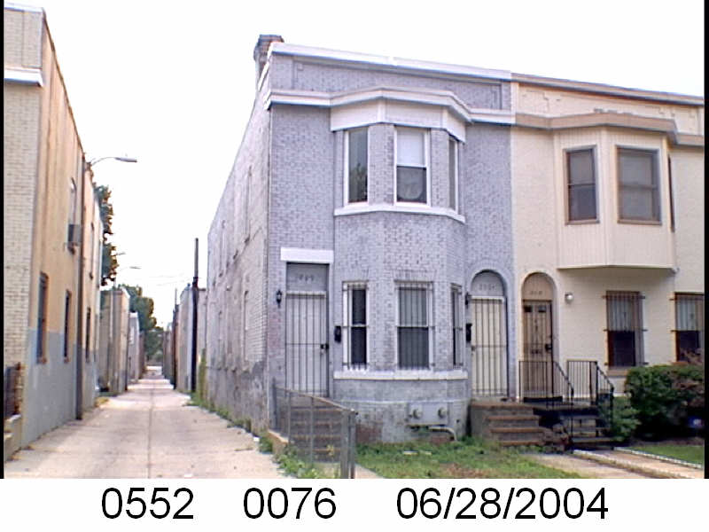
 So let’s first look at lots 134-140. And here is where we find our first problem. The lot numbers changed. Lot 140 would be 31 Bates Street NW. That address is now lot 285. I find a lot number changes. Sometimes the property undergoes some sort of conversion or there is another reason for the lot number change. It doesn’t happen too often but it does happen.