1957 Church Survey- Mt. Olivet Lutheran Church

This is part of a series where I look at churches that were surveyed in the 1957 Northwest Urban Renewal Area Church Survey. No other survey has been done since.

Mount Olivet Lutheran Church
Credit: Josh – https://www.flickr.com/photos/ncindc/


Mt. Olivet Lutheran Church sat at 1308 Vermont Ave NW in Logan Circle. In 1957 it was one of the two predominately African American Lutheran churches in the city. It’s current address is 1306 Vermont Ave NW.

So what was Mt. Olivet like in 1957? It had about 700 members who were mostly white collar workers. A small percentage of members lived in the Northwest Urban Renewal Area (see map above).  In the document below, it shows that 85% lived in the rest Continue reading 1957 Church Survey- Mt. Olivet Lutheran Church

Black Home Owners of Truxton Circle: Jessie and Edith Forrest

This time around I decided to have both spouses on the bill. Mainly because when I look at the few land records for 117 O St NW,  the wife’s name is right up there with her husband. But I may revert to just one owner, it’s simpler that way.

Like Christina Mack‘s property, this too goes with the old lot number and not a more precise lot number that would differentiate one part of lot 4, in this case, from another house on old lot four.

Portion of Sq. 553

There are just two land records, a release and a deed. Like Mrs. Mack and Mrs. Schools, the property was sold to the District of Columbia. It looks like I’ve stumbled upon the city buying up the properties to create Armstrong. In this case the city got the property in 1922.

The land records do not tell me how much the city paid for the property. If some one could point me to a source, I’d love to see it. I don’t know if the Forrests got a decent price. I suspect not. I located a 60 year old Jesse (no ‘i’) Forrest living at 116 Q St NW on a World War II draft card. He was not the owner of 116 Q St.

Edith, was Edith Green. Her mother, Roberta Green was living with the family in 1920. In 1900, little 8 year old Edith lived with her mother and father, George Green, as renters at 1520 3rd St NW. They were tenants of Richard Thornton, whose property ownership has already been reviewed.

I did a name search in the land records. After the property was transferred to the city, Mrs. Forrest bought a bunch of expensive furniture from the Julius Lansburgh Furniture Company, totaling $300 in October 1922. The furniture was to go to 117 O St NW. Was the city allowing them to stay in the property until they were ready to raze it for the school?

Black Home Owners of Truxton Circle- Willie T. Schools

Portion of Sq. 553

The next owner in this series was just a few doors down from our last subject Mrs. Christina Mack at 113 O St NW.

The land records tell a very short story. The story was Sq. 553 old lot 3 (it looks like lot 802 on the image above), was sold or transferred in 1923 to the District of Columbia by Mrs. Willie T. Schools, a Black dressmaker. There are two documents, the one I mentioned and a release. The release doesn’t say how much she borrowed and she didn’t borrow from an institution.

Nor do the land records give the name of her late husband. She is called a widow in the release and an unmarried woman on the deed.

She was a home owner for a few years. Prior to O Street she was at 1332 2nd Street NW from at least 1899 to 1910. In the 1915 city directory they had her at 123 O St NW. The 1924 city directory had her at 113 O St NW.  I’m not going to guess what was going on there. I’ll assume the directory was wrong because 123 O St NW was old lot 4, not 3. And the land records actually had 113 O Street NW.

She disappears from the record after 1924.

Mrs. Schools had a son named William Schools, who listed her as his next of kin when he was a private in the Summer of 1918 and in 1919. He listed his mother’s address as 123 O St NW.

Once again, by looking at the son, I find an interesting history of the mother. William R. Schools has a family tree on Ancestry and that lead to a 1910 census  which has his mom Willie as Lillie. It also says that her maiden name was Willie T. Byrd. Unfortunately, there was another Willie Schools (what are the odds) in DC living at 444 Q St NW, the widow of Macon Schools, and some of her data gets mixed in with the O St Willie Schools. And that’s where I’m going to end it.

Black Home Owners of Truxton Circle: Christina A. Mack

Okay let’s get back to the blog’s usual material, church surveys and a quick look at African American home owners.

There are only a few records for 107 O St NW where Christina A. Mack lived. She was listed as a home owner in the 1920 census. The problem with the address is that it is one of those places in the TC that no longer exists and has been absorbed into another property. It is now part of Armstrong’s campus.

Portion of Sq. 553

So there are three records for 107 O St NW or Sq.553 lot 129. The first is a release, not a deed, from 1924 and it seems to transfer the property from Christina and Thomas W. Mack to Albert F. Fox a trustee. The other two documents were deeds, one for 1930 and the other for 1931 which transferred the property to the District of Columbia.


In the 1920 census Mr. Thomas Mack, her husband is missing. She is listed as married and the head of household. The only other Thomas W. Mack is her 12 year old son. But with the land record we know he exists.

Mrs. Mack seems to only appear in the 1920 census. I could not locate her in the 1930 census nor the 1910 census. There is a reason why I couldn’t find her in the 1930 census, she died June 1925. After going another route, I found her and her son and daughter, living with her brother Eli Brooks and his wife in 1910.

I was able to find out what happened to Christina by looking for her son Thomas W. Mack (Jr?). His World War II draft card showed him living at 801 N St NW with his sister Eunice Viola Rabb. I also noticed on his draft card the words “Deceased” written at the top.

1969 Proposal to make the Co-op, FL Ave Park- Square 551 as we know it

From the history pile. I don’t know if I had posted this particular document, but I think I posted something about the change that happened with Sq. 551, but Can’t find it.

For those of you who don’t know, Sq. 551 is the large block bounded by 3rd St, R St, Florida Ave, 1st St, and Q St NW. Prior to urban renewal and the change it was a collection of alley dwellings, townhomes, commercial buildings and warehouses. Now it is the Northwest Co-operative, the Florida Avenue Park and the Mt. Sinai Baptist Church property. There are no private homes on that block.

The document below, dated October 27, 1969 proposes getting rid Continue reading 1969 Proposal to make the Co-op, FL Ave Park- Square 551 as we know it

Rando Bloomingdale History- List of properties owned by George N. Beale

I don’t feel like writing a big intro. I had this piece of paper in my pile. It isn’t Shaw history. It isn’t Truxton Circle history. It’s a letter and a table list from January 1920 from the estate of George N. Beale.

DcHistory Bloomingdale Prop… by Mm Inshaw

Crank File- Rita Raymond of 1514 5th St NW

I’ve been holding on to this file out of respect for the ‘crank’ in the file. The crank was Rita Raymond, also known as Carolyn Phillips, aka Mary Dorn, aka Carolyn Mullen. I’m going to guess she’s dead by now. In 1948 she was arrested and released to the custody of her father. The next year, 1949 she was charged with petit larceny, so I’ll assume she was an adult. It’s 2021, she should be dead by now.

Rita Raymond’s Rap Sheet

At one point in time Rita lived at 1514 5th St NW and going by the name Mrs. Carolyn Phillips. She wrote a letter in 1963 from this address complaining about other people, including a woman who lived in her building. It seems that in 1963, this house (now worth over a million) was a rooming house.

When I first read this I thought she was a busybody neighbor. But as I read her file and saw her rap sheet (above), I realized she was suffering from mental illness. Continue reading Crank File- Rita Raymond of 1514 5th St NW

The Uniqueness of the 1957 Church Survey

Over the past few years I have been publishing bits and pieces of the 1957 Church Survey [of the] Northwest Urban Renewal Area on this site. This was a very unique survey and it was not repeated again.

The 1957 survey was a look at churches in what was the Northwest Urban Renewal area. This area’s boundaries were roughly, starting at the southern border I and 15th Street to NY Ave to Mt. Vernon Square, to Massachusetts Ave,  2nd St NE, Florida Ave, then 15th St NW to the west.

The quality of the individual church surveys have varied. New Hope Baptist had nothing worth writing home about and churches like Mt. Sinai and First Rising Mount Zion have more information.

There was another survey in 1970. It wasn’t as rich as the 1957 survey. Churches in Shaw: A Report of the Survey of Churches in the Shaw Urban Renewal Area of Washington, D.C., 1970 , seen below, does not look at each and every individual church. The churches are all lopped together in one report.

The 1970 report does have a useful appendix of the churches that still exist as of Continue reading The Uniqueness of the 1957 Church Survey

54 Hanover Street NW- 1923

The address is actually 54-64 Hanover Street NW, which is a warehouse. And I will say was a warehouse in 1923 when the below correspondence was written.

DC History HanoverBus Corr1923 by Mm Inshaw

Not sure what the deal was as I only have the two letters. Both letters are from H. Jeffrey. It looks like he changed his business name, or at least used different letterhead in February and May of 1923 when writing to the Rent Commission of the District of Columbia. In February it was H. Jeffrey And Company, an import, government surplus, chemical, drugs and oils business. In May he was apparently running a paper box company with the Columbia Specialty Paper Box Company.

55 P St NW- bad rental in 1923

photo of property

I’ve been reaching into the pile and today I have a letter from 1923 regarding poor living conditions at 55 P St NW in the TC. The initial letter was from Walter W. Brown who wrote to the Rent Commission. The Rent Commission responded to him about paying rent but did not address the living conditions.

Feb 19 1923 Letter RE 55 P St NW by Mm Inshaw on Scribd

The Brown family appears in the 1920 census. We find Mr. Walter W. Brown, a 49 year old African American driver, living with his wife Lizzie, and their minor sons and daughter, adult daughters and one son-in-law. They are renters.

In the letter Brown writes that he lives a 55 Pea St NW. People did cute things like that, calling Q St, Que St, I St, Eye St, and the like. I hadn’t seen anyone call P St Pea St before. Anyway, at 55 P St, the plaster was falling down in various parts of the house, there was no septic and the stove was broken.

Mr. Brown mentions a Mr. Schwartz at 724 15th St NW. I checked the 1923 city directory and the inhabitants of that address was Schwartzell Rheem & Hensey Co. a real estate company. Were the realtors or property managers letting the house go to pot so they could get rid of the renters, rehab it and rent it at a higher price? I don’t know.

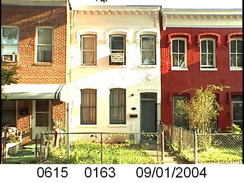
According to the Tax Assessment office, what is currently at 55 P St NW, was built in 1924. I could only find one permit for that lot pre- 1958. The earliest record I can find for Sq 615 lot 163 is from 1944. That was when Fred D. Geisler purchased the property. So it could be a completely different house.

I checked the Library of Congress to see if the lot number changed. The 1919 map shows lot 163. where lot 163 should be, with a brick house on it.

So that’s that.